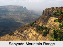
 The Sahyadri range is the physical backbone of the state since its average height is around 1000m and its average elevation is around 900 meters. It is parallel to the western coast of the Indian peninsula. The Western Ghats traverse the states of Kerala, Tamil Nadu, Karnataka, Goa, Maharashtra and Gujarat. The range starts near the Songadh town of Gujarat, south of the Tapti river and ends at Marunthuvazh Malai, at Swamithope, near Cape Comorin or Kanyakumari, the southern tip of the Indian peninsula. The range falls to a steep cliff, on the west, near the Konkan. The Konkan area exists between the Sahyadri range and the Arabian Sea.
The Sahyadri range is a UNESCO World Heritage Site. It is one of the eight "hottest hot-spots" of biodiversity in the world. The Western Ghats are older than the Himalayas. Thirty-nine areas in the Western Ghats have been given the designation of world heritage sites in 2012 – twenty in Kerala, ten in Karnataka, five in Tamil Nadu and four in Maharashtra. These areas include wildlife sanctuaries, national parks and reserve forests. The Sahyadris provide a wide choice of adventure to all nature lovers like the trekkers and climbers. This range is known as the Sahyadri mountains in Maharashtra and Karnataka, Nilagiri malai in Tamil Nadu, and Sahya Parvatam in Kerala.
Geography of the Sahyadris Mountain Range
The Western Ghats are the faulted and eroded edge of the Deccan Plateau. According to geological evidences, the breaking-up of the supercontinent Gondwana about 150 million years ago, formed the Western Ghats. The Sahyadris influence Indian monsoon weather patterns. The range intercepts the rain-laden monsoon winds that sweep in from the south-west during late summer.
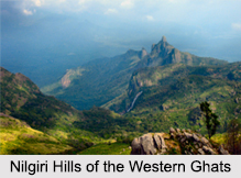
The central portion of the coastal plain is called Kanara and the southern portion is called Malabar region. In the eastern side of the Ghats, there"s the foothill region which falls in Maharashtra. It is known as Desh. The eastern foothills of the central Karnataka state is known as Malenadu. The Western Ghats are connected with the Eastern Ghats at the Nilgiri mountains in Tamil Nadu. The Nilgiris connect the Biligiriranga Hills with the Shevaroys and Tirumala hills. There are the Anamala Hills, located in western Tamil Nadu and Kerala. The Cardamom Hills is also another range. There are the Aryankavu pass and Aralvaimozhi pass near Kanyakumari. In the southern part of the range lies the Anamudi (2,695 metres (8,842 ft)), the highest peak in the Western Ghats.
 The major river systems originating in the Western Ghats are the Godavari, Kaveri, Krishna, Thamiraparani and Tungabhadra. Primary tributaries include the Kali, Bhadra, Bhavani, Bhima, Malaprabha, Ghataprabha, Hemavathi and Kabini. The Periyar, Pamba, Netravati, Sharavathi, Mandovi and Zuari rivers flow towards the Western Ghats and finally into the Arabian Sea. Dams have been constructed across the rivers for hydro-electric and irrigation projects. Major projects in this region are Koyna in Maharashtra, Linganmakki and Shivanasamudra in Karnataka, Mettur and Pykara in Tamil Nadu, Parambikulam, Malampuzha and Idukki in Kerala. There are famous waterfalls in this region also like Dudhsagar waterfall. It is a four-tiered waterfall on Mandovi river, in Goa.
Climate of the Sahyadris Mountain Range
Heavy rainfall occurs in the surrounding regions mainly because there are no passes and gaps between the mountains. Maharashtra and the northern Western Ghats in Karnataka receive heavier rainfall than Kerala and the southern part of Western Ghats in Karnataka. Agumbe, Hulikal and Amagaon in Karnataka, Mahabaleshwar and Tamhini in Maharashtra are also known as the "Cherrapunji of southwest India" or the "rain capital of southwest India". The climate is humid in the lower altitude regions because of proximity to the sea. The climate becomes temperate with gradual elevation. The average annual temperature in the region is around 15 degree C. During monsoon, the eastward-moving rain-bearing clouds rise, and thus heavy rainfall occurs on windward side. The eastern part of Western Ghats lie in the rain-shadow region and thus it receives less rainfall.
Ecology of the Sahyadris Mountain Range
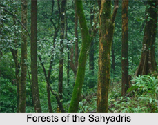
Western Ghats comprise of four tropical and subtropical broadleaf forest eco-regions: the North Western Ghats moist deciduous forests, North Western Ghats montane rain forests, South Western Ghats moist deciduous forests and South Western Ghats montane rain forests. These forests are the most species-rich region in peninsular India. Earlier, the Western Ghats were covered in dense forests that became the natural habitats for the tribal people. The forest has now been broken up and scattered due to human activities, especially for tea, coffee and teak plantations.
 Flora and Fauna in the Sahyadris Mountain Range
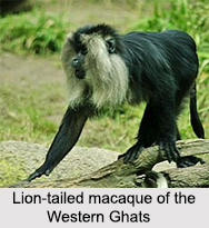
The Western Ghats are home to 7,402 species of flowering plants. The Ghats are home to 325 globally threatened animal species. The fauna of western ghats includes 139 mammal species, reptiles, the amphibians- endangered purple frog, 102 species of fish, molluscs, annelids, 508 bird species and around 6,000 species of insects. The Sahyadris are home to thousands of rare mammals including the black panther, Leopard and the royal Bengal tiger. The lion-tailed macaque and malabar large-spotted civet are the endangered mammals of the Western ghats. The famous Nilgiri bio-sphere is home to the largest population of Asian elephants. It is an important project for elephants and a project tiger reserve as well. The Nilgiri Marten and Nilgiri Tahr are two of the rarest animals in the region.
There are 508 species of bird in the Sahyadris. The Malabar parakeet, nilgiri wood-pigeon, malabar grey horn bill, grey-headed bulbul, nilgiri flycatcher and other giant flying predators are the endemic birds of the Western Ghats.
There is a huge diversity of reptiles in the Western Ghats, including one of the most dangerous snakes- a Viper. There are 13 species of lizards. The monitor lizard, dwarf gecko and the malabar flying lizard are some of them. The Sahyadri is also home to the largest venomous snake of world, king cobra. There are crocodiles and other venomous exotic reptiles in the region. More than 80% of the 179 amphibian species are endemic to the region. This includes endangered purple frog and Malabar flying frog. Four new species of anurans have also been discovered recently from here. Around 218 primary and secondary freshwater fish species inhabit the rivers and streams of Western Ghats. There are ornamental fish species, like barb and catfish. The Godavari, Krishna and Kaveri have numerous waterfalls and lakes. These are home to many species of fishes.
 Biodiversity protection projects of the Sahyadris Mountain Range
In 2006, India applied to the UNESCO Man and Biosphere Programme (MAB) for enlisting the Sahyadris Mountain Range as a protected World Heritage Site. Some of these places are as follows:
•Kali Tiger Reserve
•Indira Gandhi Wildlife Sanctuary and National Park
•Mundigekere Bird Sanctuary
•Kalakkad Mundanthurai Tiger Reserve
•Thattekad Bird Sanctuary
•Shendurney Wildlife Sanctuary
•Neyyar Wildlife Sanctuary
•Peppara Wildlife Sanctuary
•Periyar Tiger Reserve
•Silent Valley National Park
•Mukurthi National Park
•Pushpagiri Wildlife Sanctuary
•Brahmagiri Wildlife Sanctuary
•Mookambika Wildlife Sanctuary
•Megamalai Wildlife Sanctuary
•Palani Hills Wildlife Sanctuary and National Park
•Kanyakumari Wildlife Sanctuary
•Bandipur National Park
•Nagarhole National Park
•Nilgiri Biosphere Reserve
Sahyadris Mountain Range
The Sahyadris is a range of mountains in southwestern India, also known as the "Western Ghats". It has very rough topographical features that include rocky mountains, pinnacles and extensive forest region. It is also known as the Great Escarpment of India.


