
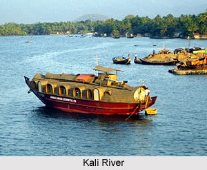
 Kali River, also known as the Sharda River and Mahakali River, originates from the Greater Himalayas at Kalapaani in the Pithoragarh district of Uttarakhand at an altitude of 3600 metres. The river is named after Goddess Kali, and her temple is located at Kalapaani near the Lipu Lekh pass, which is situated at the boundary of India and Tibet.
Origin and Course of Kali River
On its upper course from Kalapani to Tanakpur, the Kali River forms a continuous eastern boundary with Nepal. Having its origin in the trans-Himalayan zone, the river is called Sharda in the plains. The river is about 400 km long and has a basin area of 14,871 km. sq. It flows along Nepal`s western border with India and joins the Ghaghra River, a tributary of the Ganges.
The River enters the Terai plains after Brahmadev Mandi near Tanakpur, where it is called Sharda River. The river offers immense potential for irrigation and generation of hydroelectricity. It serves as the boundary between Uttarakhand`s Kumaon Division and Nepal from a little below the Kalapani encamping ground. The Lipulekh pass as well as the Limpayadhura pass or Limpiya pass are on Uttarakhand`s border with Tibet.
The Kali River finally merges with the Gori Ganga at Jauljibi where a fair is held every year. The River then joins the Saryu River at Pancheshwar and therefore the area around Pancheshwar is called `Kali Kumaon. Belonging to the Ganges river system, the Kali River finally merges with the Ganga.
Potential and Challenges of Kali River
The Kali River offers potential for hydroelectric power generation, and the river is proposed as a source for one of the many projects in the Himalayan component of the Indian Rivers Inter-link project. The Pancheshwar Dam, a joint venture of India and Nepal for irrigation and hydro-electric power generation, was proposed on this river in 1995. However, Nepal and India have been unable to reach a decision on the 5,600-MW Pancheshwar multipurpose dam project because of political changes in two countries.









