
The Wakal River flows through the Indian states of Rajasthan and Gujarat. It is a
tributary of the Sabarmati
River, one of India’s major west-flowing rivers, which originates in
the Aravalli
Range.
Wakal River
The Wakal River is an important tributary of the Sabarmati River, originating in Rajasthan’s Aravalli Range and flowing through Rajasthan and Gujarat. Its basin supports agriculture, drinking-water supply, and irrigation.
Introduction
Course of the Wakal River
The Wakal River originates in the Aravalli Range of
Rajasthan’s Udaipur
district and flows for approximately 158 kilometres before merging with
the Sabarmati River in Gujarat’s Sabarkantha district.
Its two principal tributaries are the Mansi and Parvi rivers. The Mansi River
is particularly known for the Mansi Wakal Dam, which has been constructed
across it in Udaipur district.
Watershed in Wakal River
The Wakal River watershed covers an area of approximately
1,851 square kilometres, extending across Udaipur district in Rajasthan and
Sabarkantha district in Gujarat. About 98% of the basin area lies within
Rajasthan, while the remaining 2% is situated in Gujarat. The basin has a mean
annual surface water yield of approximately 319.4 million cubic metres.
Irrigation Projects on Wakal River
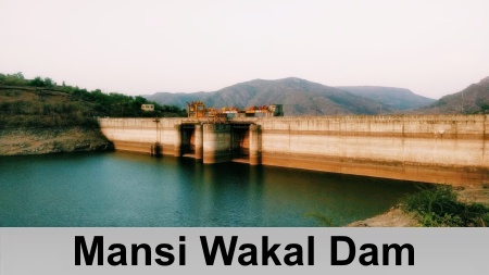 The Wakal River watershed has 24 minor irrigation
projects with a combined live storage capacity of approximately 65.98 million
cubic metres. Among the various water infrastructure projects in the basin, the
Mansi Wakal Dam is the largest dam and plays an important role in the region’s
water management and irrigation system.
The Wakal River watershed has 24 minor irrigation
projects with a combined live storage capacity of approximately 65.98 million
cubic metres. Among the various water infrastructure projects in the basin, the
Mansi Wakal Dam is the largest dam and plays an important role in the region’s
water management and irrigation system.
Located approximately 7 kilometres north of Jhadol village, the Mansi Wakal Dam forms a reservoir with a storage capacity of about 24.4 million cubic metres. The reservoir primarily supplies drinking water to Udaipur city, contributing around 23% of its drinking water requirement. It also provides drinking water to rural areas of Udaipur district and supports industrial water needs.
Challenges Faced by Wakal River Basin
Rajasthan, located in north-western India, is one of the country’s driest and most economically disadvantaged regions. Wakal River Basin is located in the southern part of Rajasthan where Thar Desert covers much of the area. This region experiences extreme temperatures and receives very little annual rainfall. Surface water resources are limited because rainfall rapidly infiltrates the ground, while high evaporation rates further reduce water availability.
The Wakal River region also faces significant water-supply
challenges due to historical mismanagement of water resources.
Excessive irrigation has contributed to waterlogging and soil salinisation,
while the unregulated extraction of groundwater through pumps has depleted
aquifers, lowered water tables, and caused wells to dry up. Limited
coordination in water management has also compounded the problem, as access to
wells is often controlled by individual households and villages. Unregulated
water use has reduced the natural recharge of groundwater sources, making water
scarcity an increasingly serious concern in the region.
Wakal River Basin Project
The Wakal River Basin Project, located in southern Rajasthan, was supported by funding from the United States Agency for International Development (USAID) under the Global Water for Sustainability Program between 2004 and 2014. The initiative focused on improving water security by involving local communities in water-resource management.
The project aimed to increase water availability and storage through locally adapted solutions while raising community awareness about sustainable water management practices. Local communities played an active role throughout the initiative and were responsible for establishing and maintaining the water-management schemes.
The Wakal River Basin Project has promoted rainwater harvesting as a means of increasing water availability in local villages. One of the key measures involves the construction of taankas, or underground storage tanks, which collect and store rainwater harvested from rooftops. The project has also supported the development of joheds, small earthen dams that capture rainwater and have helped raise the groundwater table by up to 6 metres.
In addition, pats, or irrigation canals, have been developed to channel water stored by joheds to agricultural fields for crop irrigation. Education and community awareness form an important part of the project, with local communities being encouraged to understand and practice water conservation. This collective participation helps strengthen long-term water security in the region.
Recently updated articles in Geography of India

Krishnaveni River
The Krishnaveni River, presently known as the Krishna River, is one of India’s major rivers. Originating in the Western Ghats of Maharashtra, it flows...

Wakal River
The Wakal River is an important tributary of the Sabarmati River, originating in Rajasthan’s Aravalli Range and flowing through Rajasthan and Gujarat....

Pahuj River
Pahuj River is an important tributary of the Sindh River that flows through the Indian states of Madhya Pradesh and Uttar Pradesh. Originating in the...

Arunavati River
Arunavati River is a seasonal right-bank tributary of the Tapi River, flowing through parts of Madhya Pradesh and Maharashtra. Originating in the Satp...

Nira River
Nira River is an important tributary of the Bhima River flowing through Maharashtra. Originating in the Western Ghats, it traverses Pune, Satara, and...
Related articles in Geography of India

Geography of Sikkim
Geography of Sikkim is characterised by a vast array of magnificent hillock that extends from one corner of the state to the other.

Geography of Meghalaya
The suitable climate, highland plateaus, rivers and the flora and fauna together forms the geography of Meghalaya.

Geography of Jammu & Kashmir
Jammu and Kashmir is encompassed by valleys. Some of the dominant valleys of the state are Kashmir Valley, Tawi Valley, Chenab Valley, Poonch Valley,...

Narmada River
Narmada River is regarded as the 5th longest river of India and the life line of Madhya Pradesh. Narmada River basin spreads over an area of about 98,...

Bhima River
The Bhima River is the largest tributary of the Krishna River and is significant in the western and southern Indian states.