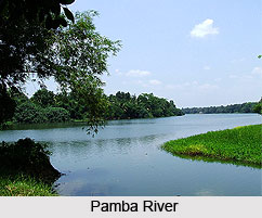
 Pamba River which is also known as Pampa river is the third longest river in the South Indian state of Kerala after Periyar River and Bharathappuzha River and the longest river in the erstwhile princely state of Travancore. It has a length of about 176 km and a catchment area of about 2235 sqkm. The Sabarimala temple dedicated to Lord Ayyappa is located on the banks of the River Pamba. A famous Anjana temple is also situated near this bank.
The Pamba is considered as the "Dakshina Ganga" due to its association with Kerala"s Largest Pilgrim Centre - Sabarimala Temple. The river is also known as "Dakshina Bhagirathi" and "River Baris". The River Pamba enriches the lands of Pathanamthitta District and the Kuttanad area of Alappuzha District. Kuttanad, an important rice cultivating area in Kerala gets the irrigation water from the Pamba River. The main tributaries of the river are Kakki Ar, Azhuta Ar, Kakkad Ar, Kallar, Manimala and Achenkovil.
Course of Pamba River
Pampa originates at Pulachimalai hill in the Peerumedu plateau in the Western Ghats at an altitude of 1650 metres and flows through Ranni, Kozhenchery, Tiruvalla, Chengannur, Kuttanad, Karthikapally, and Ambalappuzha Taluks and finally empties into the Vembanad Lake.After traversing a distance of 176 km, the river joins the Arabian Sea through a number of channels. The basin extends over an area of 2,235 sqkm with the entire catchment area within Kerala state. The Pamba basin is bounded on the east by the Western Ghats. The river shares its northern boundary with the Manimalla River basin, while it shares the southern boundary with the Achankovil River basin.
 Geography of Pamba River
Like all the river basins in Kerala, the Pamba basin also can be divided into three natural zones based on elevation, consisting of low land or sea-board, midland and high land. The coast for a short distance along the borders of lakes is flat, retreating from it the surface roughens up into slopes which gradually combine and swell into mountains on the east. The low land area along sea coast is generally swampy and liable to be flooded during monsoon inundation. The plains succeed low land in gentle ascents and valleys interspersed with isolated low hills. The high land on the eastern portion is broken by long spurs, dense forests, extensive ravines and tangled jungles.
Endangered State of Pamba River
Due to drought and lack of conservation and protection by the government, the Pampa River has shrunk to a stream and is totally dry in many places. Water for farming, such as paddy fields, is scarce. Experts are calling for a governmental awareness of the dire situation and the need to rein in development that is destroying the environmental before it is too late.
Significance in Hinduism of Pamba River
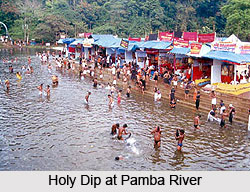
Lord Ayyappa appeared to the Pandalam Raja as a child on the banks of the Pamba River. The Pamba River has been venerated as southern Ganga, and devotees of Lord Ayyappa believe that immersing oneself in the Pamba is equivalent to bathing in the Holy Ganges River. Bathing in the river, believed to forgive one"s sins, is a requirement before commencing the trek through the forest to the Ayyappa Temple atop Sabarimala.
Snake Boat Race at Pamba River
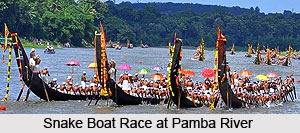
The Snake boats are one of the cultural gifts to the Keralites by the "River Pampa".
 The snake boat race is one of the important "Traditional Game" in Kerala. One of the most important snake boat races is being conducted at Aranmula in the River Pampa. Aranmula Boat festival is connected to the Annual Onam Festival of Kerala. About 35 Snake boats called "Palliyodams" participate in the Aranmula "Uthruttathy Jalolswom". The Aranmula Jalolswom is steadily and fast growing into a great international event in India. The Aranmula Boat race is the biggest domestic tourist event which attracts millions every year.


