 Indian Mountain Peaks are characterized by serrated ridges and scraggy crests. The lofty peaks with their beauty and grace have epitomized the magnificence of India since ages. Be it the snowcapped splendor of the Himalayan peaks or the lushness of the Western Ghat peaks, the very clasping Mountain Peaks of India delineate Indian geography to a great extent.
The Mountain Peaks of India like Abu Gamin, Agastya Malai, the Arwa Group, etc are given below.
Indian Mountain Peaks are characterized by serrated ridges and scraggy crests. The lofty peaks with their beauty and grace have epitomized the magnificence of India since ages. Be it the snowcapped splendor of the Himalayan peaks or the lushness of the Western Ghat peaks, the very clasping Mountain Peaks of India delineate Indian geography to a great extent.
The Mountain Peaks of India like Abu Gamin, Agastya Malai, the Arwa Group, etc are given below.
Abu Gamin
Abu Gamin is a Himalayan peak situated in the Chamoli district of Uttarakhand. It is located in the central Himalayas at the culminating point of the Zanskar Range.
Arwa Group
Arwa Group is located in the Chamoli district of Uttarakhand. More specifically, it is a group of three Himalayan peaks namely, Arwa Tower, Arwa Crest and Arwa Spire.
Avalanche Peaks
Avalanche Peaks are two mountain peaks located above the Arwa Valley in the northwest of Badrinath in Uttarakhand.
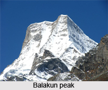
Balakun Peak
Balakun Peak is located in the Chamoli district of Uttarakhand, 16 km from Badrinath.
Bamba Dhura
 Bamba Dhura, a Himalayan peak is located in the Pithoragarh district of Uttarakhand, at a height of about 6,334 meters above mean sea level.
Changabang
Changabang is a steep and rocky peak located in the Garhwal Himalaya of Uttarakhand.
Chaudhara
Chaudhara Peak is situated in the Pithoragarh district of Uttarakhand at a height of about 6,510 meters. It is so named because it has four corners.
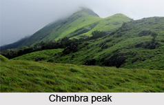
Chembra Peak
The highest peak in Wayanad in Western Ghats is Chembra Peak, which is located at a height of about 2100 meters above mean sea level.
Chiring We
Chiring We, situated in eastern Kumaun of the Pithoragarh district of Uttarakhand is the highest peak above the Kalabaland Glacier.
Dunagiri
Dunagiri, a peak in the Chamoli District Himalayas in Uttarakhand has a height of about 7,066 meters (23,182 feet) above mean sea level.
Guru Shikhar
Guru Shikhar peak in the Arbuda Mountains of Rajasthan is the highest point of the Aravalli Range. It has a height of about 1,722 m (5,650 ft) above mean sea level.
Hardeol
Hardeol is situated at the northern end of the Milam Valley in the Pithoragarh district of Uttarakhand. It is the highest peak on the northern side of the ring of peaks guarding the Nanda Devi Sanctuary.
Kangla Tarbo 1
Kangla Tarbo 1 is a mountain peak located in the Lahaul and Spiti district of Himachal Pradesh.
Kodachadri
Kodachadri, a natural heritage site and the 10th highest peak of Karnataka is a part of the Western Ghats. 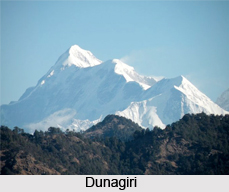
Mamostong Kangri
Mamostong Kangri is the highest peak in the remote Rimo Muztagh and is located about 30 kms east southeast of the snout of the Siachen Glacier.
Mullayanagiri
Located in the Chandra Dhrona Hill Ranges of the Western Ghats of Chikkamagaluru Taluk, Mullayanagiri is the highest peak in Karnataka.
Nanda Devi
Nanda Devi is the second highest mountain in India and the highest located entirely within the country. It is a part of the Garhwal Himalayas and is located in Uttarakhand.
Nanda Gond
Nanda Gond, a Himalayan mountain peak is located in the Milam Valley in the east of the Milam Glacier in the Pithoragarh district of Uttarakhand.
Nanda Kot
Nanda Kot, a Himalayan mountain peak is located in the Pithoragarh district of Uttarakhand.
Nilkantha
Nilkantha is a Himalayan peak in the Garhwal Division in the state of Uttarakhand.
Panchchuli
Panchchuli are a group of five snow-capped peaks in the Himalayas, at the end of the eastern Kumaon region near Munsiari in Pithoragarh district in Uttarakhand.
Pushpagiri
 Pushpagiri, located in the Somwarpet Taluk is the highest peak in Pushpagiri Wildlife Sanctuary in the Western Ghats of Karnataka.
Rajrambha
Rajrambha is a Himalayan peak situated in the Pithoragarh district of Uttarakhand, south of the Kalabaland Glacier in eastern Kumaun in the Ralam Valley.
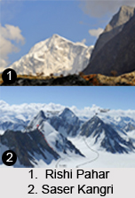
Rishi Pahar
Rishi Pahar is located in the Pithoragarh district of Uttarakhand, at the northeast corner of the ring of peaks surrounding the Nanda Devi Sanctuary and on the eastern rim of the Nanda Devi Biosphere Reserve, south of Trishuli and Hardeol.
Sandakfu
Sandakfu is the highest point of the Singalila Ridge in Darjeeling district on the West Bengal-Nepal border.
Sangthang
Sangthang is a Himalayan peak situated in the easternmost part of Kumaun at an altitude of about 6,480 meters above mean sea level.
Saser Kangri
Saser Kangri is situated within Jammu and Kashmir and is the highest peak of the Saser Muztagh, the easternmost sub-range of the Karakoram Range.
Sherpi Kangri
Sherpi Kangri is a mountain peak in the Karakoram Range, south of the Ghent Kangri. It has a height of about 7,380 m (24,210 ft).?
Siniolchu
With a height of about 6888 meters above mean sea level, Siniolchu is one of the highest peaks in Sikkim.
Sonsogor
Sonsogor is located in the taluka (county) of Sattari in Goa. It is the highest peak in the state with a height of about 1,166 meters above mean sea level.
Suj Tilla East
Suj Tilla East is a Himalayan peak located in the eastern part of Uttarakhand in the Pithoragarh district. It has a height of about 6,394 meters above mean sea level.
Suli Top
Suli Top is situated over the eastern flank of the Kalabaland Glacier, east of the Johar Valley.
Tadiandamol
Tadiandamol is the highest mountain peak in Kodagu district in Karnataka and is a part of the Western Ghats Range. With a height of about 1,748 meters above mean sea level, it is the fourth highest peak in Karnataka.
Trishul
Trishul is a group of three Himalayan mountain peaks in western Kumaun in Uttarakhand. Among the three, the highest peak is Trishul which has a height of about 7120m.
Uja Tirche
Uja Tirche is a peak located in Uttarakhand and is a part of the Nanda Devi group of the Kumaon or Garhwal Himalaya.


