
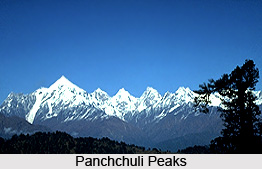
 Panchchuli is a group of five snow capped Himalayan peaks, which lies at the eastern Kumaon region. The peaks form the drainage divide between the Gori and the Darmaganga valleys. Every year, Panchchuli Peaks draw adventure enthusiasts, photographers, and explorers from various corners of the world.
Location of Panchchuli Peaks
The peaks are located in the Pithoragarh district of Uttarakhand state of India. They are situated on the Gori Ganga-Lassar Yankti divide. The peaks are situated at an average elevation of 6,334 meters (20,781 feet) to 6,904 meters (22,651 feet) above mean sea level. The group of mountain peaks lie one thirty-eight kilometres from Pithoragarh.
Etymology of Panchchuli Peaks
The word Panchchuli means `five stoves` and it is believed to be the place where the Pandavas cooked their last meal on the way to heaven. The five peaks of the Panchchuli massif are named from northwest to southeast.
Panchchuli I: The Panchchuli I is situated at a height of 6,355 meters above mean sea level and its coordinates are Latitude 30 degree 13`12" Longitude 80 degree 25`12". It was first scaled by Indo-Tibet Border Police team in the year 1972, via Uttari Balati glacier, led by Hukam Singh.
Panchchuli II: The Panchchuli II, which is the highest peak in the group, is situated at a height of 6,904 meters above mean sea level. The coordinates of the peak are Latitude 30 degree 12`51" Longitude 80 degree 25`39". It was first scaled by an Indo-Tibetan Border Police team, in the year 1973, led by Mahendra Singh.
Panchchuli III: Panchchuli III is positioned at a height of 6,312 meters above mean sea level and its coordinates include Latitude 30 degree 12`00" Longitude 80 degree 26`24". It was first climbed in the year 2001.
Panchchuli IV: Panchchuli IV is located at a height of 6,334 meters and its coordinates are Latitude 30 degree 11`24" Longitude 80 degree 27`00". It was first scaled in the year 1995 by a New Zealand expedition led by John Nankervis.
Panchchuli V: Panchchuli V is located at a height of 6437 meters above mean sea level and its coordinates are Latitude 30 degree 10`48" Longitude 80 degree 28`12". The peak was first climbed in the year 1992 by an Indo-British team jointly led by Chris Bonington and Harish Kapadia.
Connectivity of Panchchuli Peaks
From the eastern side, the peaks are accessible from the Sona Glacier and the Meola Glacier. From the western side it is accessible via Uttari Balati Glacier via Balati Plateau. The mountain prominence (it is a measure of vertical separation between mountains) of Panchchuli is 1,614 meters (5,295 feet).









