Introduction
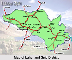
Lahaul and Spiti District is one of the biggest districts of Himachal Pradesh with its headquarters at Keylong. This district is having an international boundary with Tibet. The valleys, mountains, glaciers, rivers, forests, pastures, and monasteries and ancient buildings of the former ruling dynasty are the principal objects to be explored in Lahaul and Spiti District. The entire district is full of natural scenery to explore.
History of Lahaul and Spiti District
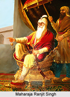 History of Lahaul and Spiti District deals with the reign of Maharaja Ranjit Singh. As per researchers, the two units of Lahaul and Spiti District that are Lahaul and Spiti have separate historical backgrounds. In the distant past Lahaul had been changing hands between the rulers of Ladakh and Kullu. In the second half of the seventeenth century with the disintegration of Ladakh kingdom, Lahaul passed into the hands of the Kullu chief. In 1840, Maharaja Ranjit Singh took over Lahaul along with Kullu and ruled over the region till 1846 when the area came under the sway of the British rulers.
From 1846 to 1940, Lahaul formed part of the Kullu sub-division of Kangra District and was administered through the local jagirdars or thakurs. One of the thakurs was was invested with the judicial and executive powers. Another thakur was given the status of a Revenue Officer. These functionaries exercised traditional as well as other power conferred by the government. The Assistant Commissioner of Kullu used to visit the area once a year for a month or so. In the late thirties the unprecedented prosperity of the people and their consequent awakening created a formidable challenge to the power and influence of the thakur of Lahaul, which gradually started declining. The inadequacy was soon noticed by the government which considered the extension of the regular system of administration. Accordingly in 1941, a separate sub-tehsil comprising Lahaul and Spiti was formed and a naib-tehsildar was posted at Keylong thereby divesting the thakurs of their powers. The system remained in vogue till June, 1960 when Lahaul and Spiti district came into being. Simultaneously, Lahaul was constituted into a separate tehsil, and, later on it was formed into a sub-division.
The British East India Company took over the possession of the Spiti portion in the year 1846 as a result of the Anglo-Sikh War. Before that it formed a part of Ladakh, a subsidiary of Jammu and Kashmir. Because of its remoteness and poverty of natural resources, the British following the example of the Ladakhi rulers, did not introduce any substantial changes in the administrative set up of the territory. The Wazir of Spiti (re-affirmed by the Spiti Frontier Regulations of 1883) and was supposed to represent British India Government. He collected the land revenue for the Government, his judicial jurisdiction included trial of all criminal cases, except cases of murder; and he performed all functions and enjoyed all necessary powers for the fulfillment of his tasks and duties, as laid down in the regulations of 1883.
In 1941, Spiti, with Lahaul, was constituted into a separate sub-tehsil of Kullu sub-division which had its headquarters at Keylong. Later on, after the formation of Lahaul and Spiti into a district, in 1960, Spiti was formed into a sub-division with its headquarters at Kaza.
Geography of Lahaul and Spiti District
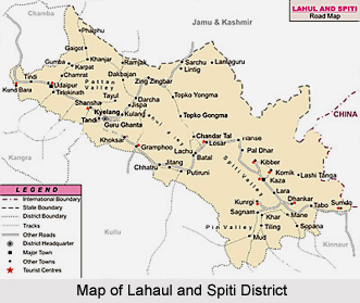 The valley of Lahaul is situated to the south of Ladakh. For this very reason this place derived its name "Lho-Yul" meaning `Southern Country`. To its south is situated the beautiful valley of Kullu across the Rohtang Pass (3195 metres) and the Bara Bangahal (Kangra) across the "Asakh" pass (5051 metres). Its western boundaries touch Pangi and Churah areas of Chamba District. To its north situated are the valleys of Zanskar and Ladakh across Shingola (5090 metres) and Baralacha la (5450 metres) respectively. Its eastern and south eastern boundaries coincide with those of Spiti and Western Tibet across the Kunzom Pass (4500 metres). Since the valley is situated in rain shadow area, north of the Pir Panjal ranges, the weather remains pleasant and quite comfortable during summer season that is from May to mid October. This is the best season to visit this valley. It seldom rains, and the Mercury level does not exceed 30 degree Celsius and never falls below 15 degree Celsius throughout the period. One can always enjoy bright sunshine wandering within lush green valley. There is little or no rain in monsoons. The climate remains dry and invigorating. The days are hot and nights are extremely cold. During winter season that is from November to April it snows heavily because of western disturbances and the temperature goes down below minus. There is an average annual snow fall of about 7 feet.
Culture of Lahaul and Spiti District
The customs, myths, beliefs and conventions of the simple people are the unique features of this border highland. Every village or a hamlet has a prayer flag fluttering over the Buddhist monastery. These shrines are the centres of the cultural life of the people that have influenced their religious beliefs for centuries and round which their social life revolves.
Administration of Lahaul and Spiti District
 Administration of Lahaul and Spiti District is headed by the Deputy Commissioner. Due to single line administration in the district, he is not only the District Magistrate and Collector but for all intents and purposes is also the head of all the district level offices.
In addition to the usual and traditional role as Deputy Commissioner he has multifarious duties. As Deputy Commissioner, he is the executive head of the District looking after development, Panchayats, local bodies and civil administration. As District Magistrate, he is responsible for the maintenance of law and order and is the head of Police and prosecuting agency in Lahaul and Spiti District.
Further, as Collector he is at the apex of the revenue administration and is responsible for the collection of land-revenue and all dues recoverable as arrears of land-revenue. He is also revenue-applause authority. He ensures the successful execution of plan-schemes and co-ordinates the functions of all development departments and his functions are largely those of a Development Officer. In order to avoid procedural delays and in the interest of early disposal of work, he has been given special and enhanced powers. He has been declared Head of Department for all offices functioning in Lahaul and Spiti District.
In addition the Deputy Commissioner has been invested with so many other administrative and financial powers. He can influence transfers of the administrative staffs within the district in respect of staff of all the departments. The Deputy Commissioner is also the disciplinary authority in the district. He can order any punishment, short of dismissal and removal from service. This arrangement has been made to ensure smooth working in the area because of its remoteness. The concentration of powers in the Deputy Commissioner is primarily to ensure the speedy disposal of work and execution of development schemes. These arrangements have worked very well.
There are two tehsils and two sub-divisions in Lahaul and Spiti District namely Lahul and Spiti which are coterminous. The Deputy Commissioner in the district is assisted by additional ministerial and executive staffs. Three Sub-Divisional Officers (Civil) each posted at Keylong, Udaipur and Kaza are invested with powers of Sub-Divisional Magistrate and Collector. The two Tehsildars posted in Keylong tehsil and Kaza tehsil have the powers of the Executive Magistrate and Assistant Collectors of 1st grade. They have to assist the Sub-Divisional Officers both in Magisterial and in revenue work. Tehsildars in turn are assisted in-the revenue work by the field revenue staff. There is no town in the district and entire population is rural. Number of villages in Lahaul and Spiti District is 521 (inhabited 265 and uninhabited 256). Number of Panchayats in Lahaul and Spiti District is 41 and there are two Panchayat Samitis.
Fairs of Lahaul and Spiti District
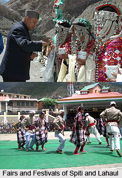 Fairs of Lahaul and Spiti district resonates the collective sagacity of celebration of the cultural life and the ethnicity customised in the soil and ambiance of the region. They add bricks to the gala festering spirit, the jollity, fete, revelry and spree of the region.
The simple rustic people are fond of celebrating each and every moment of life. In remote regions when winter promises regular life to a standstill, the fairs, festivals and events brings the fun and frolic. Thus, these festivals and events are inseparable parts of Lahaul and Spiti.
Fairs of Lahaul and Spiti district resonates the collective sagacity of celebration of the cultural life and the ethnicity customised in the soil and ambiance of the region. They add bricks to the gala festering spirit, the jollity, fete, revelry and spree of the region.
The simple rustic people are fond of celebrating each and every moment of life. In remote regions when winter promises regular life to a standstill, the fairs, festivals and events brings the fun and frolic. Thus, these festivals and events are inseparable parts of Lahaul and Spiti.
The festivals and events in Himachal Pradesh reflect the culture and traditions of Himachal Pradesh. They are the venues for singing and dancing, buying and selling, and, meeting and greeting for the simple Himachali people.
Ladarcha Fair
Ladarcha Fair witnessed its unfurling ground at Kibbar Ground in Spit in the month of July where traders from Ladakh, Rampur Busher and Spiti used to meet in this fair to barter their products and thus indulge in the premeditator assortments of the bygone time shift. Due to closure of business transaction of the Tibetan traders, the current times observe the fair celebrated at Kaza, the headquarters of Spiti Sub Division in the 3rd week of August. A large number of visitors and traders from Kullu, Lahaul and Kinnaur meet there which has now advanced to be converted into a convergence as well as conference of cultures of Spiti, Ladakh and Kinnaur as also of the Indian plains.
Parui Fair
Parui Fair has its magnanimous celebration during the months of summer in the third week of August every year. This fair used to be the most prominent among the other fairs of Lahaul where rustic folks irrespective of all casts and creed gathered not only from Lahaul but from Chamba and Kullu too. The fair demarcates the synthesis of pilgrimage and festive activities. Preparations are made at least a week in advance and most of the people leave their homes a day before the celebrations for the darshan of the idol of Triloknath (Lord Shiva of Three Worlds) or Avolokiteshvara as it is regarded by Buddhist. After paying their obeisance, the people visit parikrama gallery between the inner and outside walls of temple. Pilgrims or devotees usually complete three or seven clockwise circumambulations of the gallery or the rotating the prayer wheels and murmuring Mantras every morning and evening till they stay there. An ambience of holistic spirituality provokes the religious consciousness of the people as Ghee and mustard oil lamps are lighted inside incessantly. People even donate money and Ghee or Oil to maintain the lamps, one of which is so big as to accommodate 16 Kgs. of Ghee or oil. After the completion of prayer and rituals, the fair begins with pomp and glory. For the relaxation and breaks a wide range of temporary shops, tea stalls and hotels are established at the fair ground. As soon as darkness dawns upon there is an aura of spiritual festivity in a huge circle to the melody of folk songs devotional or otherwise. On the second morning, a traditional procession is taken out, which is headed by the Thakur of Triloknath riding on a tinted horse. Their targeted destination is the region where as per the traditional lore, seven gods, and the youngest of whom was Trilokinath had appeared from seven springs in the past. This thrives to be the most important ritual of the fair. The precession then returns to the fair ground for further festivities. Some people for their native places leave as soon as the procession disperses, while others stay until the third day when the fair is over.
Keylong Fair
Tribal fair of Keylong coinciding with Independence Day is celebrated with great pomp and show from 14th to 16th August, at Keylong the headquarters of the district. People from each and every nooks and corner of the valley congregate in their queer disposition and a large number of Indian and foreign tourists assemble here to witness the fair. It is being celebrated as at State level fair. In order to make the fair colourful, artists and cultural troupes are invited from Chandigarh, Dharamshala, Leh Chamba, Kullu, Spiti in addition to local artistes.
Tsheshu Fair
Tsheshu Fair is celebrated in Shashur Monastery, Gemur Monastery, Kye Monastery, Kardang Monastery, Tabo Monastery and Mane Monastery in the months of June. A large number of devotees and people gather on these occasions. Devil dance is performed by the Lamas bedecked in colourful dresses and wearing masks of different birds and animals.
Monasteries in Lahaul and Spiti
 There are different monasteries in Lahaul and Spiti and these are as follows:
Guru Ghantal Monastery: The monastery was founded by Padma Sambhava and is more than 800 years old. The peculiar characteristic of the monastery is the wooden idols as discriminated from the soil idols found in other monasteries. This monastery is positioned on a hill over the Tupchiling village at the meeting of the rivers Chandra and Bhaga.
Shashur Monastery: Shashur Monastery is located at a distance of nearly two kilometres from the region of Keylong, in the Lahaul Spiti district. The architecture of this monastery is a pure reflection of the gothic style of architecture.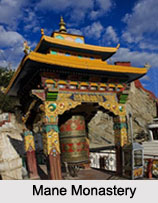
Kardang Monastery: The monastery is located on the left bank of the river Bhaga just over the village of Kardang. It was founded about 900 years ago and stood in ruins up to 1912 when Lama Norbu of Kardang repaired it.
Kungri Monastery: The Kungri gompa was built about 1330 AD. It offers unique proof of tantric sect as practised in Buddhism. Kungri gompa is the main hub of the Nyingma-pa sect in Spiti.
Kibber Monastery: The monastery in Kibber which is named after Serkang Rimpochhe of Tabo. The amazing characteristic about the architecture of this gompa is the use of stone in its place of mud or adobe brick used widely in the valley.
Shashur Monastery: Shashur monastery was founded in the 17th C. AD by Lama Deva Gyatsho of Zangskar. In the month of June or July Chhame (local folk dance) is executed in the monastery which is the most well-liked Chham in Lahaul.
Gozzangwa Monastery: The Gozzangwa Monastery is situated in Khardong Village, Lahaul-Spiti district. It possesses a gompa which is dedicated to Lama Gozzagwa as well as some beautiful rock carvings which belong to pre-Christian period. One might opt to visit Shashur Monastery and Khardong Monastery which are based nearby.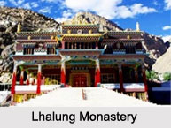
Hansa Monastery: Hansa Monastery is present in Spiti Valley. Kungri Monastery, Kibber Monastery and Kye Monastery are the nearby monasteries that can be visited if one pays a visit to Hansa Monastery.
Lhalung Monastery: Lhalung Monastery is located in Lahaul and Spiti district of Himachal Pradesh. It also holds the difference of being one of the earliest monasteries to be founded in Himachal Pradesh. The temple was founded by the great Rinchen Zangpo, who ruled the western Himalayan kingdoms of Zanskar, Guge, Spiti and Kinnaur during the late 10th century.
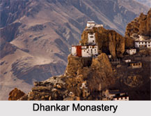
Some of the other Buddhist monasteries like Dhankar Monastery, Tabo Monastery, Kye Monastery, Tayul Monastery and Mane Monastery are some of the many monasteries which are present here.
Temples in Lahul and Spiti
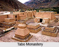 The district of Lahul and Spiti lies in the state of Himachal Pradesh. It constitutes the two erstwhile separate districts, Lahul and Spiti. The present headquarters is in Keylong, situated in Lahul. The district in cut off from the rest of the country, surrounded by lofty mountains and low valleys on the Indo-Tibet border. Lahul and Spiti cover an area of 12,210 sq. km. with varying altitudes. Religion comprises a combination of Hinduism and Tibetan Buddhism of the Drukpa order, accompanied by Tibetan Buddhism of the Gelugpa order. Lahul possesses temples like Triloknath, where pilgrims worship a specific god in different manifestations, particularly in the form of Shiva and Avalokiteshvara. Prior to the arrival of Tibetan Buddhism and Hinduism, people were supportive of the religion `Lung Pe Chhoi`, an animistic religion that had affinities with the Bon religion of Tibet. The Losar festival (also known as Halda in Lahuli) is celebrated between the months of January and February. The date is however decided by the Lamas. Losar bears same significance as Diwali is for the Hindus. Raw scenic grandness and Buddhist monasteries, like Ki, Dhankar, Shashur, Guru Ghantal and Tayul gompas are regarded the primary attractions of the region. Another illustrious place is the Tabo monastery, housing prized collection of scriptures, thangkas (a painted or embroidered Buddhist banner, hung in a monastery or a family altar and occasionally carried by monks in ceremonial processions) and Buddhist statues. Another prominent gompa is the Kardang monastery, located at an elevation of 3500m, across the river, 8km from Keylong. Other admired tourist attractions in Lahul and Spiti include- Baralacha Pass, Kunzum Pass, Pin Parvati Pass, Tashigang Gompa, Pin Valley, Chandra Tal Lake and Suraj Tal.
Triloknath Temple, Lahul and Spiti, Himachal Pradesh : 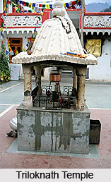 Triloknath Temple is a medieval shrine, situated 4km from Udaipur Village, on the left bank of the Chenab River in Lahul and Spiti district, Himachal Pradesh. The temple enshrines a 12th century, six-armed, white marble idol of Lord Shiva. Udaipur Village is located 50km northwest of Keylong, the district headquarters. This unusual temple is a handsome intermingling of Buddhist monasteries and Hindu temples, considered hallowed both for the Hindus and Buddhists. Triloknath Temple is noted for its delicate carvings, gracing the inner walls and doors. Tibetan prayer flags, built in pagoda style of architecture, deck the entrance of the temple. The tower of Triloknath temple is chiselled from stone. The temple courtyard houses a tiny stone Nandi (the divine bull) and a granite shivling (phallus, symbolic representation of Lord Shiva). There are two brilliantly carved stone pillars on each side of the door, known as the pillars of `dharma` and `paap` (virtue and sin). Triloknath temple also houses prayer wheels, archetypal to Buddhist gompas. Pauri festival, celebrated in August, amidst much spectacle and grandeur, attracts massive crowd from far and near.
Markula Devi Temple, Udaipur, Lahul and Spiti, Himachal Pradesh : Markula Devi Temple goes back to Ajayvarman`s reign. The wood carvings of this temple belong to two different periods, the earlier one consisting of the facade of the sanctum sanctorum and the ceiling and four main pillars of the mandapa; and the later one consisting of two additional pillars, the dwarpala statues on both sides of the facade, window panels and the architraves supporting the ceiling. The ceiling consists of nine panels of different size and shape. The facade of the temple is most richly, elaborately and intricately carved. This unique shrine is the last wooden temple built fundamentally in the region. This is a must visit place.
Mahakala Vajra-bhairava Temple, Lahul and Spiti, Himachal Pradesh- Illustrious for its horrific effects, Mahakala Vajra-bhairava Temple can be accessed after deep meditation only, shrining Buddhist almighty.
Tabo Monastery, Tabo Village, Lahul and Spiti, Himachal Pradesh- Tabo Monastery is the principal monasterial establishment in Lahul and Spiti, home to several other smaller gompas.
White Temple, Lahul and Spiti, Himachal Pradesh- White Temple is adorned with intricate figures, functioning under the Tabo monastery establishment.
Vairocana Temple, Lalung, Lahul and Spiti, Himachal Pradesh- Vairocana Temple enshrines an uncanny 4-faced image of Vairocana, another form of Buddha.
The Temple of the Enlightened Gods, Kaza, Lahul and Spiti, Himachal Pradesh- Temple of the Enlightened Gods is known by several names, with Buddha serving as the presiding deity in a variant form.
Mystic Mandala Temple, Lahul and Spiti, Himachal Pradesh- One of the Tabo Monastic establishments, Mystic Mandala Temple is bejewelled with murals, surrounded with Bodhisattvas.
Geypan Temple, Sissu, Lahul and Spiti, Himachal Pradesh- Geypan Temple houses the patron lord of Lahul Valley, enlaced with elaborate carvings.
Golden Temple, Tabo, Lahul and Spiti, Himachal Pradesh : Golden Temple is one of the temples under the Tabo Monastery administration. The temple is also known as Serkhang. It is conceived that the temple was once covered with gold, hence the name. The walls and ceiling of the Golden Temple are finely dressed with murals. This brilliant shrine was profoundly restored by Senge Namgyal, ruler of Ladakh during 16th century. The temple provides a very peaceful and spiritual environment. It welcomes all types of religions to seek blessings. Golden Temple can be reached by bus, available from Kaza.
The Large Temple of Dromton, Tabo, Lahul and Spiti, Himachal Pradesh- The second largest religious institution under the Tabo Monastery, Large Temple of Dromton is decorated with delicate woodwork.
Tayul Monastery, Keylong, Lahul and Spiti, Himachal Pradesh- Enshrining a colossal statue of Guru Rinpoche, Tayul Monastery also houses a priceless library with ancient relics.
Mane Monastery, Mane, Lahul and Spiti, Himachal Pradesh- Built in medieval times, Mane Monastery is home to several incalculable occasions and artefacts.
Kungri Gompa, Attargo-Pin Valley, Lahul and Spiti, Himachal Pradesh- The sanctum of Kungri Monastery is ornamented with elaborate engravings, regarded as the second oldest gompa in the district.
Gozzangwa Monastery, Khardong, Lahul and Spiti, Himachal Pradesh- Visitors are attracted to Gozzangwa Monastery basically due to its sculptures of the pre-Christian period along with priceless relics.
Gungri Monastery, Pin Valley, Lahul and Spiti, Himachal Pradesh- Gungri Monastery being one of the erstwhile establishments, is home to rare Buddhist sects, founded by Padmasambhava.
Hansa Monastery, Hansa, Lahul and Spiti, Himachal Pradesh- Situated close to popular tourist destinations, Hansa Monastery is also no less attractive in its being one.
Khardong Monastery, Keylong, Lahul and Spiti, Himachal Pradesh- Emblematic of a hill construction, Khardong Monastery is a medieval creation, home to several Buddhist collections.
Kye Monastery, Kaza, Lahul and Spiti, Himachal Pradesh- Withstanding cruel attacks from oppositions, Kye Monastery has survived ravages of time since its built during the medieval age.
Tashigang Gompa, Lahul and Spiti, Himachal Pradesh- Tashigang Gompa is considered exceptionally sacred by the Buddhists in every aspect of their religious faith.
Thang Yug Gompa, Kaza, Lahul and Spiti, Himachal Pradesh- Thang Yug Gompa is a prehistoric monastic establishment, located 13km from Kaza, in Lahul and Spiti district in Himachal Pradesh. The monastery is situated in an isolated place, in the narrow gauge of Kaza Nallah. The gompa usually features a Lama from Tibet. Thang Yug Monastery can be reached by bus from Kaza.
Dhankar Monastery, Dhankar Village, Lahul and Spiti, Himachal Pradesh- With Vairocana as the commanding deity, Dhankar Monastery is home to spectacular Buddhists artefacts.
Shashur Monastery, Keylong, Lahul and Spiti, Himachal Pradesh- Founded in 17th century, Shashur Monastery is home to renowned festivities, built in an extraordinary three-storey format.
Trekking in Lahaul and Spiti District
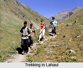 Trekking and Lahaul and Spiti District is a mind boggling experience and the entire experience falls within the ambit of adventure tourism Keeping in view the altitude of the place and the various factors related to it, trekking has been categorised into two broad categories, i.e., the low altitude trekking and the high altitude trekking.
When it comes to the low altitude trekking the trekking activity is restricted below the borders of the snow line, whereas in the latter type a trekker finds himself crossing high passes, snow fields, difficult terrain and camping at rarefied sounds. This particular thing necessitates the grand mastering of several techniques and accurate acclimatisation and equipment to necessarily avoid the circumstantial mishaps and occasional mountain sickness. This does not necessarily point towards the fact that trekking should be construed to be climbing or mountaineering.
Climbing is a specific field requiring intensive training and sophisticated equipment and trekking is only a first step towards that direction. However, there` is no denying the fact that some experience of rock climbing proves good in high altitude trekking. Proper information of mountains, glaciers, valleys and a complete knowledge of these are sure enough to make trekking an immensely enjoyable and educative exercise.
Tourism in Lahaul and Spiti District offers the travellers to explore its museums, art galleries and forts. Some of these are also the trekking spots. The scenic beauty of the surrounding nature adds charm to the tourism experience in Lahaul and Spiti District. Keylong Museum, Pin Valley National Park, Suraj Taal, Chandra Taal, Rohtang Pass, Trilokinath Temple, Markula Devi Temple, Kunzam Pass and Kye Monastery are some of the main attractions of this district. All these sites are worth exploring.
Earlier lack of roads and very limited knowledge about Lahaul deterred people from undertaking trekking and climbing expeditions in this beautiful area. In the past these expeditions could not materialize for want of road communication up to the base camps. Now equipment and rations can be carded in the automobiles right up to the base camps. Rations like dehydrated and tinned foods, mineral water, etc. are easily available in Keylong at cut-throat economical rates. With the creation of infrastructural facilities the Lahaul valley offers all sorts of opportunities to explore the region. Much will depend on the taste, interest and aptitude of the individual. One thing is certain that Lahaul`s magnificent peaks, snow serpents, i.e., glaciers, awe inspiring precipices, spectacular gorges, blue water lakes, refreshingly verdant valleys, potato fields, alpine-Himalayan Flora and fauna , mystique monks, monasteries, its myth, legend, folklore and a totally different tribal culture would leave an indelible inkling on the minds of the visitors.
The best trekking season in the Lahaul valley is between July and October. Because of climatic and geographical factors trekking in the Lahaul valley requires detailed and careful planning.
Though numerous schools and colleges and various government and private agencies and organisations have started conducting trekking and hiking tours in the Indian Himalayas, trekking continues to be a low-key activity. When compared to Nepal, trekking in India is unorganised and uncontrolled activity. The north-eastern states, Kumaon and Garhwal hills of Uttar Pradesh, Jammu camp; Kashmir and Himachal Pradesh attract a sizeable number of Indian as well as foreign trekkers, but the potential has not been fully exploited. As far as Himachal Pradesh is concerned, trekking is confined to Shimla, Dharamasala, Chamba and Kulu districts. Manali has given a much required impetus to this activity. Kinnaur has been able to attract trekkers from far and wide after vigorous advertisement campaigns launched by Himachal Tourism Department. Lahaul continues to be one of the most neglected trekking regions despite a plethora of trekking routes. The flow of Indian trekkers is almost negligible. Most of the trekking in Lahaul is being done by the local clubs.
Almost two thousand foreigners visit this valley every year during the open season or the holiday season. The trekking programmes of the foreigners are mainly confined to the classic trekking routes to Padum in the Zangskar region of J&K. Some of them trek to Chandra-Taal via Darcha and by the Baralacha la. From Chandra Taal they usually go to Manikaran in Kullu district. Some choose Myar valley for going to the Zangskar region or the Pangi valley in Chamba district. Rarely do they take trekking routes from Lahaul to Chamba, Mani Mahesh and Dharamasala.
Tourism in Lahaul and Spiti District
 Some of the main attractions of Lahaul and Spiti District are as follows -
Keylong Museum: One of the main attractions of Lahaul and Spiti District is Keylong Museum. This museum of Tribal Art along with an auditorium is being established at Keylong. The museum apart from archaeological finds displays Thanka Paintings, objects of everyday use that existed before the achievement of modern mechanised equipments in the region. The museum is also having manuscripts in Bhoti Scripts and Tankri documents. The museum is also having a good auditorium for hosting cultural events. The museum is under the control of Department of Language Art and Culture.
Pin Valley National Park: It is another popular tourist spot of Lahaul and Spiti District. It is located in the Pin valley of Spiti at height of 12,000 metres above sea level. It is home to several endangered species.
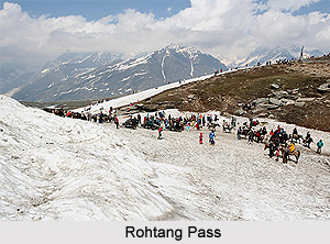
Rohtang Pass: Rohtang pass (altitude 13050 feet) separates Kullu, from the exotic charm of the Lahaul valley. To the left of this pass is the little lake Sarkund. Several religious beliefs are associated with this lake.
Suraj Taal: Suraj Taal or the lake of Sun god is situated well on the summit of the Baralacha Pass, a little below an altitude of 16000 feet.
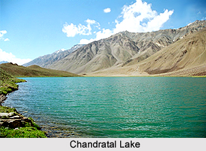
 Chandra Taal: This natural lake is situated at about 14,000 feet above mean sea level. The lake lies in a broad grassy plain which in ancient times was a glacier. The lake is about a km in length and half of it in breadth. It is a beautiful tourist spot.
Spiti: Spiti possesses a memorable beauty. The wildlife in the region is really diverse offering huge scopes for exploring. Spiti has come to be known as the `fossil park of the world`.
Kaza: Kaza makes an ideal base camp for all treks and tours within the valley.
Kunzam Pass: This pass is situated at 60 kms from Gamphu on the Gramphu-Kaza- Sumdo road. It provides chief access to the Spiti valley from Lahaul. Though higher than the Rohtang Pass, Kunzom is safer and provides easier ascent and descent. The altitude of this pass is about 4590 metres above mean sea level. The panorama as viewed from the top is breathtaking.


