Home > Travel > States of India > Kodagu District
Kodagu District
Kodagu District is a district situated in the Karnataka, in south India.

Share this Article:

Kodagu District, Karnataka 
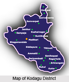
Kodagu District is a region of steep mountains. It is the name of the district in south India in Karnataka.

The word Kodagu is derived from `kudu` (Kannada language) meaning steep or hilly and `Krodha-desa` taken from in the Puranas, meaning `Land of Anger`. It is also said that Kodagu is derived from the word `Kodava` Kod means `give` and avva means `mother` which is mother Kaveri, the Kaveri river.

History of Kodagu District
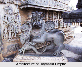
Kodavas were the most primitive agriculturists in Kodagu District. Over centuries several South Indian dynasties, like the Kadambas, the Gangas, the Cholas, the Chalukyas, the Rashtrakutas, the Hoysalas, and the Vijaynagar Rayas, ruled over Kodagu. Kodagu District was the kingdom of the Hoysalas ruled from the 11th to the 14th century. The land was ruled by the Haleri Rajas of Kodagu from the 17th to the 19th century. Between 15th and 17th century Kodagu was ruled by Mysore Sultans who invaded this region. In 1834 the Britishers took possession of Kodagu District removing the last Haleri Raja. After independence Kodagu District became a district of Karnataka State.

Kodagu District, KarnatakaGeography of Koldagu District
Kodagu District is a region formed by the summits of the Western Ghats. It is about sixty miles in length and forty in breadth. It comprises and occupies around one thousand five hundred and eighty five (1,585) square miles. Kodagu is endowed with a charming variety to the landscape.

Economy of Kodagu District
Kodagu District is covered by forest and is an ideal area for agriculture. There are coffee plantations, or ragi patch, or the park like open glades with their beautiful green sward and varied foliage. Kodagu is also a native land for a number of tribes like the Yeravas, Kurubas, Airies and Kudiyas.

This article is a stub. You can enrich by adding more information to it. Send your Write Up to [email protected]


Share this Article:

Related Articles

More Articles in States of India


East Indian States
East Indian States comprises of Bihar, Jharkhand, West Bengal, Odisha and also the Union Territory of Andaman and Nicobar Islands. It defines the cultural heritage, rich historical background and the linguistic unity.
Erode District
Erode District is one of the districts in the state of Tamil Nadu. The district of Erode is having a land-locked area with no sea coast.
Purnia District in Bihar
Purnia District is located in Bihar and extends from River Ganga to Nepal. The district has a rich Hindu history and glorious past.
South Delhi District
South Delhi District is the third largest district of Delhi as far as its area is concerned. South Delhi District is known for its economic, historical, cultural and social significance.
North Indian States
North Indian States formed the cultural and religious unity in spite of having many foreign invasion and the political disturbances from the early era till the British gained supremacy in Indian sub continent.
Kendujhar District
Kendujhar District, spread over an area of 8,240 sq kms, is as varied as the whole of Orissa with waterfalls roaring gorges, mountains and minerals. The manifold expressions of nature in Kendujhar District are considered as unique.
Hooghly district
Hooghly District along the bank of the river Hooghly is one of the principal trading ports of West Bengal.
Districts of South Tamil Nadu
Districts of South Tamil Nadu consist of many tourism destinations like archaeological sites and the history of Pandyas and Cholas. Considering their proximity to the sea, many districts also boast of serene beaches and coastal beauty.
Flora of Arunachal Pradesh
Flora of Arunachal Pradesh includes infinite species and is a subject of great interests for the botanists.
Districts of South Gujarat
Districts of South Gujarat are the epicenter of Jain pilgrimages and the early Hindu kingdoms.
North West States of India
North West States of India consist of three states, which are Rajasthan, Punjab and Haryana. All of them are culturally and traditionally diverse and they have been ruled by different dynasties in historical time.
Geography Of Chittoor District
Geography of Chittoor district is spread along the topography of the land which is divided into two natural divisions; Chittoor has a dry and healthy climate.
Districts of North Rajasthan
District of Northern part of Rajasthan is dotted with ancient forts and medieval villages.
Districts of North Odisha
District of North Odisha has Bengal boundary and shares the same culture. These are reachable if one pays a weekend visit to Digha.
Districts of West Bihar
Districts of West Bihar is comprised of medieval monuments that were built by the different governors of Mughal era.
Districts of South Haryana
Districts of South Haryana consists of many cities of industrial excellence. These districts are dotted with popular tourism destinations.
Medieval History of Assam
Medieval history of Assam narrates the advent and rule of a number of kingdoms in the region. The prominent dynasties of the kingdom left an everlasting imprint on the socio cultural heritage of India.
Geography of Meghalaya
The suitable climate, highland plateaus, rivers and the flora and fauna together forms the geography of Meghalaya.
Districts of Rayalaseema
Districts of Rayalaseema in Andhra Pradesh state has urban population and rural settlements as well.
Districts of South Punjab
Districts of Southern part of Punjab depict medieval history of Punjab and the rise of Sikhs.