 Indian Rivers have immense significance in the lives of the citizens of the nation. They are the sources of drinking water and support the livelihoods of a large number of people and flora and fauna in India. Often referred to as the "land of rivers", India has been blessed with several water bodies, which enhance the beauty of the country. Indian rivers are part of mythology, religion, culture and history of the country. They also contribute to the economy of the country by promoting development of various power projects.
Origin and Course of Indian Rivers
Indian rivers originate from the mountains. Three primary watersheds of Indian rivers are formed by three groups of mountain ranges namely, the Himalayas and Karakoram ranges; the Vindhya Mountain Range, Satpura Mountain Range and Chota Nagpur Plateau; and the Western Ghats Mountain Range in India. Twisting between the valleys, the Indian rivers come down to the plains and nourish the lands, making them fertile. Some rivers empty themselves in the Arabian Sea and some join the Bay of Bengal at the end of their course. There are rivers in India which end up forming inland drainage basins within the country.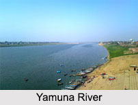
Classification of Indian Rivers
Indian rivers can broadly be divided into Himalayan Rivers, Deccan Rivers, Coastal Rivers and Inland Drainage Basin Rivers. Rivers associated with Indian mythology are known as mythological rivers. Some of these rivers are Rupa, Pampa, Oghavati Dhritamati and Saraswati River.
Himalayan Rivers
Millions of people depend on the rivers that run through the several states of India and originate in the Himalayan mountain range. The Indus, Ganges, and Brahmaputra are three of India`s principal Himalayan Rivers. These rivers, which provide water for irrigation, transportation, and power generation, are nourished by the snow and glaciers of the Himalayas.
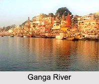
Before entering Pakistan, the Indus River travels through the states of Jammu and Kashmir, where it has its source in Tibet. The Ganges, the most sacred river in India, rises in Uttarakhand in the Himalayas and runs through West Bengal, Uttar Pradesh, and Bihar before joining the Bay of Bengal. Before flowing into Bangladesh, the Brahmaputra River leaves Tibet and travels through the states of Arunachal Pradesh, Assam, and Meghalaya. Teesta River originates from the Tso Lhamo Lake in the North Sikkim district and is considered the right bank major tributary of the Brahmaputra river system.
The Ghaggar River has its source in the Shivalik Hills in the Himalayas and meanders through the Morni Hills before reaching the plains located near Panchkula. It is an important river in the northern region of India, and its course has been a significant factor in the development of the regions along its banks. Other major Himalayan rivers include Ravi river and Chenab river.
The Yamuna, Sutlej, Ramganga, and Kali Rivers are three other significant Himalayan rivers in India that start in the Himalayas and pass through a number of states. They are also known as rivers of the Garhwal region. In India`s economy and ecology, the Himalayan Rivers are vital. A wide variety of aquatic life, including numerous endangered species, can be found there as well.
Deccan Rivers
The Deccan plateau in southern India covers a sizable area and is home to numerous rivers that pass through the area. Among India`s most important Deccan rivers are the Godavari, Krishna, and Kaveri, also known as Cauvery. These rivers are nourished by the rainfall that blesses the area, and they are a vital supply of food for the Deccan`s agriculture-based economy.
Originating from the Western Ghats in Maharashtra, the Godavari River flows through several states including Telangana, Andhra Pradesh, and Odisha before emptying into the Bay of Bengal. The Krishna River, which also originates in Maharashtra, flows through Karnataka and Andhra Pradesh before finally reaching the Bay of Bengal. The Kaveri River, another essential Deccan river, originates in Karnataka and flows through Tamil Nadu and Puducherry before ultimately joining the Bay of Bengal.
Apart from these major rivers, several other vital rivers such as the Tungabhadra, Bhima, Kabini, and Pennar, originate in the Deccan region and flow through multiple states, providing support for various communities and ecosystems. The river Mahanadi is considered the lifeline of Chhattisgarh and is counted among the major rivers in Deccan India. These rivers are integral to the region`s economy, ecology, and culture, and it is essential to ensure their sustainable management and conservation for the well-being of the communities that rely on them.
Coastal Rivers
Numerous rivers in India originates and travel across its various coastal regions are a blessing. For the communities live along their paths, India`s coastal rivers are the main source of irrigation, transportation, and power generation. The Narmada, Tapti, Mahi, Sabarmati, Periyar, and Pamba are India`s principal coastal rivers.
The Narmada River originates from the Maikal Hills in Madhya Pradesh and flows through Gujarat and Maharashtra forming several valleys among its course before emptying into the Arabian Sea. The Tapti River originates from the Satpura Range in Madhya Pradesh and flows through Maharashtra and Gujarat before finally joining the Arabian Sea. The Mahi River originates in Madhya Pradesh and flows through Rajasthan and Gujarat before finally emptying into the Arabian Sea. The Sabarmati River, originating from the Aravalli Range in Rajasthan, flows through Gujarat and joins the Arabian Sea near Ahmedabad
The Periyar River, originating from the Western Ghats in Kerala, flows through the state before finally joining the Arabian Sea. The Pamba River, another significant coastal river in Kerala, originates in the Sabarimala hills and flows through the state before finally joining the Arabian Sea. These coastal rivers play a crucial role in the economy, ecology, and cultural heritage of the regions through which they flow. The rivers provide essential resources to communities residing along their course, and it is crucial to manage and conserve these rivers for the sustainable development of the coastal regions of India.
Inland Drainage Basin Rivers
The inland drainage basin of India is a distinctive area with a number of rivers that begin or merge there. Due to the absence of outflow pathways to the sea, this region is characterized by the development of enclosed basins where water is lost by evaporation or seepage into the earth. The Luni, Sambhar, and Sindh are three of the principal rivers in the inland drainage basin.
The Sagarmati River, also known as the Luni River, is one of the most popular rivers in India`s inland drainage basin. Its source is in Rajasthan`s Aravalli Range. The river flows across the Thar Desert and finally merges into the marshy Rann of Kutch. The Sambhar Lake, the biggest inland saltwater lake in India, receives water from a number of rivers including the Sambhar River, which rises in the Aravalli Range and empties into the lake.
The Sindh River, which originates in the Western Himalayas and flows through Himachal Pradesh, Jammu & Kashmir, and Punjab, is another significant river in the interior drainage basin. As an important tributary of the Indus River, it eventually merges with it in Pakistan. The ecology, culture, and way of life of the areas through which they flow are significantly influenced by the interior drainage basin rivers.
Religious Significance of Indian Rivers
Most of the Indian rivers are considered to be holy and are worshipped by the Hindus. Ganga River is the holiest of all rivers in India. Most of the religious places in northern India are either situated on the banks of Ganga River or nearby. The holy water of the Ganga is used for worshipping the gods of India. It is believed that the sacred Indian rivers have the prowess to wash away all the sins of a person.


