Introduction
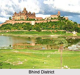
Bhind District is northernmost district of Madhya Pradesh with its headquarters at Bhind town. This administrative district is situated at 25 degree 54 minutes 5 seconds north to 26 degree 47 minutes 50 seconds north latitude and from 78 degree 12 minutes 45 seconds east to 79 degree 8 minutes 30 seconds and 79 degree 8 minutes 30 seconds east longitude. Bhind District lies in the valleys of Chambal River and the Sindh, between Kwari River and Pahuj River. Total area occupied by Bhind District is 4459 sq kms.
History of Bhind District
History of Bhind District tells that the United State of Madhya Bharat was formally inaugurated on 28th of May, 1948 at Gwalior State. Later, it was decided to divide the Union into six districts and Bhind was one among them. As a result of reorganisation of states on the formation of Madhya Pradesh in November, 1956, Bhind District became a part of newly formed state of Madhya Pradesh. Further, according to the history of Bhind District, during the time of Bharata war the entire region between valleys of Yamuna and the Vindhyas.
As per the history, Bhind District is named after Bhindi Rishi. Bhind District. It is a well known fact that the region has been subjected to depredations of dacoits, robbers or thugs since ages. Even during Mughal times the powerful administration failed to curb these menace.
According to the Puranic tradition, Manu`s grandson Pururavas Aila, founder of lunar race, extended his sway into the Gangetic doab. Malwa and Eastern Rajputana, covering most probably Bhind district also. His great grandson King Yayati is said to have reduced the whole of Madhyadesha and the surrounding region. After him, his son Yadu became a mornarch of the territory that was watered by Chambal River, Betwa River and the Ken River. The Yadus were supplanted by the Haihayas, who were again annihilated by the Yadus of Vidarbha. Kanishka became the king of this region. Thus, Bhind District evidently lying in the area came under Aryan fold.
In the 4th Century AD, the whole of Aryavarta was incorporated in the vast empire of the Nandas. According to the Puranic evidences, Mahapadmananda the founder of Nanda Dynasty was the destroyer of all the Kshatrapas and the sole monarch of the earth. The distributions of the inscriptions of Ashoka inscriptions indicate that in the 3rd Century BC he was the master of a vast empire, embracing the whole of India excepting the four states of extreme south, Ashokan inscription at Gujar (in the adjacent Datia district) testifies the close association of the Mauryan emperor with this region.
In the first century AD the Gwalior region was under the rule of earlier Nagas. Padmavati, city in the Vindhya Hills (in Gwalior District), Mathura and Kantipuri (Morena District) were the headquarters of the three branches of the Naga rulers. Later the Kushanas supplanted the Nagas. Kanishka was the greatest of the Kushana emperors, His Empire extended over Madhyadesha, Uttarapatha and Aparanta regions of ancient India stretching from Bihar in the east to Khorasan in the west and from Khotan in the north to Konkan in the south. Bhind District thus, was included in the Kushana Empire. The downfall of Kushana Empire was complete in this area after the reign of Vasudeva. Their place was taken up again by the Nagas, who remained politically prominent in this area during the 3rd and 4th centuries AD,took up their place again.
In the middle of the 4th century AD the Naga territory passed under the Gupta sovereignty. During the reign of Bhanugupta (AD 495 - AD 510), or shortly before his accession, invasion of the Huns leader Toramana hastened the dissolution of the Gupta empire. The Huns Empire included the territories from Punjab to Central India; even brought Magadh, Kaushambi District and Kashi under their sphere of influence. As per history of Bhind District, in the beginning of the 7th century AD, Harshavardhan ascended the throne of Thaneshwar and became the king of Kannauj. During this dynasty Jainism flourished in the region.
By the second quarter of the 8th century AD, this region along with Malwa came under the dynastic rule of a branch of the Gurjara Prathiharas. Moreover, Vajradaman conquered Gwalior fort for Dhanga about 977 AD. After that his dynasty ruled over Gwalior region till the earlier part of the 12th Century AD.
History of Bhind District also mentions about the Sultanate period. This region then passed under the Delhi Sultanate. In the year 1195 - 1196 Muhammad Ghori attacked Sallakshanapala, the Pratihara chief of Gwalior Sallakshana accepted Ghori`s suzerainty and was therefore allowed to rule his territory.
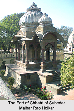
This region later came under the sway of the Sur Dynasty. The District of Bhind formed most part of the Sarkar of Agra in the Subah of Agra. The district comprised mainly the Mahal of Hatkant which had a brick fort. The Mughal rule continued till the beginning of 18th Century AD. The town of Gohad, which is now part of Bhind district, was founded by a Jat family. The tract around this town was captured by the Jat family in the latter part of the 17th Century AD. In about 1736 AD, the Maratha army led by Baji Rao I, attacked the Raja of Bhadawar, and after putting him to flight, devastated his territory. Again in 1737, Malhar Rao Holkar attacked the territory of the Raja of Bhadawar and besieged his stronghold.
History of Bhind District also includes the post Mughal dynasty period. From this period, the history of Bhind District coincides with that of Gwalior tract. Daulat Rao Scindia died in 1827 and was succeeded by Mugat Rao alia Jankoji Rao, a minor on adoption. He was succeeded by Jayaji Rao. After the revolt in 1857, Gwalior was attacked by the combined forces of Lakshmi Bai, Rao Saheb and Tatya Tope in 1858. The British then stormed the Gwalior fort and took it under their control on June 18, 1858. It was passed over to the Scindia in March 1886. The Gwalior Light railway from Gwalior to Bhind was constructed in 1897 and was started in 1899. After the independence of the country, United State of Madhya Bharat was formally inaugurated by Jawaharlal Nehru in the year 1948 at Gwalior.
Geography of Bhind District
The shape of Bhind District is semi circular, bulging towards the north east. The greatest length of Bhind district measures about 105 km south east to north-west. Bhind District is bounded by Agra and Etawah district of Uttar Pradesh in the north and Gwalior District and Datia district in the south. The eastern boundary is closed by Auraiya District and Jalaun of Uttar Pradesh in the east, where as the western and north western boundaries are common with Morena district.
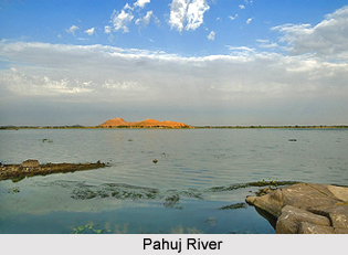
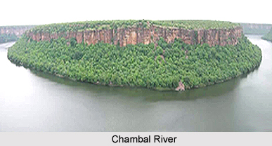
The north western boundary is marked by the Asan and the Kwari rivers, the northern and eastern boundaries being traversed by Chambal River and Pahuj River. The soil of Bhind District is very fertile and is well drained by the Chambal and Sindh rivers and the tributary streams of the Kwari and Pahuj. Bhind District mainly consists of valley plains.
Geography of Bhind District mainly consists of valley plains. The plains at present are closely cultivated fields devoid of trees, stubbed with shrubby growth only along the moist hollows, and thickly populated. The network of rivers with deep channels and steep bank offers the only divisions of topography. The widest plane of Bhind District lies in the western part around Gohad, Mehgaon and Mau.
The ravine lands extend along both the sides of the rivers and their tributaries. The ravine areas are mostly unsuitable for cultivation and settlements. The entire district lies in the Chambal River valley. It forms the south-western part of Ganga River Valley. The Hills are only a few, small and isolated, mostly in the southwest. Bhind District of Madhya Pradesh is geographically known for its ravines, fertile land and dense forests. It is only in the Bhind Tehsil that the rivers flow towards east.
Geography of Bhind District also includes a number of rivers and streams. Chambal River and Sindh River are the main rivers of the district. The Chambal forms the northern boundary. As the two rivers are the tributaries of Yamuna River, they form parts of the Ganga drainage system. Apart from these, the other important rivers of the district are Kwari River, Pahuj River, Asan River and Vaishali River.
The climate of Bhind District is characterized by general dryness, except during the south-west monsoon season. The year may be divided into four seasons. The winter season is from December to February followed by the summer season from March to about middle of June.
The period from middle of June to about the end of September is the south-west monsoon season. October and November constitute the post-monsoon or retreating monsoon season. Average annual rainfall of Bhind District is 668.3 mm. The spatial variation of the district is not too much. About 92 percent of the annual rainfall is received in the south-west monsoon months. On an average, there are 33 rainy days in a year.
There is no meteorological observatory in Bhind District. After February, the temperature increases steadily till May, when the mean daily temperature is about 46 degree Celsius and the mean daily minimum is about 28 degree Celsius. In June, the mean daily temperature is higher by a couple of degrees. The heat in the summer season is intense and the dust laden scorching winds, which blow often, add much to the discomfort. With onset of monsoon in the district by the mid of June, there is an appreciable drop in the temperature. After October, day and night temperature decrease rapidly. January is the coldest month with the mean daily maximum temperature at about 23 degree Celsius, and the mean daily minimum at about 8 degree Celsius. In the cold season in the rear of passing western disturbances, cold waves affect Bhind District and the minimum temperature may drop down to about a degree below the freezing point of water.
Culture of Bhind District
Culture of Bhind District is rich and diverse. The popular languages spoken in the district are Hindi language, Punjabi language, and Urdu language. Several festivals are celebrated in Bhind District with huge enthusiasm. Dussehra, Diwali, Holi and Muharram are the four most important festivals celebrated in the district. Makar Sankranti, Raksha Bandhan, Ramnavami, Shivaratri, Ganesh Chaturthi, Janmashtami, Id-ul-Fitr, Nag Panchami, etc are other festivals of the district.
Demography of Bhind District
The sex ratio is the number of females per 1000 males. As per 2001 Census, total population of Bhind District is 1,428,559, out of which male population is 7, 80,902 and female population is 6, 47,657. Sex ratio is the number of females per 1000 males. Population density is 320 persons per square km. Bhind District is holding the 20th position in terms of population as it is having about 2 percent of the total population of the state. Rural sex ratio is 825 and Urban is 843. Bhind district had population of 1,703,562 of which male and female were 926,940 and 776,622 respectively. It was the data revealed in 2011 population census. The data of teh census in 201 shows that density of Bhind district for 2011 is 382 people per sq. km. The Average literacy rate of Bhind in 2011 was 76.59.
Economy of Bhind District
Economy of Bhind District is based in the agriculture. Agriculture is the main occupation of the people in the district and dairy is the main supplementary source of income of the farmers in the district. The soil is fertile, and the district is well drained by the Chambal River and Sindh River and the tributary streams - Kwari River and Pahuj River. The district can be credited with a high percentage of the net sown area. Traditional cropping practices along with old conventional tools are still used commonly but the farmers have readily adopted the improved models of the traditional tools or the new agricultural machinery as well.
Bhind Canal Project has literally been the backbone of the district irrigation since long. It was constructed back in the year 1919 and was completed by 1933 under the erstwhile Gwalior State regime. Tank and wells are used to irrigate in the district.
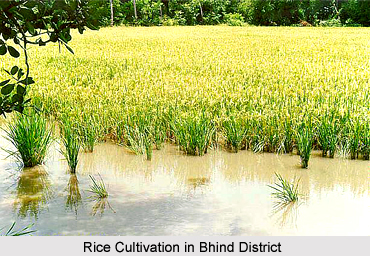
Both Rabi and Kharif crops are cultivated in the district. Rabi cultivation has gained significantly along with increase in irrigation in this area. In Kharif crops, the development of certain crops like rice and bajra has given particular attention and has registered progress. This growth of Kharif crops has evidently been due to decreasing popularity of other food crops consisting mostly of millets, which had earlier occupied a much larger area together under them.
Animal husbandry is another sector of economy of Bhind District. Further, poultry farming in this area was formerly limited more or less to some particular communities and generally in the economically weaker sections. With the increasing popularity of eggs, poultry farming is now being pursued by larger section of the population in the district. Moreover, near about 417 small scale industries have been established through District Industry Centre, Bhind. Around 2340 people are employed in these industries.
Ghee manufacturing in Bhind is an important industry, along with rearing of livestock for milk and other milk products. Most of the industrial activities in Bhind District are concentrated at Bhind. In order to attract new entrepreneurs a scheme of establishing a Semi-Urban Industrial Estate was launched at Bhind during 1962 - 1963, where in developed plots and constructed sheds were provided to industrial units. Most of the large and medium scale industries are located at Malanpur. The economic importance of the local forests is limited to fuel only.
Tourism in Bhind District
Tourism in Bhind District offers several sightseeing options for the travellers. It includes visits to those places having historic as well as religious importance. Tourism in Bhind District gives a memorable and enriching experience to the people who come from all parts of the country. Some of the major tourist attractions of Bhind District are mentioned below -
Fort of Ater: It was built by Bhadauria King Badan Singh, Maha Singh and Bakhat Singh in the era 1664-1668. After them the area is known as `Badhwar`. It is located deep inside the ravines of Chambal. Now it is in a dilapidated condition. Fort of Ater is located 35 kms in the west of Bhind city. The main attractions of the fort are `Khooni Darwaza`, `Badan Singh Ka Mahal`, `Hathiapor`, `Raja Ka Bangla`, `Rani Ka Bangla` and `Barah Khamba Mahal`. Another fort situated in Bhind city was also built by Bhadoriya King to keep control over rebellions in the era 1654-1684. During Scindia reign Darbar hall was constructed in which at present a museum is conducted by District Archeological Association Bhind.
Vankhandeshwar Temple: It is located in Bhind town. This temple is dedicated to Lord Shiva and was built by Prithviraj Chauhan in 1175 AD.
Jain Temples of Baranso: These are really old temples and are located on Bhind Gwalior Road, 5 kms south east of Bhind.
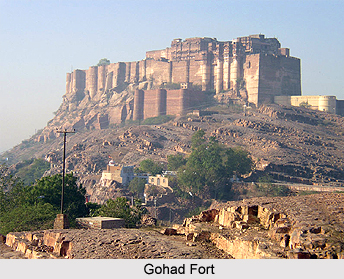
Gohad Fort: It is located in Gohad near Mau and is told as the birthplace of Parasurama. Folklore linked to Parasurama says that his father ordered to cut the head of his mother Renuka, which he obeyed and as a prize asked for revival of his dead mother which Maharshi Jamdagini, his father solicited. The temple was built at the place of this activity.
Naraddev Temple: It is a temple of Lord Shiva located on the banks of Sindh River. It is old and Lord Narad worshipped here. It is being renovated.
Fort of Gohad: Jat King Maha Singh built the Fort of Gohad. The fort is dilapidated but a part of it is still housing several government offices. The fine carvings of this fort are worth viewing. The "Kachheri Mahal" is a unique example of the Iranian Art.
Apart from these places, the world famous ravines of Bhind District are the places worth visiting. Five rivers which flow around the district mainly Pahuj River, Sindh River, Kwari River, Chambal River and Yamuna River meet together in an area of 2 kms named as `Pachnada`. Shiv Mandir Daang and Fort of Gohad are other two prominent places of interest in Bhind District.
Road transport is the main mode of transportation in Bhind. In this district, roads serve 27.26 percent villages. The railway line connects Bhind with Gwalior.


