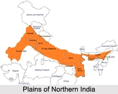
 Plains of Northern India, also known as Indo-Gangetic Plain or the North Indian River Plain, are a flat and enormous plain. These plains extend in the east-west direction and are bounded in between the Himalayan in the north and Great Indian Peninsular Plateau in the south. These plains form an unbroken belt of alluvium varying in thickness from east Bihar Plain to Punjab and northern Rajasthan. Sutlej Plain in the west, the Ganga Plain in the middle and the Brahmaputra Plain in the east constitute the Plains of Northern India.
The Thar Desert in India is located in the west of the Aravalli Mountain Ranges being largely a plain formed partly by corrosion and partly by deposition is also included in the Plains of Northern India. These plains continue to the west beyond Punjab and Rajasthan and merge into the Indus Plains in neighbouring country Pakistan.
Extension of the Plains of Northern India
Plains of Northern India, also known as the Gangetic Plains, is situated in the southern Himalayan Region. The Northern Plains spreading from Assam to Punjab has a length of around 2400 km and the width ranges between 150 km to 300 km, varying in different regions. It can be found in Bihar, Punjab, Assam, West Bengal, Uttar Pradesh, parts of Delhi and Haryana.
 Features of Plains of Northern India
Plains of Northern India are consistently level plains without any interruption except for a few outliers of the Aravalli Mountain Range, such as, in the environs of Delhi. Formerly deep trenches of around 6 to 8 km in depth, these plains outline the isolated low hills or ridges and come out of the adjacent alluvium as islands in the ocean. The trench was formed as a fore deep, when the Himalayas rose as fold mountains. This east-west depression received drainage from the Himalaya Mountains in the north and the plateau in the south.
Owing to continued silting, the depression was filled up with sediments. Stability in the level of these plains is mainly due to two basic facts. Firstly, no earth movement disturbed their flatness later and secondly the deposition took place in water. The watershed that divides the Sutlej Plain from the Ganga Plain is low as one enters the Haryana-Punjab Plain from the Uttar Pradesh Plain.
Division of Plains of Northern India
The Plains of Northern India are generally divided into 3 river systems-
The Sutlej plain drained by the Indus,
The Ganga plain drained by the Ganga and
The Brahmaputra valley drained by the Brahmaputra.
Sutlej Plain
Less than 1/3rd of the Indus basin is situated in India (Jammu and Kashmir, Himachal Pradesh and Punjab). It is approximately 2900 km long and its primary tributaries include the Sutlej River, Beas River, Ravi River, Chenab River and Jhelum River. These rivers unite together before finally merging the in the Indus River. These rivers have turned the Plains of Northern India pretty productive and it now bears the testimony of the densest systems of irrigation canals.
 The Sutlej Basin is situated in the west of the Northern plains covering Haryana, Punjab, as well as parts of Chandigarh. Beas, a tributary of Sutlej, adjoins the river at Harike. In the Sutlej Basin, crops like wheat, sugarcane, rice, gram, oil seeds and cotton are cultivated. Rice and wheat, 2 of the major crops are supplied from here, to the rest of the country.
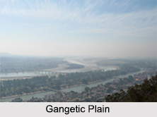
Ganga Plain
The major portion of the Plains of Northern India consists of tile Ganga basin. It extends from the eastern margin of the Punjab in the west to Bangladesh border in the east. This is an extensive plain encompassing Indian states such as Uttar Pradesh, Bihar and West Bengal.
Ganga River has two primary origins in the Himalaya the Bhagirathi River and the Alaknanda River. Both merge in Dev Prayag and flow as the Ganga afterward. It enters the northern plains at Haridwar. Yamuna River joins it in Allahabad. Chambal River, Sindh River, Betwa River and Ken River in turn join the Yamuna River. They all stream through the Malwa Plateau before entering into the northern plains. The Son River is the only big river that joins Ganga immediately from the southern plateau. Further east, the Damodar River, irrigating the entire region of Chota Nagpur Plateau, joins the Hooghly River, another tributary of the Ganga River.
The Himalayan Rivers uniting with the Ganga downstream of Allahabad from west to east comprise of the Gomti River, Ghaghara River, Gandak and Kosi River. The Ganga forms a great delta on its mouth.
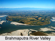
Brahmaputra Plain
Brahmaputra initiates in Tibet near the source of the Indus River and Sutlej River. Brahmaputra River is longer compared to the Indus, most of its course lying in Tibet. It streams parallel to the Himalaya Mountains in Tibet, where it is referred to as Tsangpo. In Arunachal Pradesh it is called Dihang. After the convergence of the Lohit River, Dihang and Dibang River, it is named the Brahmaputra. Leaving a huge volume of water, it also transports a gigantic amount of silt with it accumulating debris which paves the way for a fertile land with alluvium soil.
Composition of Northern Plains of India
Plains of Northern India have been formed by the deposition of alluvia brought by the rivers. The main rivers of the region bring it down from the Himalayas in the north and the peninsular plateau in the south. Such a plain is also termed as alluvial plain that is rich in alluvial soil. The rivers being heavily charged with boulders, sand and mud unexpectedly loosen in speed as they debouch on these plains depositing their load in the form of gravel fans along the foot of the Himalayan ranges.
The southern edge of the Gangetic Plain is broken by several gorges turning the productive alluvial land into unusable barren waste lands. In states of Punjab, Haryana and Uttar Pradesh, which is fed by deficient rain, the main rivers of the region have been tapped for irrigational purposes.
The Plains of Northern India are very essential and have their great contribution in the economic development of the country. The land, being even, has stimulated and sustained the growth of improved transportation and communication system.


