
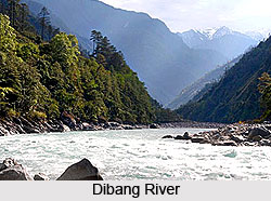
 Dibang River is an important tributary of the Brahmaputra. It flows through the northeast Indian states of Arunachal Pradesh and Assam. The Dibang Valley, a district of Arunachal Pradesh, is named after this river.
Origin and Course of Dibang River
The exact location of the origin of this river is 27 degree 49` 60 N and 95 degree 31` 60 E. The demographic area type of Dibang River Valley is Hydrographic. The river goes through its middle course across the lower Dibang valley district of Arunachal Pradesh. The Dibang River and Lohit River merge together and flow along the northern side of the Saikhowa Reserve forest. Iphipani Ghat is 10 km from the Roing Township and is situated very close to the river. The region all along the upper course of the river is located in the Great Himalayan Mountain Range, with its northern and eastern reaches bordering Tibet. The Mishmi Hills is found along the upper courses of the Dibang River. The Mishmi Hills is the southward expansion of the Himalayas; compose most of the northern part of the region. They have an average elevation of 15,000 feet (4,500 m) and are dotted with passes such as Yonggyap at 13,000 feet (3,950 m) and Kaya at 15,600 feet (4,750 m). The Dibang, along with other rivers like Ahui, Adzon, Emra, and Dri streams flows southward to join the Brahmaputra River.
Attractions of Dibang River
The famous Bhismaknagar Fort stands at the foothills of the mountains between the Dikrong and the Dibang rivers. The fort is known for its architecture. Fabricated from the burnt bricks, the architecture displays the primeval culture. Subtropical evergreen forests of oak, juniper, maple, and pine cover the hilly vegetation of the region.
Hydro Projects on Dibang River
Former Prime Minister Manmohan Singh laid the foundation stone for a 3000 MW dam as part of the Dibang Multipurpose Project in the district of Lower Dibang Valley in 2008. Government has also proposed seventeen other dams with power potential between 20 and 4500 MW for the Dibang. It is believed that the proposed Dibang dam, at 288 metres, on completion would be among the largest dams in India.









