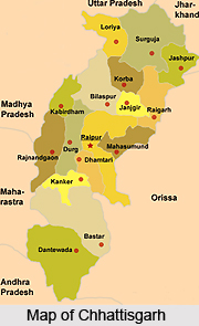
Introduction
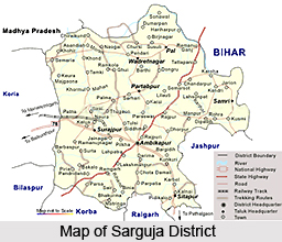
 Surguja District is located in the northern part of Chhattisgarh. Uttar Pradesh, Jharkhand, Orissa and Madhya Pradesh are adjoining to Surguja District. This district of Chhattisgarh has over extension between south-eastern parts of Vindhyachal-Baghelkhand region of peninsular India. It is located between 23 degree 37 minutes 25 seconds to 24 degree 6 minutes 17 seconds north latitude and 81 degree 34 minutes 40 seconds to 84 degree 4 minutes 40 seconds east longitude. Surguja District has a total area of about 16359 sq km; it is 244.62 km long east to west and 167.37 broad North to South. Ambikapur is the district headquarters.
History of Surguja District
 Surguja District is situated in the northern part of the state of Chhattisgarh in India with the district headquarters lying in the Ambikapur area. The district borders on the states of Uttar Pradesh and Jharkhand, and overlaps the south-eastern part of the Vindhyachal-Baghelkhand region of peninsular India.
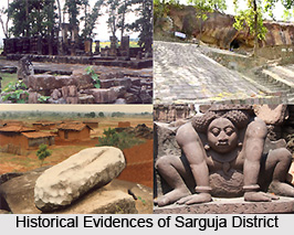
The presence of various temples stone carvings and archaic remains show the evidence of existence of this region before Christ (BC). In 4th BC before the arrival of Maurya Empire, this region was in the Lord of Nanda clan. Before 3rd BC this region was divided into tiny parts. Further, it was undertaken by Rajput kings belonging to Rakshal clan in Palamau, Bihar. In 1820 Amar Singh took control over Surguja state who had been crowned as "Maharaja" in 1826. In 1882 Raghunath Sharan Singh Deo had taken his control over Surguja state.
According to some holy books, Lord Rama had visited Surguja during his 14 years of exile period. There are many places associated with Ramayana. Many places are named after Lord Rama, Laxmana and Sita; these are Ramgarh, Sita-Bhengra and Laxmangarh.
Princely State of Surguja
The Princely State of Surguja was amongst main states during the rule of the British Empire in India. During the early 19th century, the region was appointed as one of the princely states of India under the indirect rule of the British administration. The state covered a total area of 6,055 sq miles and comprised of a total population of 551,307 in the year 1941. Presently, the district of Surguja is located in the northern region of the Chattisgarh state, India. Ambikapur serves as the headquarters of the district. The district is bounded by the modern states of Jharkhand and Uttar Pradesh and overlies the south eastern region of the Vindhyachal Baghelkhand region of peninsular India.
The Princely State of Surguja was a part of the Chhattisgarh States Agency in the Eastern States Agency. It was the largest state in the Eastern States Agency and was bordered by the erstwhile British United Provinces of Agra and Oudh in the north; by the British Province of Bihar in the north-east; by Jashpur in the south-east; by Udaipur in the south; by the British district of Bilaspur (Central Provinces and Berar) in the south-west; by Korea in the west and by Rewa in the north-west.
History of Princely State of Surguja
The Princely State of Surguja came under the protection of the British Government of India in the year 1818, after the Third Anglo Maratha War. It is considered that Surguja state operated as the overlord of the current states of Jashpur, Udaipur, Changbhakhar and Korea. The 5 states of the Surguja group, along with Gangpur, Bonai, Kharsawan and Seraikela, were previously known as the Tributary Mahals of Chhota Nagpur. In the year 1891, the British administration decided that these territories were not included as a part of British India and revised sanads were officially issued in 1899. This recognized these regions as feudatory states and defined their associations and links with the British Empire in India.
The hereditary title of the native ruler of the princely state of Surguja was Maharaja, who exercised full administrative and jurisdictional powers and authority. An advisory committee consisting of 3 members was established in the year 1944 on the initiative of the ruler. The state was one of the original constituent members of the Chamber of Princes, a number of smaller states indirectly represented by 12 princes who were elected periodically by them. In 1940, the Maharaja of Surguja was admitted to the Chamber in his own right.
Geography of Surguja District
 Surguja District Surguja District lies between 23 degree and 37 minutes and 25 second to 24 degree 6 minutes17 seconds north latitude and 81 degree 34 minutes 40 seconds to 84 degree 4 minutes 40 seconds east longitude. 244.62 kilometres (152.00 mi) long east to west and 67.37 kilometres (41.86 mi) broad north to south, this land has as area of about 16,359 square kilometres (6,316 sq mi).
When it comes to the delineation of the geography of Sarguja District, the high-lands of Surguja district are characterised by peculiar `pat formations` which are but the highlands complimented with small tablelands. Several small areas mark the topographical chart of the place as for example Mainpat, the Jarang pat, the Jonka pat, the Jamira pat and the Lahsunpat that thrives to be the major parts of the district. The average height of area is above 600 metres (2,000 ft). Some of peaks are - Mailan 1,226 metres (4,022 ft), Jam 1,166 metres (3,825 ft), Parta Gharsa 1,159 metres (3,802 ft), Kanda Dara 1,149 metres (3,770 ft), Chutai 1,131 metres (3,711 ft), and Karo 1,105 metres (3,625 ft). There are a number of other peaks. North-west Surguja is hilly in nature, and moving westwards, three distinct steps may be marked out the first from Srinagar on the east to the lowlands of Patna and Khargawan, the second from thence to the uplands around Sonhat and the third beyond Sonhat to above a height of 1,033 metres (3,389 ft). Central Surguja is a low basin through which the Rihand and its tributaries flow.
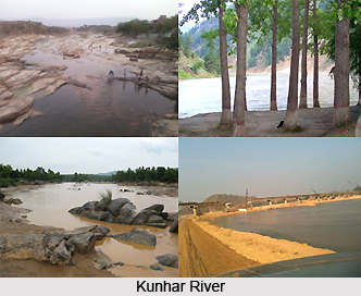
There are three river basins in Suguja district - those of the Hasdeo River, the Rihand River and the Kanhar River. In winters, temperature dips to below 5 øC (41 øF) and in summers, it rises above 46 øC (115 øF). Main rivers of the district are Kanhar, Moran, Rihand River and Mahan. This drainage system is known as southward river system. The general slope of west Surguja is towards south and about 25% drainage comes in this system. Southerly rivers of district are the Hasdo and Gej, which forms the part of the Mahanandi Drainage System. This drainage system is called as southward river system. The general slope of west Surguja is towards south and about 25% drainage comes in this system. Southerly rivers of district are the Hasdo and Gej, which forms the part of the Mahanandi Drainage System.
 Kanhar River starts its journey from Gidha-Dhodha on the Khudia plateau in jashpur tahsil of Raigarh district and flowing northward, forms the eastern boundary of district with Palamau district of Bihar state. This river flows for 100 Kms in district. It is fed by small tributaries - Suria, Chana, Sendur and Kursa on it`s left bank and Galphulla, Semarkhar, Riger and the Cherna nallah on it`s right bank . A number of waterfalls are located along the track of the river. Pavai fall near Kothali village (Balrampur District) is of about 61 meters. A plan for massive Hydro-electricity project was set up here since last two decades.
Rihand River has as Rend or Rehar, rises in the region southwest of the Mainpat plateau, which is about 1,100 meters above mean sea level, from Matiranga hills. The river flows north roughly through the central part of the district for 160 Kms. The Rihand and its tributaries form a fertile plain in the central district stretching around Ambikapur to Lakhanpur and Pratappur. It`s principal tributaries are the Mahan, the Morana(Morni) ,the Geur ,the Gagar ,the Gobri ,the Piparkachar , the Ramdia and Galphulla. A medium irrigation project is working on Ghungutta River, since 1981, near Darima Air Strip under taken by World Bank, Which is about 15 kms from Ambikapur. The Mahan is a perennial river, on which medium Multipurpose project is under implementation as well as consideration by Central water Commission.
Climate of Sarguja District
The climate of district features hot summer and well distributed rainfall during the monsoon season. With its general monsoonal character, the region according to thornthwait`s classification falls in the Tropical Thermal belt assigns it the grassland type character. According to trewartha`s classification, the Surguja falls in AW class, which is based on temperature and vegetation. The symbol AW denotes Tropical Swanah region. The chief feature of this climate is long dry period average monthly temperature rising over 18 0C, through maximum summer temperature may even go up to 46 0C. In winter the temperature not go below 18 degree Celsius .The monsoon bring sufficient rains. The chief determinants of climate in the district are its shape, Size, extent, and Central system of high lands and uplands. The location on tropic of cancer results tropical climate with high-pressure belt throughout the year, but due to its height above MSL controls its high temperature. The district is about 700 km from ocean therefore oceanic effect still remains zero , Whereas it`s location southward of Himalaya about 500 km protects it against cold winds blowing from northern belt.
Physiography of Sarguja District
The Physiography of the Sarguja District is divided into three broad natural divisions- the Mountains, Plateaus and the Central Plain. Physiographically, they are remarkable landforms and difficult to find a large area of one character expects its attitude .Average height of area is varies from 600 meter and more. The highland of Surguja district is peculiar `pat formations`. The major peaks of the district are as under: The Mainpat, the jarang pat, the jonka pat, the jamira pat and the Lahsunpat are the major pats of the district. The Uplands (Plateaus and hills): The terrain of northwest Surguja region is marked by hilly areas and there the roads move westwards. Three distinct steps may be marked out the first from Srinagar on the east to the lowlands of Patna and Khargawan, the second from thence to the uplands around Sonhat and the third beyond Sonhat to above the height of 1,033 metres. The Central plain and lowlands includes the topography central Surguja assume the form of low basin through, which the Rihand and its tributaries flow. This low-level basin is in form of inverted triangle.
Culture of Surguja District
 Culture of Surguja District is basically influenced by the tribal traditions and religious beliefs of the region. Culture of this district of Chhattisgarh is indigenous and very unique. There are several popular traditional dance forms that are performed by the people on certain occasions.
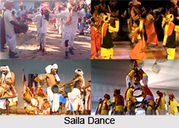
Saila Dance
This Saila Dance is performed on several occasions, like, in any popular public functions, National festivals, Vijay rallies of any political leaders, etc. Only male members participate in this dance. Dance is performed in a group, all of them holding two hard bamboo sticks in their hands; strike the sticks of the adjacent persons, either of his right or left, which also make a sweet sound. They have a unique interval of striking the sticks so that sound of the sticks should come out together. Participants are dressed in traditional attires like dhoti-kurta and pagdi. The dance is also performed in the month of January at the end of cutting of crops.
Suwa Dance
 The aim of this dance is to please the goddess of the wealth and also to express the thoughts of hearts of young marriageable girls. They dance in every house of the village and at the owner`s house also who provides them rice, paddy or money, as to thank goddess. Their songs carry a touchy meaning and the effect is that whenever a marriageable young boy listens this song and watch a young girl dancing he puts a proposal before his parents. And the parents of the boy send a message via a messenger about the desire of their son. And the consent of the parents of the girl results in their marriage.
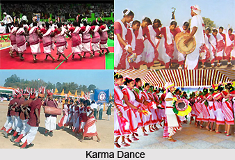
Karma Dance
There are different types of Karma dance. The dancing system is recognized by the various cast groups. Urban tribal have their system of dancing. Male and female are chained together and form a circle in the dance. The name Karma is drawn from the name of a tree Karma. The branch of a tree is carried by the dancers and is passed among them while singing and dancing. This branch should not touch the earth. It is washed with milk and rice bear. Then it is taken in the middle of the dancing arena. All members of the caste dance for whole night in the praise of the karma. According to some legends, Karma tree is a symbol of good luck and fortune.
Surguja District has a deep culture of songs and dances. These dances constitute a significant part of the fairs and festivals celebrated in Surguja District.
Minerals of Surguja District
 Mineral Resources of the Surguja District in actuality; projects the mineral belts of the region which are not only the mineral belts only but even the source of revenue earning for the district. Firstly the Upper catchments of river or Sitapur-Samri belt which is associated with eastern and south eastern part of the district. It is proliferated in Bauxite and some amount of Coal. Secondly Central-North Surguja (Wadrafnagar-Pal-Pratappur-Surajpur-Ambikapur) belt. The reserve of coal, Pyritic minerals, Sulphur, Mica Berylluiim, Byrites, Copper, Galena are reported. Bishrampur, Bhatgaon, Tatapani, Ramkola, Lakhanpur and Basen are main coal fields. Some Fire-clay, Mica, Coal, Galena, silmenite are also reported in Wadrafnagar on Uttar Pradesh border.
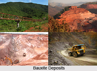
In the district of Surguja, Bauxite deposits have been found in tertiary rocks from times immemorial. It is due to decay and weathering of aluminium rich rocks, Felspar usually kaoliniesd under the tropical monsoonal condition as the weathering goes a step further and result in residua rich in hydroxides of aluminium together with oxides of Iron, manganese and titanium sufficient contraction of aluminium hydroxides, economic deposits of bauxite originates.
 This process of `Bauxitisation` as it is called thrives well on topographically elevated well drained plateaus of low relief. The recoverable reserves of bauxite in Surguja are 57.54 million tones, which is around 57% of total state reserve.
Out of 57.74 million tones, 42.21 million tones are under proved category, 13.56 million tones under probable category and remaining 1.76 million tones under are possible category. About 51 million tones of the total reserves are of metallurgical grade and the grade particular of 6 million tones are not known. The economical deposits are located at entire pat (local name given to plateau or pleatux) region of eastern and south eastern Surguja including Mainpat, Samari and Jamirapat. Mainpat Bauxite is of good and thickness varies from 4-5 meters. Chemical composition is Jamirapat & Samripat. Bauxite deposits of these areas are metallurgical grade I. These two major reserves are centred in Samri tahsil and adjacent plateaus - Jamripat, Jaranpat, Lahsunpat, Jonkapat and other small hill rocks.
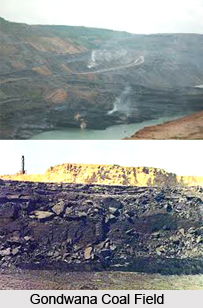
Most of the coal in the Gondwana is found in Barakar series. Coal as a solid stratified rock composed mainly of hydro carbon and capable of being used as a fuel to supply heat or light or both. The coal fields of Surguja belong to Gondwana coal fields. The coal of this area is of good quality stream and gas coals. The coal fields of Surguja can be classified as Middle Gondwana Coal Fields: Tatapani-Ramkola, Jhilmili and Sonhat
Talcher Coal Fields: Bisrampur, Bansar, Lakhanpur, Panchbhaini and Damha-munda.
Mahanadi River Basin: Hasdo-Rampur.
Tourism in Surguja District
 Tourism in Surguja District means a pleasurable and rejuvenating experience. At this district of Chhattisgarh one can find several places of interest. These tourism spots attract visitors from different parts across the globe. Tourism in Surguja District offers pilgrimage, leisure as well as nature tourism options.
Pilgrimage Tourism in Surguja District
Shivpur Shiva Temple
Pratappur is 45 kms away from Ambikapur, village Shivpur is 4 kms from Pratappur. At this temple, big ceremonies are organized on the occasion of Shivaratri and Vasant Panchami.
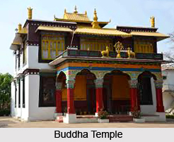
Buddha Temple, Mainpat
Mainpat is called as Shimla of Surguja. Tibetans are rehabilitated at Mainpat, which run small industries of mat (Kalin) and woolen cloths. Buddha Temple is a place to appreciate the art of Buddha vihars and people of Tibet.
Leisure Tourism in Surguja District
Deepadih
A village of Samri Tehsil, it is situated near about 41.6 kms to its southwest. About one and half kms from the village there are a few ruined temples and tanks. According to some historians Deepadih was ruled by a Dravidian monarch, named Samni Singh. In near proximity there is a ruined temple, enshrining an artistic figure of Mahishasura Mardini. Some other gods and goddesses are also sculptured on the pillars along with Saivism emblems of chain, trident snake, etc. and flowers and leaves. A huge figure of Nandi is towards its east. About 50 metres away from this temple there is another ruined pillar in the middle.
Deogarh
A village of Ambikapur tehsil, Deogarh is situated on the bank of the Rihand River amidst calm and quiet scenic beauty. It lies about 1 and half kms to the west of the Bamlaya-Ambikapur Road. From Ambikapur its distance is about 40 kms towards south. There are several mounds, formed by the debris of temples, each crowned with a deity.
Kailash Caves:
Kailash Caves is situated at Sabarbar which is 60 kms to the east of Ambikapur. These caves were created by Saint Rameshwar Gahira Guruji. Temple of Lord Shiva and Parvati several other temples are there in these caves. On occasion of Mahashivratri huge festival is organized here. Major attraction of this place are temple of Lord Shiva-Parvati,Yagya Mandap,Sanskrit school, Gahira Guru ashram,Badgdrat Beir and Badh mada.
Nature Tourism in Surguja District
Ramgarh Hill
A high hill of the district with a peak, Ramgarh lies to the east of the great road from Allahabad to Rameshwaram, in the extreme south. It rises abruptly from the surrounding plains of the former Rampur Tappa of the district.
Pawai Water Fall
This waterfall is situated in Ramanujganj Block and is considered as a famous tourist attraction.
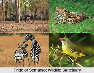
Semarsot Wildlife Sanctuary
The sanctuary is located near Semarsot on the Ambikapur Daltongunj road. Semarsot is about 50 kms from Ambikapur, district headquarters of Surguja District. The area is situated in the northern extension of Ramgarh hills in a north-easterly direction. The area has a border with Bihar in the east.
 Tropic of Cancer passes through the area. The forest types found in the sanctuary are Sal forest, mixed deciduous forest and Riverine forest. The species that generally occur are Shorea robusta, Terminalia alata, Terminalia chebula, Terminalia arjuna Terminalia bellerica, Lagerstroemia parviflora, Anogeissus latifolia, Adina cordfolia, adhuca indica, Emblica officinalis, Butea monosperma, Pterocarpus marsupium, Grewia species, etc.
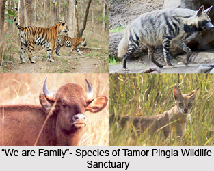
Tamor Pingla Wildlife Sanctuary
The sanctuary is situated in Surguja District bordering with Uttar Pradesh. The sanctuary is about 100 kms from Ambikapur. Sal and mixed deciduous forest types are found in the sanctuary. The important species are Shorea robusta, Pterocarpus marsupium, Terminalia alata, Terminalia chebula, Terminalia bellerica, Terminalia arjuna, Anogeissus latifolia, Diospyros melonoxylon, Diospyros chloroxylon, Emblica officinalis, Soymida febrifuga, Dendrocalamus strictus, Butea monosperma, Bauhinia species cassia fistula, Grewia species, Gymnosporia spinosa, etc.
Temples in Surguja
 Surguja district is located in the northern part of Chhattisgarh state and is entwined with a number of temples. The different temples of Surguja enhances the tourist ratio quite ideally. The district headquarters is Ambikapur. Surguja borders on the states of Uttar Pradesh, Jharkhand, Orrisa and Madhya Pradesh and overlaps the southeastern part of the Vindhyachal-Baghelkhand region of peninsular India. The district is spread across a stretch of 22,327 sq. km. Legends describe that Lord Ram had visited Surguja during his 14 years of exile in the forests. There are many places in connection to the epic of Ramayana, which are named after Lord Ram, Laxman and Goddess Sita, like Ramgarh, Sita-Bhengra and Laxmangarh. Quite ideally therefore temples indeed plays an important part in Surguja and the very presence of varied temples in Surguja further supports the fact.
Mahamaya Temple, Ambikapur, Surguja, Chhattisgarh: Mahamaya Temple is situated in the east of Ambikapur town. It is an extremely revered, ancient shrine belonging to the Kalchuri era. The presiding deity is Goddess Mahamaya, an incarnation of Goddess Durga. According to historical records, the idols of Mahamaya belong to the 2nd or 3rd century. The Samleswari Temple, dedicated to Goddess Samlai, is situated exactly in front of the Mahamaya Temple. Anuppur Junction Railway Station is the nearest major railhead. The temple is quite simplistic in construction, but the effect of worship is praised by every follower who visit the temple to worship the Almighty Goddess.
Samleswari Temple, Ambikapur, Surguja, Chhattisgarh: Samleswari Temple is a very ancient one dedicated to Samleswari Devi, the goddess of learning. It is located just opposite to the Mahamaya Temple. The idol of Samleswari is made out of eight precious metals, dazzling to look at.
Kudargarh, Surguja, Chhattisgarh: Kudargarh is a much-famed pilgrim centre of Surguja. It is 98 km from the district headquarters of Ambikapur, connected by an all weather road. The best time to visit is during Chaitra Navaratra (in the month of April).
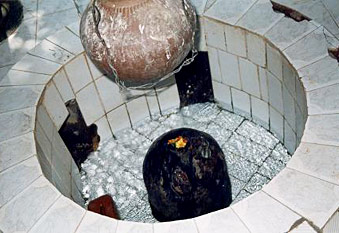
Maa Bageshwari Devi Temple, dedicated to Goddess Kudargarhi, is perched on atop a hill. The history of the temple speaks according to Dalton that the temple was built by Baland Kings. The Balands were the original rulers of the Koriya (Korea) state in 17th century. Bageshwari, however, is famous for its desirous demands. On a successful fulfillment of one`s desires, the goddess is pleased with the blood of a goat. There is a small `kund` (gaping hole), 6 inches in diameter, where the blood is poured, that never is filled up to the brim even if thousands of goats are slaughtered for blood. For this very reason, people from far and near come to visit the goddess.
Shivpur Shiv Temple, Ambikapur, Surguja, Chhattisgarh: The town of Pratappur is 45km from Ambikapur, and the village of Shivpur is 4km from Pratappur. In Shivpur, an ancient Shiva Temple is located, right in the middle of natural atmosphere, i.e. open aired, under the sky. The constructor of the temple is however, not known to anybody. This very unusual feature of this Shiva Temple attracts devotees from far off places. Huge festivals and fairs are organised on the occasions of Mahashivratri and Basant Panchami.
Buddha Temple, Mainpat, Surguja, Chhattisgarh: Mainpat is called the `Shimla of Surguja`. Tibetians, the chief residents of this rehabilitation centre run small industries of designer mats (Kalin) and woolen cloths. For facilitation of their worship, they have constructed a Buddha Temple. They are followers of the Dalai Lama, who have changed the atmosphere of Mainpat to a humanitarian one. This particular Buddha Temple is built in the lines the Buddha Viharas (from Tibet).
Nageshwar Shiv Temple, Kusmi, Surguja, Chhattisgarh: Kusmi is 95 km from Ambikapur and 10km from there on the way to Bhagwanpur, is the Nageshwar Shiv Temple. It is a natural (self-made) temple of Lord Shiva and the shadow created by the snake (`nag`) on top of the idol of Shiva, is the main attraction of tourists. A big festival is organised on the occasion of Mahashivratri.