Introduction
Western Uttar Pradesh is a prominent region in northern India. It includes the historically and culturally rich areas of Rohilkhand and Upper Doab, regions that played a significant role in the development of Hindi-Urdu, one of the major linguistic traditions of India.
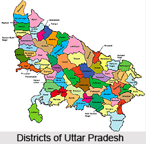
Uttar Pradesh is administratively divided into 75 districts grouped under 18 divisions, and Western Uttar Pradesh accounts for 26 of these districts. These are spread across six administrative divisions - Saharanpur, Meerut, Moradabad, Agra, Aligarh, and Bareilly. Each district functions under the leadership of a District Magistrate (DM) or District Collector, who oversees governance and development activities.
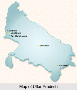
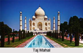
Western Uttar Pradesh is known for its distinct demographic, economic, and cultural profile. This region shares more in common with neighboring states like Haryana and Rajasthan, in terms of social customs, dialects, and even agricultural practices. Ghaziabad, the largest city in this region, stands as a major urban hub and is part of the National Capital Region (NCR). The second-largest city, Agra, is internationally renowned for its architectural marvels, especially the Taj Mahal, making it a key node in India's tourism circuit.

The region has also witnessed substantial economic
transformation, particularly influenced by the Green Revolution, which brought
agricultural prosperity to this belt. Similar to Haryana and Punjab, Western
Uttar Pradesh saw rapid modernization in farming and infrastructure, which
further fueled its economic ascent.
List of Districts in Western Uttar Pradesh
Here is a list of 26 districts in Western Uttar Pradesh with their administrative headquarters.
Saharanpur Division
· Saharanpur district (Saharanpur)
· Muzaffarnagar district (Muzaffarnagar)
· Shamli district (Shamli)
Moradabad Division
·
Bijnor district (Bijnor)
·
Moradabad district (Moradabad)
·
Sambhal district (Bahjoi)
·
Rampur district (Rampur)
· Amroha district (Amroha)
Meerut Division
·
Meerut district (Meerut)
·
Ghaziabad district (Ghaziabad)
·
Hapur district (Hapur)
·
Gautam Buddha Nagar district (Greater Noida)
·
Bulandshahr district (Bulandshahr)
· Baghpat district (Baghpat)
Aligarh Division
·
Aligarh district (Aligarh)
·
Hathras district (Hathras)
·
Etah district (Etah)
· Kasganj district (Kasganj)
Agra Division
·
Agra district (Agra)
·
Mathura district (Mathura)
·
Firozabad district (Firozabad)
· Mainpuri district (Mainpuri)
Bareilly Division
·
Budaun district (Budaun)
·
Bareilly district (Bareilly)
·
Pilibhit district (Pilibhit)
·
Shahjahanpur district (Shahjahanpur)
Saharanpur Division of West Uttar Pradesh
Among the key administrative regions of West Uttar Pradesh, the Saharanpur Division holds significant historical and administrative importance. Established in April 1997, it is one of the 18 administrative divisions of Uttar Pradesh, with Saharanpur city serving as its divisional headquarters.

This division currently includes three districts - Saharanpur, Muzaffarnagar, and Shamli. Historically, the division also included Haridwar district, which later became part of the newly created state of Uttarakhand in 2000. Both Saharanpur and Muzaffarnagar were established well before India’s independence, reflecting their long-standing administrative roles. Shamli, the youngest among them, was carved out of Muzaffarnagar on September 28, 2011, initially named Prabudh Nagar, and later renamed Shamli in July 2012.
The Saharanpur Division is not only important
administratively but also culturally and historically. The region is home to
revered sites such as the Radha Raman Temple, Shakambhari Devi Temple, and the
Hathni Kund Barrage, all of which attract both devotees and tourists alike. In
addition to its spiritual landmarks, the division is emerging as an educational
hub in West Uttar Pradesh. Institutions like Maa Shakumbhari University, Glocal
University, and the Shaikh-Ul-Hind Maulana Mahmood Hasan Medical College
contribute to the region's growing academic profile.
Moradabad Division of West Uttar Pradesh
Situated along the fertile plains of the Ganga River basin, the Moradabad Division plays a vital role in the agricultural and economic landscape of West Uttar Pradesh. Known for its strategic location and rich alluvial soil, the division is a hub of both trade and farming, supporting the livelihoods of thousands of people across the region.

The Moradabad Division consists of five districts- Bijnor, Moradabad, Sambhal, Rampur, and Amroha. The city of Moradabad, serving as the divisional headquarters, is widely celebrated for its intricate brass handicrafts, earning it the nickname "Brass City" or "Pital Nagri." Generations of artisans have sustained this legacy, making brassware production a backbone of the local culture and economy.
Bijnor and Moradabad are among the older districts, established well before India's independence, and have witnessed a long evolution of governance and culture. Rampur district came into existence on December 1, 1949, with Rampur town as its administrative center, known for its rich Nawabi heritage and contributions to literature and music.
Amroha, designated as a separate district on April 24, 1997,
is known for its historical architecture and cultural depth. Sambhal is the
most recent addition, carved out on May 3, 2011, with Bahjoi as its
headquarters. It comprises nearly 993 villages, highlighting the rural fabric
of the region.
Meerut Division of West Uttar Pradesh
The Meerut Division, located in the heart of Western Uttar
Pradesh, stands out as one of the region’s most significant administrative and
economic zones. Encompassing six districts, it forms a vital part of the
National Capital Region (NCR), contributing to both the region’s urban
development and historical legacy. Meerut city serves as the divisional
headquarters and is known for its deep roots in India’s freedom movement and
rich cultural heritage.

The division comprises Meerut, Bulandshahr, Ghaziabad, Baghpat, Hapur, and Gautam Buddha Nagar districts. Meerut and Bulandshahr are among the oldest districts in the region, established long before India gained independence. These areas have played significant roles in India’s history, especially during the 1857 uprising.
Ghaziabad district was carved out on November 14, 1976, and has since evolved into a major urban hub and industrial center within the NCR. Due to its proximity to Delhi, it has seen rapid development in infrastructure and real estate.
Baghpat district, once part of Meerut, was declared a separate district on September 17, 1997. Predominantly agricultural, the district is known for sugarcane cultivation and its contribution to the rural economy of western Uttar Pradesh.
Hapur district was established in September 2011 when the Hapur tehsil was separated from Ghaziabad district. Spanning just 660 square kilometers, Hapur is the smallest district in Uttar Pradesh by area, yet it plays a key role in trade and commerce due to its strategic location.
Gautam Buddha Nagar, formed on September 6, 1997, is a modern district with Greater Noida as its administrative headquarters. The district is divided into three tehsils—Noida, Dadri, and Jewar and was created by merging areas from both Ghaziabad and Bulandshahr districts. Today, Noida and Greater Noida are prominent centers for IT, manufacturing, and education.
The region of Gautam Buddha Nagar district also holds
immense historical and mythological significance. During the freedom struggle,
revolutionaries like Bhagat
Singh, Rajguru,
Sukhdev, and Chandra
Shekhar Azad sought refuge in Nalgadha village. The area is also steeped in
ancient legends. Bisrakh village, located in Greater Noida, is believed to be
the birthplace of Vishrava Rishi, father of Ravana, linking the district to
the epic Ramayana.
Similarly, Dankaur is said to have housed Dronacharya’s
ashram, where the Pandavas and
Kauravas were trained in warfare, tying the land to the Mahabharata.
Aligarh Division of West Uttar Pradesh
The Aligarh Division encompasses the southern part of the Doab
region and consists of four districts- Aligarh, Etah, Hathras, and Kasganj.
Though newly designated as a division, the region holds deep historical,
cultural, and economic significance in Western Uttar Pradesh.

The city of Aligarh, serving as the divisional headquarters, has a storied past dating back to when it was known as Kol or Koil. Over centuries, it witnessed numerous invasions and rulers, each leaving their mark on the city’s architecture and traditions. Today, Aligarh is renowned for two key contributions- its lock-making industry, which has earned it fame across the country, and the prestigious Aligarh Muslim University (AMU), one of India’s oldest and most respected centers of higher learning.
Aligarh and Etah were established as districts before India’s independence, with Etah maintaining its identity as a predominantly agricultural region, contributing significantly to the region’s grain and crop output.
Hathras district was officially formed on May 3, 1997, by merging areas from Aligarh, Mathura, and Agra districts. Originally named Mahamaya Nagar in honor of Mayadevi, the mother of the Buddha, it was renamed to Hathras in 2012. The district is known for its rich cultural fabric and traditional farming practices, with a focus on a variety of crops.
Kasganj, the youngest district in the division, was created
on April 15, 2008. It comprises three tehsils—Kasganj, Patiali, and Sahawar and
has since grown in importance as a center for local trade and rural
development.
Agra Division of West Uttar Pradesh
The Agra Division is a region rich in history, spirituality,
and cultural heritage. Comprising four districts—Agra, Mathura, Firozabad, and Mainpuri, this
division holds immense significance both as a center of tourism and as a place
deeply rooted in ancient Indian traditions.

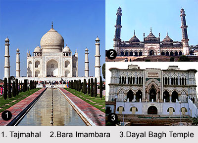
At the heart of the division is Agra district, world-renowned for the Taj Mahal, one of the most iconic monuments in India. The district is divided into six tehsils- Etmadpur, Agra, Kiraoli, Kheragarh, Fatehabad, and Bah. Agra’s blend of Mughal architecture and vibrant marketplaces draws millions of visitors each year, making it a significant part of India's tourism sector.
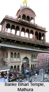
To the north lies Mathura, a city steeped in mythology and devotion. Nestled along the banks of the Yamuna River, Mathura is revered as the birthplace of Lord Krishna, with nearby Vrindavan being the site of his childhood legends. Together, Mathura and Vrindavan are among the most sacred destinations in the Vaishnava tradition, attracting pilgrims from across the globe. Mathura district is organized into five tehsils- Mathura, Govardhan, Chhata, Mant, and Mahavan.
Mainpuri, another district with roots dating back before India’s independence, is part of the ancient Braj region, associated with Lord Krishna’s lore. Predominantly agrarian, the district is made up of six tehsils- Mainpuri, Bhongaon, Karhal, Kishni, Kurawali, and Ghiror. Its quiet towns and rural landscape reflect a deep connection to cultural traditions.
The youngest district in the division is Firozabad, which
was carved out on February 5, 1989. Known today for its bustling glass and
bangle industry, Firozabad also boasts a remarkable historical legacy. The
region was once part of the ancient Surasena
Mahajanapada during the Vedic Age and later came under the rule of several
powerful dynasties, including the Mauryas, Guptas, Kushans, Scythians, and
Indo-Greeks, before becoming home to local Rajput, Aheer, and Jat rulers.
Bareilly Division of West Uttar Pradesh
Located in the Rohilkhand region, the Bareilly Division is a
key administrative and economic zone in Western Uttar Pradesh, comprising four
prominent districts—Bareilly,
Budaun, Pilibhit,
and Shahjahanpur.

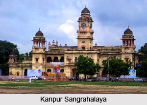
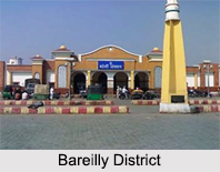
Bareilly is the divisional headquarters of Bareilly district and one of the fastest-growing cities in Uttar Pradesh. Known as a medical hub and an important industrial center, Bareilly is also among the top urban growth corridors in the state. The district was established before India’s independence and has since evolved into a major city known for its trade, healthcare, and educational institutions.
Budaun, another historically significant district, also dates back to the pre-independence era. Steeped in political and cultural heritage, Budaun is considered one of the oldest continuously inhabited cities in India. It served as the capital of India during the reign of Sultan Iltutmish, and its name is believed to have originated from Ahir prince Budh, who once ruled the region. The district is dotted with monuments that reflect its royal past.
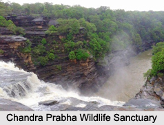
Pilibhit is a district renowned for its rich biodiversity and environmental significance. Also formed before independence, Pilibhit is home to the Pilibhit Tiger Reserve, officially designated in September 2008. This reserve, with its lush forests and diverse wildlife, has become a vital part of India's efforts to protect endangered species like the Bengal tiger.
The fourth district, Shahjahanpur, was established in 1813
by the British administration. Previously a part of Bareilly district,
Shahjahanpur emerged as a separate administrative unit with its own identity
and significance. The main town, Shahjahanpur city, serves as the district
headquarters. The district is divided into five tehsils- Powayan, Kalan,
Tilhar, Jalalabad, and Sadar. Shahjahanpur also played a prominent role in
India's independence movement and continues to be remembered for its
contributions to national history.
Major Cities of West Uttar Pradesh
Western Uttar Pradesh has a wide array of cities that play a crucial role in shaping the state's economic, cultural, and administrative landscape. Known for its blend of industry, agriculture, education, and historical heritage, this part of the state is both vibrant and diverse.
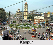
Among the major urban centers, cities like Meerut, Ghaziabad, Noida, Agra, Aligarh, Moradabad, Bareilly, Saharanpur, and Hapur stand out for their substantial contributions to trade, commerce, industry, and education. These cities are not just economic powerhouses but also serve as key cultural and educational hubs.
Agra, globally renowned for the majestic Taj Mahal, is a hub
of international tourism and represents the historical richness of the region.
Meerut, on the other hand, is a significant industrial, trade, and transport
center with historical significance dating back to the Revolt of 1857. Mathura,
deeply rooted in Hindu mythology as the birthplace of Lord Krishna, also holds
industrial importance with a major oil refinery adding to its economic value.

Ghaziabad serves as a major industrial city and is an integral part of the National Capital Region (NCR), benefiting from proximity to Delhi. Similarly, Noida and Greater Noida have emerged as modern urban centers with rapid infrastructure growth, IT hubs, and educational institutions. Cities like Moradabad, known for its brass handicrafts, and Saharanpur, famous for wood carving, highlight the region's artisanal expertise.
A number of other important cities
further enrich the region’s urban fabric. These include Baghpat, Budaun, Mathura,
Sambhal, Amroha, Bulandshahr, Hathras, Kasganj, Muzaffarnagar, Rampur, Shahjahanpur,
Etah, Firozabad, Mainpuri, Shamli, Bijnor, Najibabad, Farrukhabad, Etawah, and Auraiya—each playing a
unique role in the administrative and economic framework of the state.
Geography in Districts of West Uttar Pradesh
The geographical landscape of in the districts of Western Uttar Pradesh is marked by a rich blend of natural features, shaped by its location, soil composition, and climatic influences. Nestled in the northwestern part of the state, this region shares borders with six Indian states—Uttarakhand, Himachal Pradesh, Haryana, Delhi, Rajasthan, and Madhya Pradesh and also touches an international boundary with Nepal through the Pilibhit district.
Unlike the plains of eastern Uttar Pradesh, the western
districts exhibit distinct geographical characteristics. The soil composition
here is predominantly light-textured loam, with patches of sandy soil found in
various areas. A unique feature of the region is the loess soil which is fine,
wind-deposited sediments that drift eastward from the Thar Desert in Rajasthan,
subtly altering the terrain over time.
Climate in Districts of West Uttar Pradesh
The climate across the districts of Western Uttar Pradesh follows a tropical monsoon pattern, though local variations occur due to differences in altitude and terrain. The region experiences wide-ranging temperatures throughout the year, from chilly winters to scorching summers.
Three Distinct Seasons Define the Region
Summer (March to Mid-June):
Summers in West Uttar Pradesh are long, hot, and dry.
Daytime temperatures often soar between 43°C to 45°C, with occasional spikes
reaching 47°C to 48°C in some interior districts. The relative humidity remains
low, averaging around 20%, and strong dust-laden winds are a common feature of
this season. The oppressive heat makes summer a challenging period, especially
for outdoor labor and agriculture.
Monsoon (June to September):
This is the most crucial season for the region’s
agriculture. The southwest monsoon brings nearly 85–90% of the region’s average
annual rainfall of 990 mm. While the rains provide much-needed relief from the
summer heat—bringing temperatures down to around 40°C on rainy days, they also
bring risks. Flooding is common, particularly in low-lying districts like those
in the Rohilkhand region, often leading to damage of crops, infrastructure, and
livelihoods. Still, the monsoon remains the backbone of farming in this region.
Winter (October to February):
Winters are cool and pleasant, with average minimum
temperatures dropping to 3°C to 4°C in January. Skies are generally clear,
although fog is common during early mornings, especially in districts like
Meerut, Saharanpur, and Bareilly. The cold season is important for Rabi crops,
particularly wheat, which thrives in the mild and stable winter climate.
Rainfall Pattern and Challenges:
Climatic patterns in this region are shaped by two major
weather systems- the Indian Monsoon and Western Disturbances. The Indian
Monsoon arrives in late summer, sweeping up moisture-laden winds from the
Indian Ocean and delivering vital rainfall that supports the Kharif (autumn)
crops. This seasonal rain is essential for crops like rice, maize, and pulses,
forming the backbone of the region’s agricultural cycle.
Rainfall across Western Uttar Pradesh varies between 600 mm to 1,000 mm (24 to 39 inches) annually. However, most of this precipitation is concentrated during the monsoon months. This heavy concentration within just four months often leads to seasonal imbalances. While floods pose a recurrent threat during the rainy season, occasional monsoon failures bring the opposite challenge such as drought, leading to crop failures and water scarcity.
In contrast, the Western Disturbances, a winter weather
phenomenon bring rainfall from the Mediterranean Sea, Caspian Sea, and Atlantic
Ocean. These disturbances are extratropical in nature and play a crucial role
during the colder months. They are particularly important for the success of
the Rabi (spring) harvest, especially wheat, which is the region’s staple crop.
Demography in Districts of West Uttar Pradesh
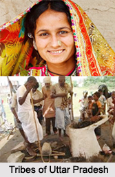
Demography in the districts of western Uttar Pradesh reflects its rich cultural and historical depth, shaped over centuries by the migration, settlement, and intermingling of diverse communities. Uttar Pradesh, the most populated state in India, has higher concentration of its population in the western districts. This populous region is home to an intricate blend of castes, tribes, and religious groups.
Western Uttar Pradesh is inhabited by various communities including Gurjars, Jats, Rajputs, Tyagis, Kayasthas, Brahmins, Ahirs (Yadavs), Kachhis, Kahars (Kashyaps), Gadarias, Banias, Kumhars, Lodhas, Valmikis, Nais, Jatavs, Kurmis, and Khatiks. One of the distinct ethnic groups in the region is the Rohilla Pashtuns, who trace their roots to Afghan immigrants and have a significant presence in the Rohilkhand region, which is named after them.
Although Yadavs form a dominant caste group in other parts of Uttar Pradesh, their presence in the western districts is relatively limited. On the other hand, Sikhs, who migrated from West Punjab during the Partition in 1947, also settled in large numbers across parts of Western UP, contributing to its agricultural and entrepreneurial base.
During the 1980s and 1990s, Western Uttar Pradesh witnessed the rise of a so-called “sugarcane mafia”, with powerful influence stemming from agrarian castes such as Jats, Gurjars, Rajputs, and Tyagis. This era was marked by growing competition over control of sugarcane mills and cooperative societies, reflecting the political clout and economic aspirations of these communities.
According to the 2011 Census, the total population of
Western Uttar Pradesh stood at 71.2 million. Of this, approximately 72.29%
identified as Hindu, while 26.21% were Muslim. The region’s demographic makeup,
however, varies significantly between subregions.
Languages Spoken in Districts of West Uttar Pradesh
Districts of Western Uttar Pradesh have a diverse linguistic landscape as a result of centuries of cultural interaction, migration, and historical influence. The region primarily speaks Hindi, along with its prominent regional dialects like Khadiboli and Braj. These languages form the linguistic backbone of this part of the state.

In the northern belt of Western Uttar Pradesh, the dominant spoken dialect is Khadiboli, an early form of modern Hindi that has only minor differences from standard Hindi spoken today. Khadiboli is widely regarded as the linguistic foundation of both modern Hindi and Urdu, having evolved during the medieval period through a blend of local Prakrit, Apabhramsha, and Persian influences were introduced during the Delhi Sultanate and Mughal eras.
Khadiboli is predominantly spoken in districts of Muzaffarnagar, Saharanpur, Shamli, Baghpat, Ghaziabad, Meerut, Hapur, Amroha, Sambhal, Bijnor, Bareilly, Gautam Buddha Nagar, Bulandshahr, and Moradabad. These areas, located closer to Delhi and the upper Gangetic plain, were historically part of important administrative and cultural centers, allowing Persian vocabulary to gradually blend into the local Khadiboli speech.
Moving southward, the dominant dialect transitions to Braj Bhasha, an older and culturally rich form of Hindi. Braj has deep literary and devotional significance, especially in the context of Lord Krishna and the Bhakti movement, with poets like Surdas using Braj as their primary medium of expression. Braj-speaking districts include Mathura, Hathras, Agra, Aligarh, Etah, Firozabad, Budaun,
Mainpuri, Bareilly, Sambhal, Bulandshahr, and Gautam Buddha
Nagar. Although Braj is not as commonly used in official settings today, it
remains widely spoken in rural areas and continues to influence local
literature, folk traditions, and oral storytelling.
Transportation in Districts of West Uttar Pradesh
The transport infrastructure of Western Uttar Pradesh is quite well-developed and strategically significant. With its proximity to the National Capital Region (NCR) and connections to major industrial and agricultural centers, the region boasts an extensive and growing network of national highways and expressways that support trade, mobility, and regional development.
A large number of national highways (NH) crisscross Western Uttar Pradesh, linking its cities with each other and with neighboring states such as Delhi, Haryana, Uttarakhand, Rajasthan, and Madhya Pradesh. Some of the key highways include:
NH 2 (now NH 19): An arterial route connecting Agra to Delhi and further towards Kolkata.
NH 3: Linking Agra to Gwalior and central India.
NH 9: A major route passing through Ghaziabad, Hapur, and Moradabad.
NH 58: Connecting Delhi with Meerut and onward to Rishikesh.
NH 73, NH 74, NH 87: Connecting districts in the Saharanpur and Bareilly belts to Uttarakhand and the Himalayan foothills.
NH 91, NH 509, NH 530B: Supporting intra-state connectivity between Aligarh, Budaun, Etah, and Mainpuri.
NH 119, NH 235, NH 709A, NH 709B, NH 709AD: Facilitating efficient transport through less urbanized districts like Shamli, Bijnor, and Muzaffarnagar.
These highways form the backbone of road transport, ensuring quick movement of agricultural goods, industrial products, and people across districts and beyond state borders.
List of High-Speed Corridors of Progress
Western Uttar Pradesh is also home to some of India’s most advanced expressways, designed for high-speed, long-distance travel.
Noida–Greater Noida Expressway: A vital route
connecting tech and business hubs in Gautam Buddha Nagar.
Yamuna Expressway: A six-lane expressway that links
Greater Noida to Agra, significantly reducing travel time and enhancing tourism
and logistics.
Agra–Lucknow Expressway: Facilitates rapid east-west
movement, connecting Agra with central Uttar Pradesh.
Delhi–Meerut Expressway: One of the most modern
highways in India, providing smooth transit from the NCR to Western UP.
Eastern Peripheral Expressway: A ring road around
Delhi, offering congestion-free connectivity for cities like Ghaziabad,
Baghpat, and Noida.
Ganga Expressway (under construction): Set to be one
of India’s longest expressways, this corridor will connect districts such as
Meerut, Budaun, and Prayagraj, transforming regional connectivity.
Delhi–Dehradun Expressway (under development): Expected
to benefit the Saharanpur belt, boosting tourism and trade with Uttarakhand.