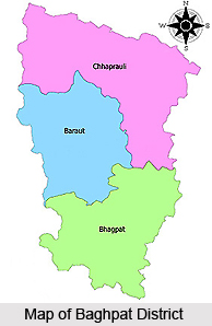
 Baghpat District is amongst the 71 districts of the Indian state of Uttar Pradesh. The headquarters of the state is the town of Baghpat. Baghpat district is scattered over an area of 1321 sq km. Baghpat district is further segmented into 3 tehsils, namely Baghpat, Khekra and Baraut. These are also the 3 major towns in Baghpat district. There are 2 blocks in Baghpat tehsil- Pilana and Baghpat. Baraut tehsil has 3 blocks, Baraut, Binauli and Chhaprauli. The tehsil Khekra has only the Khekra block. The Yamuna River streams to the west of the districts. Katha, Sisana and Mitli are the most popular villages in the district. The total population of the district of Baghpat is around 1,302,156.
Legends of Baghpat District
According legends, the region was initially named by the Pandavas, as Vyagprastha or the Land of Tigers as many centuries ago there were numerous tigers present in the area. Another legend states that it was actually called Vakyaprasth, meaning place of delivering speeches. During the Mughal period, the region was finally named Baghpat, which was derived from the earlier version.
Demography of Baghpat District
The population of Baghpat district is 1,302,156, as per the 2011 census. The population density of the district is 986 inhabitants per sq km. The gender ratio is 858 females for every 1000 males, where as the literacy rate is 73%. During 2001-2011, population growth rate has been around 12%.
Education of Baghpat District
There are many significant schools and colleges in the district that have adequately contributed to the development of the state. These include, DAV public School (CBSE), Shri Yamuna Inter College (UP board), St. Angle senior secondary School (CBSE),
Christu Jyoti Convent High School (ICSE), Digambar Jain College, Janta Vedic College etc.
Economy of Baghpat District
Baghpat is mainly agriculture and cultivation oriented district. Mustard, wheat, sugarcane and various types of other vegetables are grown in abundance. Creating and selling Gur or Jaggery is also one of the prime occupations of the inhabitants of Baghpat district. Baraut is popular for the Rim and Dhura and several industries based on agricultural implements. Manufacture of shoes and related products is also carried on through out the state.
Adminstration of Baghpat District
Baghpat, Chhaprauli and Baraut are the 3 Uttar Pradesh Vidhan Sabha constituencies in Baghpat district. These are included in the Baghpat Lok Sabha constituency.
Tourism of Baghpat District
Baghpat district, located on the banks of Yamuna River, comprises of masny popular tourist places such as Gufawala Mandir, Pura Mahadev, Yamuna Ghat, Bhole ki Chhal and the celebrated Jain temple at Badagaon.