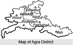
 Agra District is situated in western region of Uttar Pradesh. It is located between latitudes 27 degree 11 minutes north and 78 degree to 78 degree 2 minutes longitude east. Average altitude of Agra District is 169 meters above sea level. On the north it is bounded by Mathura District, on the south it is bounded by Dhaulpur District, on the east it is bounded by Firozabad District and on the west it is bounded by Bharatpur. Agra, the historical city, is the district headquarters. This city is situated on the bank of Yamuna River. In Agra maximum temperature in summer is around 45 degree Celsius and minimum temperature is near about 21.9 degree Celsius and in winter minimum temperature is about 4 degree Celsius. Best season for tourist is from October to March.
History of Agra District
The history of Agra District begins much earlier than the Taj; it finds mention in the epic Mahabharata when it was called Agrabana. Ptolemy, the famous second century AD geographer, marked it on his map of the world as Agra. Tradition and legend ascribe the present city of Raja Badal Singh (around 1475 AD) as his Badalgarh Fort stood on or near the site of the present Fort. It was the Mughals who finally nurtured Agra with the finest monuments architects could design.
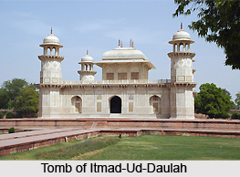 The Taj Mahal of Shah Jahan, Agra Fort of Akbar and Itmad-Ud-Daulah stand in mute testimony to the city`s grandeur over the ages.
Administration of Agra District
Agra district is divided into six Tehsils and 15 Blocks. Total number of Panchayats in the district is 114 while Gram Sabhas stands at 636. The total populated villages are around 904. Total number of police stations in the district is 41 out of which 16 in urban area and 25 in rural area.
Economy of Agra District
Primarily the economy of the Agra District is agriculture based while the economy base of Agra city is small scale industries, commerce and trade. Major crops grown in the district are Wheat, Paddy, Bajra, Mustard, Potato, etc. About 40 percent of the total economy of Agra depends on industries (either directly or indirectly). Over 7200 Small Scale Industrial Units are spread all over the district. Agra city is famous for the Leather Goods, Handicrafts, Zari Zardozi, Marvel and Stone carving and inlay work. Agra is also well known for sweets and snacks.
Tourism in Agra District
There are various places of interest in Agra District. Tourism in Agra District is popular for its historical sites. Taj Mahal, Agra Fort, Sikandara, Itmad-Ud-Daulah, Radha Swami Samadhi, Fatehpur Sikri, Taj Mahotsava and Soor Sarovar Bird Sanctuary are some of the popular attractions of Agra District. Tourism in this district also includes visits to several holy sites and temples.
Agra District has proper educational and healthcare facilities.


