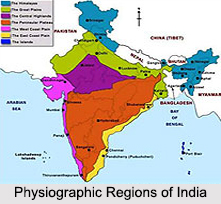
 Physiographic divisions of India include physical features of the country. India stretches from 8 degrees and 4 minutes north to 37 degrees and 6 minutes north latitudes. It also extends from 68 degrees and 7 minutes east to 97 degrees and 25 minutes east longitudes. The neighboring countries of India are Bhutan, Burma, China, Nepal and Pakistan. India shares some of its physical features with its neighboring countries. Arabian Sea in the west, Bay of Bengal in the east and Indian Ocean in the south, bound India. Expanse, height and location of India`s landforms such as the mountains, plateaus, hills and plains have played a major role in influencing the climate, distribution of population, land-use, means of transportation, etc of the country. There are six physiographic divisions of India. These divisions are noticeably different from one another in terms of surface configuration and are described below:
Indian Mountains
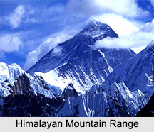
There are many mountain ranges in India. The most distinguished is the Himalayan Mountain Range or the Himalayas in the north, with Kanchenjunga Peak as its highest peak in India. This mountain peak measures 8586 meters. The Himalayas are young fold mountains with great magnitude of local relief, very steep slopes, highly uneven surface, little leveled land and young river valleys. The Himalayas form a highly rugged and continuous stretch of high mountains, which flank northern India for a considerable length and stretch between the Brahmaputra Gorge in the east and the Indus River in the west. They are relatively broad in the Indian state of Himachal Pradesh and Kashmir and highest in eastern Nepal. The Himalayas rest against Ladakh of Jammu and Kashmir and the Tibetan Plateau in the form of an arc-like rim.
 Kashmir Himalayas has an average height of around 3000 m. Pir Panjal Range and Kashmir Valley belong to the Kashmir Himalayas section. Punjab Himalayas is characterized by rugged northern slopes and forested southern slope. High peaks are rare in the section of Punjab Himalayas. Lakes like Manasarovara Lake and Rakshas Tal, passes like Zojila Pass, Rohtang Pass and Bara Lacha Pass and valleys like Kangra Valley and Lahul and Spiti Valley are part of Punjab Himalayas. Kumaon Himalayas ranges from Sutlej River to Kali River. Pilgrimage centers like Badrinath and Gangotri Region of India are part of Kumaon Himalayas. Assam Himalayas extends from Teesta River to Brahmaputra River. Central Himalayas extends from Kali River to Teesta River. Lesser Himalayas rises north of the Siwalik Range. Being deeply cut by rivers, this belt of mountains is highly rugged. The Great Himalayas or Himadri is a long and continuous range of mountains. It is the highest range in the world with an average height of about 6100 meters above the sea level. Eastern Himalayas consists of hill ranges which pass through eastern Arunachal Pradesh and the states having border with Burma. Three important rivers of India namely, the Brahmaputra River, Sutlej River and Indus River have their sources near Manasarovara Lake, situated to the north of the Great Himalayas.
Other than the Himalayas, Indian Physiography also includes other mountain ranges like the Vindhya Mountain Range that traverses nearly the whole width of peninsular India and the Sahyadris Mountain Range along the Western Ghats, with an average height of about 1200 meters. The Siwalik Range has low parallel ridges, mainly made up of boulder and clay.
 Plains of Northern India
Plains of Northern India are surrounded by the Himalayas in the north and the Deccan Plateau in the south. These plains are flat and have been created by alluvial deposits brought down by three rivers namely, the Indus, Ganga and Brahmaputra. They stretch from east to west for about 2,400 km and for about 200 to 400 km from north to south. This region of India is spread over an area of about 5, 80,000 square kilometers. Plains of northern India have been divided into the Punjab Plain, the Ganga Plain and the Brahmaputra Valley.
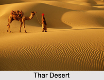
Great Indian Desert
Great Indian Desert, one of the physiographic divisions of India, refers to the Thar Desert in the north western part of India. It is considered to be the 9th largest subtropical desert and the 17th largest desert in the world. It is spread over an area of about 320,000 square kilometers, thus covering approximately 10 percent of the total geographical area of India. The rainfall in the region ranges from 100 to 500 mm, annually. Maximum portion of the desert comprises of shifting sand dunes which receive sediments from the alluvial plains and the coast.
Indian Peninsular Plateau
The peninsular India is an old shield block having relict mountains and old river valleys. Peninsular plateau stretches till Jaisalmer in the west. Indian Peninsular Plateau is the oldest part of the country known as the Indian Plate. The peninsular plateau can be divided into three physiographical groups namely, the Deccan Plateau (including the Western Ghats and Eastern Ghats), Central Highlands (including the Malwa Plateau and Chhota Nagpur Plateau) and Northeastern Plateau. The Plateau of Peninsular India is fringed with narrow coastal lowlands. Raised beaches and wave cut platforms above the high water mark signify that these lowlands are essentially emerged floors of the seas, adjoining the land. The east coastal lowland is broad in Tamil Nadu.
Indian Coastal Plains
Coastal Plains are located to the east and west of the peninsular plateau of India. Coastal Plains have been divided into the western coastal plain and the eastern coastal plain. The width of the western coastal plain ranges from 10 to 15 km, whereas the width of the eastern coastal plain ranges from 50 to 60 km. With the exception of Gujarat, the western coast is narrower than the eastern coast.
Indian Islands
There are about 247 Indian Islands, out of which 204 islands lie in the Bay of Bengal and the remaining lie in the Arabian Sea and the Gulf of Mannar. The main islands of India are the Lakshawadeep in the Arabian Sea and the Andaman and Nicobar Islands in the Bay of Bengal. Lakshawadeep is a group of islands, which is surrounded by fringing reefs and has a total area of about 32 square kilometers. Andaman and Nicobar Islands is also a group of islands, known to be formed by the submergence of Arakan Yoma Range. The Barren and Narcondam islands are situated north of Port Blair and are volcanic in nature. The Pamban Island is situated between India and Sri Lank and has rocky surface. It is an extension of the peninsular surface in Ramnad district of Tamil Nadu.


