
Introduction
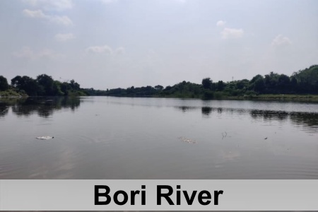
Bori River is a significant left-bank tributary of the Bhima River, which is the principal tributary of the Krishna River system. Flowing primarily through Maharashtra, the river’s lower course extends briefly into Karnataka. Its hydrological pattern is strongly influenced by seasonal changes, with water discharge increasing substantially during the southwest monsoon months from June to September and declining considerably during the dry season. This pronounced seasonal variation has a direct impact on agricultural activities and water availability across the river’s catchment area.
Despite
these fluctuations, the Bori River remains an essential resource for the local
agrarian economy. It provides critical irrigation support
to the drought-prone districts of Dharashiv and Solapur, helping farmers
sustain agricultural production in challenging climatic conditions. The river’s
waters contribute to the cultivation of key crops such as sugarcane,
pulses,
and cereals.
Course of Bori River
Bori River originates in the Balaghat Range near the hills of Dharur, close to Tuljapur, at an elevation of approximately 600 to 700 meters above sea level. Its source is located near Bori village in Dharashiv district, where a network of headwater streams emerges from seasonal springs replenished by monsoon rainfall in the foothills of the Western Ghats. From its origin, the river follows a predominantly southward course across the Deccan Plateau, flowing through the Osmanabad region and continuing toward Akkalkot.
As it traverses the landscape, the Bori River flows along the base of the historic Naldurg Fort. In this stretch, the river briefly widens, forming natural moat-like features that have historically enhanced the fort’s defensive position. Continuing its journey across the plateau, the river is joined by several seasonal streams and receives runoff from surrounding agricultural lands, increasing its flow during the monsoon season.
After crossing into Karnataka, the Bori River eventually merges with the Bhima River from the left bank near the town of Afzalpur, situated close to the Maharashtra–Karnataka border. Through this confluence, the river contributes to the Bhima’s waters as the larger river continues its south-eastward course toward the Krishna River basin.
Tributaries of Bori River
Bori River is sustained by a network of minor tributaries and seasonal streams that originate primarily in the hilly terrain of its upper catchment. Among these, the Harna River is recognized as its principal tributary. The Harna joins the Bori near the Kurnur Dam site in the Akkalkot region of Solapur district, creating an important confluence that contributes to local water storage and supports irrigation activities in the surrounding agricultural areas.
Beyond the Harna River, the Bori receives additional inflows from numerous unnamed seasonal nalas that descend from the slopes of the Balaghat Range, the river’s source region. These ephemeral streams become active mainly during the monsoon season, carrying runoff from the uplands and significantly increasing the river’s discharge. Together, these seasonal waterways and smaller sub-tributaries form an extensive feeder network that reflects the varied topography of the basin.
The drainage system of the Bori River exhibits a predominantly dendritic pattern, a characteristic feature of the broader Bhima River basin. In this arrangement, tributaries branch out in a tree-like fashion across the relatively uniform basaltic terrain of the Deccan Plateau. In the upper reaches near the Balaghat Range, tributary channels are generally short and steep, enabling rapid runoff during periods of rainfall. As the river progresses downstream across the plateau, the drainage network becomes more extensively developed, displaying the classic dendritic structure shaped by the region’s geology and landscape.
This
drainage pattern plays an important role in influencing the river’s sediment
transport and channel morphology. Runoff from the upper catchment carries
sediments into the main channel, while the interconnected network of
tributaries contributes to the overall hydrological dynamics of the basin.
Bori River Basin
Bori River Basin is located predominantly within Maharashtra, extending marginally into northern Karnataka near its confluence with the Bhima River. Situated on the Deccan Plateau, the basin forms an important component of the larger Krishna River system and contributes to the watershed divide between the Krishna and Godavari river basins. Its varied landscape reflects the region’s diverse geographical and ecological characteristics.
Agriculture dominates land use throughout much of the Bori River basin, particularly in the middle and lower reaches, where fertile valleys support extensive cultivation. Farmers in these areas grow crops such as sugarcane and cotton, which play a significant role in the local economy. In contrast, the upper reaches of the basin are characterized by the forested hills of the Balaghat Range. As the river flows downstream, the terrain gradually transitions into arid plateaus marked by semi-arid scrub vegetation and open grasslands, features that are typical of the Deccan region.
The basin is largely underlain by medium to deep black cotton soils, commonly known as regur soils. These vertisols, formed from basaltic parent rock, are highly fertile and well-suited for rainfed agriculture. However, their tendency to swell when wet and crack upon drying makes them vulnerable to erosion during the monsoon season. This dynamic soil behaviour significantly influences agricultural practices and land management within the basin.
The Bori
River basin supports a predominantly rural population whose livelihoods are
closely linked to the river and its resources. Communities across the basin
depend on its waters for irrigation, domestic use, and livestock rearing,
making the river an essential component of the region’s agricultural
productivity and everyday life.
Biodiversity of Bori River
Bori River and its surrounding landscapes support a diverse range of flora and fauna characteristic of the Deccan Plateau. The riparian zones along the river are primarily covered by dry deciduous forests, where species such as teak and babul are commonly found. These forested stretches are interspersed with riverine grasses and other vegetation adapted to the region’s semi-arid climate. In the upper reaches of the basin, the vegetation transitions into monsoon deciduous forests, reflecting the influence of seasonal rainfall patterns on the local ecosystem.
The river and its associated reservoirs also sustain a rich aquatic community. Fish diversity is particularly notable, with many species belonging to the Cyprinidae family. Among the commonly recorded species is Labeo rohita, along with several other cyprinid fishes that share ecological similarities with mahseer. Altogether, surveys have documented 39 fish species representing 12 different families, forming an essential component of the river’s food web and contributing to the ecological balance of the aquatic environment.
Birdlife flourishes in the wetlands, reservoirs, and riverbanks associated with the Bori River. Studies conducted around the Bori Dam have recorded 18 species of piscivorous birds that depend on aquatic habitats for feeding. These include kingfishers such as Common Kingfisher and Pied Kingfisher, as well as herons including Grey Heron and egrets such as Little Egret. Storks, including Asian Openbill, are also frequently observed along the river’s wetlands. In addition to avian species, the surrounding habitats support mammals such as the Chinkara, which inhabits the scrublands and grasslands of the region.
The ecological significance of the Bori River basin is further enhanced by its proximity to Yedshi-Ramling Wildlife Sanctuary, where more than 100 bird species have been recorded. Together, the river, its reservoirs, and adjacent protected areas create a mosaic of habitats that support substantial biodiversity and contribute to the environmental richness of the Deccan Plateau.

Dams on Bori River
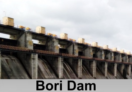
The Bori River is supported by several water control structures that have been developed primarily to enhance irrigation and water security in the drought-prone regions of Maharashtra. Among the most significant of these is the Bori Medium Irrigation Project Dam, an earthfill dam constructed across the Bori River near Tamaswadi in the Parola region of Jalgaon district. The dam rises approximately 20 meters above its lowest foundation and extends for 3,365 meters in length. It has a volume content of about 0.05534 cubic kilometers and a gross storage capacity of approximately 0.009827 cubic miles, making it an important component of the region’s irrigation infrastructure.
Further downstream, the Kurnur Dam is located near Akkalkot town at the confluence of the Bori and Harna rivers. This earthfill structure stands 23.7 meters above its lowest foundation and stretches 1,206 meters in length. Constructed in 1968, the dam serves as a vital water resource for the surrounding communities. It provides a dependable source of water for residents of Akkalkot Taluka and plays a crucial role in supporting agricultural activities across nearby villages. For the people of Kurnur village in particular, the dam fulfills essential domestic and livelihood needs, supplying water that sustains both daily life and farming operations.
In addition
to these major reservoirs, the Bori River basin contains numerous minor check
dams that have been established for soil conservation and groundwater recharge.
These structures are especially common in the upper reaches of the basin, where
they help manage seasonal runoff and improve water retention. Typically
constructed from earth or masonry and ranging from five to ten meters in
height, these smaller dams are designed to reduce soil erosion, stabilize local
hydrological conditions, and promote groundwater replenishment.
Tourist Spots Along the Banks of Bori River
Several historically and culturally significant places are situated along or near the course of the Bori River, including the town of Tuljapur and the historic city of Naldurg. Tuljapur is renowned as one of Maharashtra’s most important pilgrimage centers. The town is home to the Tulja Bhavani Temple, a 12th-century Hindu temple dedicated to Goddess Bhavani. Every year, the temple attracts thousands of devotees during the Navaratri festival, when the annual Tulja Bhavani fair is held. Over the centuries, the shrine has gained particular historical prominence through its close association with the Bhonsle dynasty, the royal family to which Chhatrapati Shivaji belonged.
Further
downstream lies the historic town of Naldurg, which is best known for the
imposing Naldurg Fort. Constructed during the Bahamani and Adil Shahi
periods, the fort is regarded as one of the finest examples of medieval
military architecture in the region. Its strategic location near the Bori River
enhanced its defensive capabilities, with the river contributing to the natural
protection of the fortifications. Today, Naldurg remains an important
historical landmark, celebrated for its impressive architecture, rich cultural
legacy, and enduring significance in the history of the Deccan.









