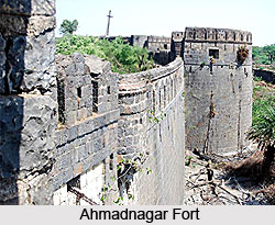
 Ahmadnagar District is the largest district in the state of Maharashtra, covering around 5.66 percent of the total area of the state. The historical heritage of the district is rather rich. The name of the district, Ahmadnagar, has come from the name of the founder of the town Ahmadnagar by Ahmed Shah Nizam. There are many places of historical importance, including the Ahmadnagar fort where many of the national heroes of the Indian freedom struggle were detained during Indian freedom movement. Pandit Jawaharlal Nehru wrote his famous book "Discovery of India" in Ahmadnagar Fort. Today, Ahmadnagar is the most advanced district having the maximum number of sugar factories, and aims to spread the message "rural prosperity through cooperation". The first cooperative sugar factory in Asia was established at Pravara Nagar. Excellent models of water conservation work can be seen at Ralegan-Siddhi and Hivare Bazar which are also called ideal villages.
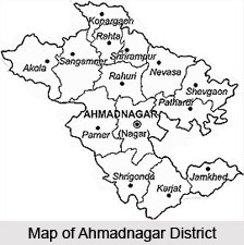
 Location of Ahmadnagar district
The district of Ahmadnagar is situated in the state of Maharashtra. It lies located in the central part of the state. Ahmadnagar lies between the north latitudes of 18.2 degrees to 19.9 degrees and between the east longitudes of 73.9 degrees to 75.5 degrees. It is bounded on the north by the Nashik district and Aurangabad district, on the east by the Beed district and Osmanabad district, on the south by the Solapur district and the Pune district and on the west by the districts of Thane and Pune.
History of Ahmadnagar District
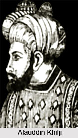
History of Ahmadnagar district can be traced as far back as 240 BC, when the vicinity was a part of the empire of Ashoka, emperor of the Mauryan Empire in India. Though not of much significance, the district did contain some important by-passes. A number of dynasties followed the Mauryas. The Andhrabrityas ruled here from B.C. 90 to A.D. 300, the Rashtrakuta Dynasty ruled over Ahmadnagar till about 400 A.D., the early Chalukya and Western Chalukya dynasty till 670 A.D. They were followed by the Rashtrakuta kings (670 to 973 A.D), western Chalukyas (973 to 1190 A.D) and the Yadavas of Devagiri (1170 to 1310). Ahmadnagar was the capital of the Yadavas, and the most noted minister of the time was Hemadri. His name deserves mention for his accomplishments, which include the Modi script and the system of constructing buildings without the help of lime or mortar. Twenty six such temples scattered over the whole district bear a testimony to this remarkable style. The Yadava dynasty was finally defeated due to its military unprepared ness at the hands of Ala-ud-din Khilji, the commander-in-chief of the King of Delhi, Jallal-ud-din Khilji at Devagiri in 1294.
This was the first ever invasion of the Muslim kings in the South across the Vindhya mountain range. This victory at the very first invasion gave a fillip to the Muslim ambition of establishing a Muslim stronghold in the Deccan. Maharashtra then began to be ruled by governors appointed from Delhi and stationed at Devagiri. An Afgan soldier Allaudin Hasan Gangu was successful in overthrowing the Delhi emperors and establishing an independent sovereign kingdom named after his Brahmin preceptor Gangu Brahmin at Gulbarga in 1347. He set up the Bahamani dynasty and the kingdom is known as the Bahamani or Brahmin kingdom. This kingdom lasted for 150 years and was ruled by 13 kings after Hasan Gangu Bahamani. Subsequently, the Bahamani kingdom was divided into five independent kingdoms, and Ahmadnagar was one of them. It now came under the sway of the Nizam Shahi dynasty of Ahmadnagar. A succession of rulers followed forth. This included Ahmed Nizam, Burhan Nizam Shah, Husain Nizam Shah who built the Ahmadnagar fort, Murtaza Nizam Shah, Miran Hussain Nizam Shah and others. The Nizam Shahi dynasty ultimately met its ruins at the hands of the mighty Mughal dynasty.
Shah Jahan appointed Aurangzeb as the viceroy in 1636 and again in 1650. Chatrapati Shivaji personally invaded Ahmadnagar in 1657 and in 1665. At other times Shivaji`s minister and generals attacked Ahmadnagar intermittently. Aurangzeb tried to put an end to the independent kingdom of the Marathas but he never succeeded in this and at last died in Ahmadnagar on 21st of February 1707. Shortly after this the fall of the Mughal power in the Deccan was completed by the revolt of Chin Killich Khan (Nizam-ul-Mulk), the governor of Malwa. Ahmadnagar was one of the parts of the Deccan which became subject to the Nizam and remained in his hands till his death in 1748.
The Rule of the Marathas (1759 to 1817)
After the death of Nizam-ul-Mulk a quarrel issued between his sons, Salabat Jung and Ghazi-ud-din. In this political mess the Nizam`s commandant Kavi Jung betrayed the fort of Ahmadnagar to the Peshwa, the minister of the Marathas. War followed between the Nizam and the Peshwas and the Nizam was defeated in 1760 at Udgir. Besides other concessions the Nizam confirmed the grant of Ahmadnagar and Dualatbad and also gave up the greater part of the province of Ahmadnagar. The Nizam was again defeated by the Marathas in 1795 at Kharda. Following the Battle of Kharda, Ahmadnagar fell into the hands of the Marathas.
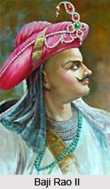
After the death of Sawai Madhav Rao in 1795, quarrels arose among the Maratha noblemen. In 1797 Daulatrao Sindia took the fort of Ahmadnagar from Baji Rao II, as the price of helping him to raise him to the post of Peshwa. The famous statesman Nana Fadnavis was imprisoned in Ahmadnagar fort in 1797 by Sindia. At last he was released in 1798 but sorely discouraged, Nana Fadnavis died in 1800.
Bajirao Peshwa was continuously harassed by Yashwant Rao Holkar and Daulatrao Sindia. So he concluded a treaty with the British for the safety of his ministership, on 31st December 1802 with the Treaty of Bassein. Now the noblemen had to fight with the British might. Lord Wellesley attacked Ahmadnagar city and captured it. Then he laid siege to Ahmadnagar fort on 9th of August 1803 and captured it on the 12th of August 1803. General Wellesley then returned the fort of the Peshwa soon i.e. in 1803. The Holkars also came to terms with the British. There was widespread disorder in the area due to famine and hundreds were looted, murdered and massacred by the Pindaris. There was a rebellion against the British rule by common people headed by Trimbakji Dengale of Sangamner. The British troops soon brought the circumstances under control with the help of their disciplined soldiers. At last a treaty was concluded with Bajirao Peshwa at Poona by virtue of which the Ahmadnagar Fort was handed over to the English.
British Rule and the freedom struggle (1817 to 1947)
When the British Government took possession of Ahmadnagar much of it was almost ruined. Many former rich areas were depopulated because of famine and continuous fighting between the British soldiers and the freedom fighters. They continued to rise in arms taking resort to villages and the hills and mountains- mostly Parner, Jamgao and Akola areas. The Kolies and the Bhils harassed the British troops intermittently.
During the great freedom Sepoy Mutiny , 1857, Ahmadnagar was a scene of considerable disturbance. The active freedom fighters were about 7000 Bhils under the leadership of Bhagoji Naik. They were active in the hilly tracks and especially in the Parner, Jamgao, Rahuri, Kopargaon and Nasik areas. But at last all these attempts to rise against the British failed and slavery came to stay. By about 1880 it was almost quiet everywhere.
During the nationwide freedom struggle, many of the famous leaders, except Mahatma Gandhi, were kept confined in the Ahmadnagar fort. Jawaharlal Nehru wrote his famous book Discovery of India while he was imprisoned in the Ahmadnagar Fort.
The famous leaders of Ahmadnagar were underground for many days. The veteran leader of Ahmadnagar district, Senapti Pandurang Mahadeo Bapat, was the most fearless and was one of the greatest disciples of Mahatma Gandhi. He carried on the Mulshi Satyagraha bravely and was arrested in 1937. He was kept behind bars till India achieved her independence. Senapti Bapat never cared for anything and was ever prepared to lay down his life in the freedom struggle. India attained her freedom on the 15th of August 1947 and all the brave leaders were released from imprisonment. The flag salutation ceremony took place on the ramparts of the Ahmadnagar Fort at 8 a.m on 15th August 1947 at the hands of Acharya Narendra Dev who was interned in the Fort for a long time during the struggle for freedom.
 Geography of Ahmednagar District
The whole district forms part of the great trap region of the Deccan. Throughout Ahmadnagar, the trap rock is distinctly stratified and, as in the rest of the Deccan, the alternative belts of basalt and amygdaloid preserve a striking parallelism to each other .There are various land forms in Ahmadnagar district. There are hilly off-shoots of the Sahyadris in the western part of he district. In the northern part of the district, plains are found along the banks of the Godavari River and Pravara River and in the southern part, along the rivers Bhima, Sina and Ghod River.
The different land forms in a region constitute its physical setup. If we consider the physical setup of Ahmadnagar district we see that there are three physical divisions
1. Western Hilly Region
2. Central Plateau Region
3. The region of northern and southern plains
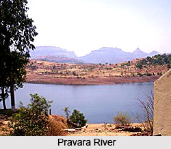
The important rivers flowing through the district are Paravara River, Mula River, Sina River and Dhora River. Pravara is a tributary of the Godavari River. Waters of the river Pravara fall from a great height creating the Randha Falls.
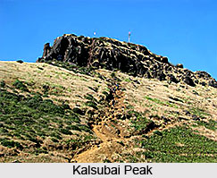
Western Hilly Region: Akole taluka and of Sangamner taluka are included in this region. The hill ranges of Adula, Baleshwar and Harishchandragad lie in this region and various high peaks are found in the same region. Kalsubai of height of 5427 feet, the highest peak in the Sahyadris, lies in this Region.
Central Plateau Region: Parner and Ahmednagar talukas and parts of Sangamner, Shrigonde and Karjat talukas are included in this region.
Region of Northern and Southern Plains: This region includes northern Kopargaon, Rahata, Shrirampur, Rahuri, Newasa, Shevgaon and Pathardi talukas. This is the region of the Godavari and the Pravara river basins. Parts of the southern talukas of Shrigonda, Karjat, Jamkhed are also included in this physical division. This region covers basins of the Ghod, Bhima and the Sina rivers.
The district is drained by two chief rivers: Godavari River and the Bhima a tributary of Krishna River. The Water-shed line is the great spur of the Sahyadris which branches off at Harichandragad and stretches completely across the district from west to east. The important rivers flowing through the district are Paravara, Mula, Sina and Dhora. Pravara is tributary of the river Godavari. Water of the river Pravara falls from a great height, creating the Randha Falls.
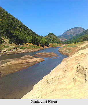
The Godavari, which drains by far the larger part of the district, including the tahsils of Kopargaon, Sangamner, Akole, Rahuri, Newasa, Shevgaon the northern half of Parner and parts of Nagar and Jamkhed, rises near Trimbak in Nashik on the eastern slope of the Sahyadris. After passing the Nashik city it receives the Banganga and the Kadva from the north and Darna from the south and is already a considerable stream, when, after course of about sixty miles, it enters north-west corner of the Kopargaon tahsil. It then flows south-east through rich alluvial plain past Kopargaon to the town of Puntamba, which is situated on the Nizam`s frontier ,where it receives from the south the combined water of Kat and Khara rivers. From Puntamba to a point beyond Paithan, a distance of sixty miles, the Godavari forms almost continuously the boundary between Ahmednagar and the Nizam`s dominions. At the village to Toka it receives on its right bank the combined waters of the Pravara and the Mula. A few miles below, the Shiva and Ganda join it from the left and the Dhora from the right. Two miles east of Mungi the river enters the Nizam`s dominions, and hence, flowing across the peninsula, it empties itself into the Bay of Bengal after the total course of 900 miles.
The Pravara rises on the eastern slopes of the Sahayadris between Kulang and Ratangad. After the sinuous course of twelve miles in an easterly direction, near the village Ranad, it falls into rocky chasm 200 feet deep and then winds for eight miles through a deep narrow glen which opens wider Valley East of and below the central plateau on which the town of Rajur stands. Total Length of Pravara is 120 miles. The Bhandardara Dam is constructed across the river at Bhandardara, near by are the Randha falls.
The Adhula rises in north of Akole on the Slopes of Patta and Mahakali. It flows for fifteen miles in an easterly direction between two ranges of hills which encloses the Samsherpur valley; then falling into the rocky chasm some 150 feet deep it winds between rugged and precipitous hill-sides for couple of miles, when, debounching in to the plain of Sangamner, it turns south and falls into the Pravara three miles west of the town of Sangamner.
The Mahalungi rises on the southern and eastern slopes of Patta and Aundha. After the course of three miles it passes east into the Sinnar subdivision of Nashik. It re-enters Ahmednagar after taking bend to south.
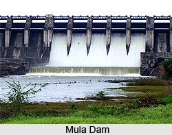
The Mula rises on the eastern slopes of the Sahaydris between Ratangad and Harichandragad. For first twenty miles it flows parallel to Pravara draining the southernmost or Kotul valley of Akole subdivision. Passing the town of Kotul it takes a bend to Baleshvar. It then crosses through Sangamner, Parner. The Mula Dam is constructed across the river at Baragaon Nandur.
The Dhora rises on the slopes of the hills east of the town of Ahmednagar. It flows in the north-east direction, draining Shevgaon and part of Newasa. The Bhima River drains the whole of the southern portion of the district, comprising the greater part of the Parner and Nagar subdivisions, the whole Shrigonda and Karjat, and nearly the whole of Jamkhed.
The Sina River has two chief sources, one near Jamgaon fourteen miles west of the town of Ahmednagar, near, Jeur ten miles to the north-east. The town of Ahmednagar is built on left bank of the river, which there takes south-easterly course. Leaving the district boundary it enters Solapur and ultimately merges with Bhima River.
The western hilly part of Ahmednagar district has forests. Indian Teak tree, babul, dhavada and Neem trees are found in these forests. Fruit trees like Mango, Tamarind, Amla and Bor are also found in the district.


