About Nashik District
 Amongst several districts that have flourished in the soils of Indian subcontinent the name of Nashik or Nasik district has drawn the attention of people from all over the world. Nashik district falls under the jurisdiction of Nashik District, Maharashtra state of the country. In the year1869 Nashik district was formed.
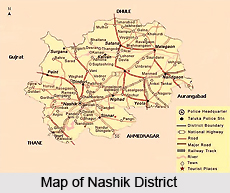
The geographical location of Nashik District is important. It covers a total area of 15,530 sq kms. Other Indian districts too form its boundaries. Instances also can be cited. On the northern part of Nashik District, Dhule district is situated; on the southeastern part lies Aurangabad district. On the south and southwestern part, districts like Ahmadnagar and Thane are situated. Valsad and Navsari districts lie on the west, and the Dangs district lie on the northwest part of Nashik District.
On the western part of Nashik District one also can find Western Ghats , also known as Sahyadri range . It extends from north to south.
Deccan Plateau of India encompasses quite a large area in the eastern part of Nashik District. It is open, lush and suitable for cultivation. The Godavari River has its origination in this Nashik District, which finally drains east towards the Bay of Bengal. To identify the true characteristics of Nashik District it becomes essential for a person to know the exact measurement of its population. As per a significant report of the year 2001, the total population of Nashik District has been enumerated to be 4,993,796. Out of it, urbanites form 38.80 %.
For better administration and controlling, the whole of the Nashik District has been divided into 15 talukas.
Again these talukas have been clubbed together under 4 sub-divisions. These are as follows:
Malegaon sub-division: Malegaon, Chandwad, Nandgaon
Nashik sub-division: Igatpuri, Dindori, Nashik, Nashik-College Road, Peint, Trimbakeshwar,
Kalwan sub-division: Kalwan, Deola, Satana, Surgana
Niphad sub-division: Sinnar, Yeola , Niphad.
 After a long drawn research eminent historians have brought forth important story that is related to the history of this Nashik District. At the time of eighteenth century this Nashik District was integrated to Maratha Confederacy, which was under the direct control of Peshwas of Maratha dynasty. Nashik District of Maharashtra is thronged with ancient hill forts, where traces of occurrence of Anglo Maratha wars are still being found. Afterwards in the year 1818 , this Nashik District is part of the British empire and Peshwas were overthrown. In the beginning it was at first divided into Kandesh and Ahmadnagar districts of Bombay Presidency.
For maintaining their living the residents of Nashik District have taken up various occupations. Agriculture is one of the main occupations. Crops like millet; wheat, pulse, oil-seeds, cotton and sugar cane are grown in abundance. . Also cultivation of vineyards, and gardening are in vogue in Nashik District. In some places people even practice professions like silk and cotton weaving. Flour mills, railway workshops, cantonments also are found in Nashik District.
For facilitating accessibility this Nashik District remains well connected with other place. As early as 1861 the chief `northeast line of the Great Indian Peninsula Railway` was finished. A chord line between Manmad, which is on the northeast line in Nashik district, and also Dhond, on the southeast line of Pune district took shape in the year 1878. .
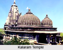
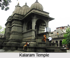
For pious devotees Nashik District provides lot many opportunities. Here , the revered Kumbh mela is feted once in every 12 years. Trimbakeshwar which is one of the twelve `Jyotirlingas` is a primary attraction . Others include Kalaram Temple, Vani or SaptaShrungi, Muktidham, Ozar ,Kalsubai, Someshwar, Mangi Tungi.
History of Nashik District
 History of Nashik district has been seen following a long journey, rooted in mythology as well as the district`s rich socio-cultural importance. Nashik has a rich historical past. No one knows when Nashik came into existence. It is said to have been present even in the Stone Age. According to mythology, Lord Rama, the King of Ayodhya, made Nashik his adobe during his 14 years in exile. At the same place Laskhmana, by the wish of Lord Rama, cut the nose of `Surpanakha` and thus this city situated here was named as `Nasik`. In Kritayuga, Nashik was `Trikantak`, `Janasthana` in Dwaparyuga and later in Kalyuga it became `Navashikh` or `Nashik`. Renowned poets like Valmiki, Kalidasa and Bhavabhooti have paid rich tributes here. Long ago, Brahmadeva had meditated in Padmasana here, so Nashik was also called Padma-Aasana for some time. It is also believed that, Lord Vishnu had defeated the three demons and thus the city also had the name Tri-Kantak (Tri-Three).
In 150 BC, Nashik was considered to be the country`s largest market place. From 1487 AD, this province came under the rulers of the Mughal dynasty. The Mughals were fascinated by the beauty of the city and renamed it as `Gulshanabad` meaning the city of gardens. Beautiful fresh flowers were sent to Aurangzeb from Gulshanabad i.e. Nashik. It was also the home of Emperor Akbar, and he has expounded in detail about Nashik in Ain-i-Akbari. But it was during the rule of Peshwa Raj in Maharashtra, when the place was finally renamed as Nashik. It was also known as the `Land of the brave` during the regime of Chatrapati Shivaji Maharaj. During the period of Peshwa rule, Raghobadada and his wife Anandibai settled down at `Anandwalli` in Nashik. There are some remains of Anandibai`s fort. There is also a temple called `Navasha Ganapati` built by Anandibai. It was during the British rule in April 1818, when Nashik once again regained its importance. The British fell in love with the beauty of the city and developed it in various fields. The Golf course, developed by the British, was one of the largest in Asia.
In 1869 Nashik was made a full-fledged district with its present talukas. With the return of peace Nashik flourished into prosperity. Reasons, political, religious, as well as commercial led to its rapid development. With the construction of the railway, going from Mumbai to north-east, religious minded devotees came to be attracted to the town in ever increasing numbers where they made their purchases of various artistic and useful articles. This made Nashik a great trade centre where artisans skilled in manufacturing utensils and smiths excelling in workmanship in silver and gold crowded to ply their trade.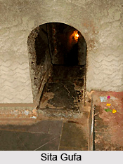
Already Nashik was a highly flourishing town even under later Maratha rule and, it was some time during this period when the sahukar families like Barves, Vaishampayans and Gadres of the locality started their financial activity. Under Maratha rule, they advanced sums to finance military campaigns of feudal Sardars, and in their later times their Pedhi`s gradually began to finance the flourishing trade in metalware and fabrics as well as grapes and onions. By the middle of the 19th century, British rule was firmly established and the public life of Nashik began pulsating with activities suited to the times. In 1840 `Native Library Nashik` was established; in 1861, an Anglo-vernacular school was started and in 1864, the town came to have a municipality of its own. Nashik played a prominent role in India`s freedom struggle as well. One of the most outstanding incidents during this time was when Anant Kanhere shot the collector Jackson in Vijayanand theatre on 21st December 1909. This was a direct challenge to British rule during the time. The people involved in the incidence, Anant Laxman Kanhere, Krishnaji Gopal Karve and Vinayak Ramchandra Deshpande were sentenced to death. It was during this time that `Abhinav Bharat ` was formed. The young Nashikites were influenced by the speech of Lokmanya Tilak given on the 26th of August 1906, and Veer Savarkar successfully organised underground movement against the British rulers. Post India`s Independence, uptil 1960,
Nashik district was part of the state of Mumbai, which in 1960 split into the states of Maharashtra and Gujarat.
Administration of Nashik District
 Administration of Nashik district is mainly the responsibility of the District Collector. He is the head of the Revenue administration in the district and acts as the co-ordinating officer among all the officers of the Government in the district. So far as the needs and exigencies of district administration are concerned, he is expected to supervise, the working of other departments also. In fact, he plays a pivotal role in the administration of the district.
Revenue : The Collector is most intimately connected with the operation of the Mumbai Land Revenue Code. He is the custodian of Government property in land (including trees and water wherever situated) and at the same time the guardian of the interests of members of the public in land so far as the interests of Government in land have been conceded to them. All lands wherever situated, whether applied to agricultural or other purposes are liable to payment of land revenue, except in so far as they may be expressly exempted by a special contract. Such land revenue is of three kinds, viz., agricultural assessment; non agricultural assessment and miscellaneous assessment. The duties of the Collector are in respect of (1) fixation, (2) collection and (3) accounting of all such land revenue.
The assessment is fixed on each piece of land in proportion to its productivity. The assessment is generally revised every thirty years taluka by taluka. A revision survey of settlement is carried out by the Land Records department before a revision is made and the Collector is expected to review the settlement reports with great care and caution. Assessment is usually guaranteed against increase for a period of thirty years. The Government, however, grants suspensions and remissions in bad seasons as a matter of grace and determination of the amount of these suspensions and remissions is made by the Collector. As regards non-agricultural assessment, the Mumbai Land Revenue Code provides for alteration of agricultural assessment to non-agricultural assessments. In the same way un-assessed land used for non-agricultural purposes is also assessed at non-agricultural rates. According to the provisions of the Mumbai Land Revenue Code, only the Collector is empowered to take action in these matters. Miscellaneous land revenue also has to be fixed by the Collector according to the circumstances of each case, when Government land is temporarily leased. It is also realised by sale of earth, stones, usufruct of trees, revenue fines, etc.
Till the formation of the Zilla Parishads in May 1962, collection of land revenue rested with the Collector, who had to see that the revenue dues were recovered punctually with the minimum amount of coercion and that the collections were properly credited and accounted for in the branch of the wasul-baki-navis both at the taluka level and the district level. Since 1962 this work was entrusted to the Assistant Gram Sevaks, i.e. talathis, who were working under the Zilla Parishad till 1965 but on account of re-allotment of the talathis from the Zilla Parishad to the Revenue department from 15th November 1965, this has to be done now by the Collector as before. Even during the period from 1962 to 1965, the Collector had to see that the revenue was recovered punctually and had to supervise and review the progress of collection from time to time.
Collectorate : The Collectorate is headed by the District Collector who is in charge of the Revenue administration within the district and co-ordinates the functioning of all other state Government departments within the district. The office of the Collector has several branches or departments which are supervised by various officers of the rank of Deputy-Collector or Tahsildars. The District Collector is supported by the Additional Collector, who looks after certain branches of the Collectorate.
Municipal Corporation/ Council : In Nashik district, there 2 Municipal Corporations, viz. Nashik Municipal Corporation and Malegaon Municipal Corporation. There are 8 Municipal Councils - Manmad, Yeola, Bhagur, Trimbak, Igatpuri, Satana, Nandgaon, Sinnar and 1 Cantonment - Deolali Cantonment. All Municipal Councils are people oriented. The seats are reserved for S.C. and S.T. The duration of Municipal Councils is of five years. It is divided in A, B, C, categories. Manmad and Yeola are in `B` and remaining Bhagur, Igatpuri, Trimbak, Satana, Nandgaon, Sinnar are in `C` category.
Zilla Parishad : The Balwantrai Mehta Committee was given the responsibility of investigating the reason behind the inadequacy in the development of the rural areas. It was seen that development in these areas was not commensurate with the Government`s plans for the same. The Committee came to the conclusion that the urgent necessity of the day, to remedy this state of affairs, was the decentralisation of power and responsibility at the lower level. The Balwantrai Mehta Committee recommended the formation of local committees on par with Block Development Committees, to be named as Panchayat Samitis, and at the district level a district committee to be called Zilla Parishad, instead of the local boards, etc., in order to secure integration in the various developmental activities. Thus, the Gram Panchayat, the Panchayat Samiti and the Zilla Parishad are the three responsible functionaries in the decentralisation of administration, which are entrusted with the implementation of the developmental schemes.
Thus, an Act, to provide for the establishment of Zilla Parishads and Panchayat Samitis, to assign to them local Government functions, and to entrust the execution of certain works and development schemes in the State Five-Year Plans and to provide for the decentralisation of powers and functions under certain enactments was passed in 1961, known as the Maharashtra Zilla Parishads and Panchayat Samitis Act, 1961.
In 1962, as per the Maharashtra Zilla Parishad and Panchayat Samiti Acts, Zilla Parishad and 13 Panchayat Samities were formed. Later, the 14th and 15th Panchayat Samiti Deola and Trimbak were formed. The working of Zilla Parishad is carried out according to the Sthai Samit (Standing Committee) and Finance, Works, Agriculture, Education, Health, Social Welfare Subject Samities. Administrative head of the Zilla Parishad is from the I.A.S. cadre. The president of the Zilla Parishad is elected by the people. Each Subject Samiti has a Head called the `Sabhapati`.
This is the process by means og which the administration of the district of Nashik is carried out.


