Introduction
 West Tripura District is one of four administrative districts of Tripura with its headquarters at Agartala. West Tripura District is surrounded by Bangladesh in the north and west by North Tripura District in the east and by South Tripura District in the south. Total area of West Tripura District is 3544 sq kms. Tripura became a full-fledged state in January 1972. For better attention of problems of land and tenancies, for accelerating the pace of development, Tripura was divided into three districts, namely, North Tripura District, West Tripura District and South Tripura District. Main languages spoken in the district are Bengali language, Kokborok language and Manipuri language.
Geography of West Tripura District
 Geography of West Tripura district includes the physical subdivisions of this Indian district and also its climatic conditions.
Location of West Tripura District
The geographical coordinates of West Tripura district is between latitude 23 degree 16 minutes north and 24 degree and14 minutes and longitude 91 degree, 9 minutes and 92 degree and 47 minutes east. The region of West Tripura district is surrounded by South Tripura in the southern part, Bangladesh in the northern part and North Tripura towards the western part. West Tripura district occupies a total area measuring about 3, 544 square kilometres. The district headquarters of West Tripura district is based at Agartala, which is the capital of the State.
Physical Features of West Tripura District
The land of Tripura is interwoven with low-lying hilly tracts, which lends an undulating surface to the area and is henceforth termed as `Hill Tipperah`. Arathamura, Deotamura and Baramura hill ranges are amongst the six mountain ranges of Tripura, which lie partly in West Tripura district. The Baramura ranges boast of Saisum Sib, which is its highest peak standing tall at 249 metres. The ranges of Arathamura originate from the sub division of Amarpur, South Tripura district and continue to Khowai sub division, West Tripura district. It extends alongside the border region of North Tripura and West Tripura. Niungnanwra Peak is its highest peak which measures about 481 metres in height.
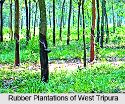
It is said that West Tripura district possessed abundant forest resources and vegetation in the past, which is now being threatened due to increase of the local population as well as indiscriminate deforestation. Such human activities which include `Jhum` cultivation have rendered large tracts of land area infertile and susceptible to soil erosion. Rubber plantation which was introduced here was quite successful since this crop derived the optimum temperature and soil conditions necessary for its survival. Today West Tripura reaps the benefits of a thriving economy which contributes to the overall economic growth of the State. The State Government is promoting the development of rubber cultivation by providing a public service enterprise named Tripura Forest Development and Plantation Corporation Limited. West Tripura district is also known for its coffee plantations. The inhabitants of the remote forest locales of West Tripura district depend on the supply of firewood for domestic utility. Therefore this is also among the significant sources of income for the regional people dwelling here.
Rivers of West Tripura District
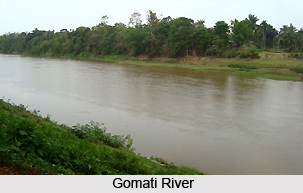
Gomati River is one of the principal rivers which flows through the district, which is created by the confluence of two rivulets named Sarma and Raima. While the source of Sarma is Atharamura range and Raima originates from Longtharai range, both these rivulets meet each other near the region of Dhuchaibari along the boundary of South Tripura district. Thereafter, it assumes the name of `Gomati Nadi` after which it enters the sub divisions of Udaipur and Amarpur, South Tripura before finally entering Sonamura sub division which is situated in West Tripura district. Ekchhari, Chelagang, Rambhadhachhara, Ranigan, Maharanichhara and Kurmachhara are the tributaries of Gomati River on the left bank and the tributaries on the right banks of Gomati River are Noachhara, Sarbongchhara, Saugang, Patavgang, Datakchhara and Labachhara. The Gomati River measures about 166 km in length.
Howrah River is another river flowing across West Tripura whose length is about 53 km. It flows towards the western direction and runs into Bangladesh, after crossing the town of Agartala. It originates from Baramura range and its tributaries on the left bank include Bangeswargang, Dhobatilachhara and Charupanadi. Its right bank tributaries are Debda, Dowaigang and Ghoramara. Burigang River flows towards the western portion of West Tripura and eventually enters the nation of Bangladesh. Its source is the Baramura hills. The land over which this river flows, is extremely fertile and consist of rich alluvial soil which is appropriate for growing various vegetables, jute, paddy, spices and oil seeds.
Administration of West Tripura District
West Tripura District has five sub-divisions namely Sadar, Bishalgarh, Sonamura, Khowai and Teliamura. Further, the administration of West Tripura District consists of 16 Blocks - Mohanpur, Hezamara, Jirania, Mandwi, Bishalgarh, Dukli, Jampuijala, Melaghar, Boxanagar, Kathalia, Khowai, Padmabhil, Tulashikar, Kalyanpur, Teliamura and Mungiakami. It has 10 towns and 274 inhabited villages.
Economy of West Tripura District
Economy of West Tripura District is predominantly agrarian in character. Agricultural situation of West Tripura District differs to some extent from the other districts in regard to topography, soil, extent of rainfall, variation in temperature and humidity which has resulted in difference in cropping pattern also from that of the other two districts. People mainly practice jhum cultivation. The plain land people also were satisfied to grow single crop preferably paddy without having any knowledge and experience of improved method of cultivation for growing multiple crops. Animal husbandry is another sector contributing to the economy of West Tripura District. Cattle and poultry are the main livestock wealth of the district. Due to topographical feature, the fisheries reserves in the district are limited to ponds, tanks, etc.
History of West Tripura District
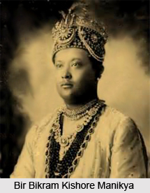 History of West Tripura District speaks about the development of the current-day district, right since the days of its inception and continuing over the period when Tripura was a princely state of India. The very last ruler of the region of Tripura was Bir Bikram Kishore Manikya and following his demise in May 1947, a regency under the supervision of his wife Maharani Kanchanpura Devi seized the reigns of administration of this area. She controlled the area on the behalf of Kirit Bikram Kishore Manikya, who was a minor prince and son of the deceased ruler of Bikram Kishore Manikya.
On 9th September, 1947 monarchy came to an abrupt conclusion. The Chief Commissioner gained control of Tripura and the region was administered as a Part C state. During 1st November, 1956, Tripura became a Union Territory of the nation, while on 15th August, 1959, the Territorial Council of Tripura came into existence. During the month of July in 1963 the Territorial Council dissolved and Legislative Assembly was formed. Eventually, in January 1972, Tripura was declared as an official State. A Collector and a District Magistrate controlled the district until 31st August, 1970. Tripura was soon divided into three different districts namely South Tripura, North Tripura and West Tripura District, in order to ensure better administration of this portion of the country and speeding up the progress of the area, particularly the tribal belts.
From 1st September, 1970, three Collectors and District Magistrates had been appointed to look after Tripura. There were as many as 10 sub-divisions of the one single District Territory. Sonamura, Sadar and Khowai are the various sub-divisions of West Tripura District. Kamalpur, Kailashahar and Dharmanagar are the sub divisions of North Tripura District while the sub divisions of the South Tripura District are Belonia, Udaipur, Sabroom and Amarpur. A portion of Athramura hill ranges and Baramura hills are amongst the six major hill ranges which are included within the boundaries of the district.
Education of West Tripura District
 Education of West Tripura District involves the various educational institutes present here like B.B. Evening College, Agartala, Government College of Education, Agartala, Tripura Government Law College, Agartala and numerable other institutes.
The average literacy rate of the entire district is 41.07. However, the highest literacy rate has measured upto 55.25, which is the literacy rate of eight villages which possessed a population of 10000. The immediate next literacy rate recorded by this district is 45.08, which has been achieved in as many as 34 villages, which consisted of a population of about 5000 to 9999. 13.22 has been the lowest rate of literacy of eight villages involving a population of less than 200 and the second lowest literacy rate is 15.79 which was existent in 14 villages with a population range consisting of 200 to 499. A literacy rate measuring 30.47 and 38.75 were obtained by as many as 106 villages with a range of population of 500 to 1999.
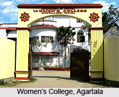
The numerable educational institutes present in West Tripura District are Tripura Engineering College, Agartala, Women`s College, Agartala, M.B.B.S. College, Agartala, Government College of Art and Craft, Agartala, Music College, Agartala, Government Degree College, Sonamura, Tripura University, Agartala and Government Degree College, Khowai.
Festivals of West Tripura District
 Festivals of West Tripura District reflect the indigenous culture and traditions of West Tripura District and involve colourful events like `Poush Sankranti`, `Kali Puja`, `Kharchi Puja`, `Chaitra Sankranti`, `Saraswati Puja`, `Shiv Puja`, `Ker Puja`, `Dol Puja`, `Raslila`, `Durga Puja`, `Charak Puja`, `Burdebta Muharram`, `Rath Jatra`, `First Baisakh`, `Janmashtami`, `Manasa Puja`, `Easterday`, `Good Friday`, `Lakshmi Puja`, `Basanti Puja`, `Bishub Parab`, `Eid-ud-Zuha`, `New Year`s Day`, `Jhulan Jatra`, `Biswakarma Puja`, Christmas, `Nabanna`, `Ganga Puja`, `Bishahari Puja`, `Sitala Puja`, `Garia Puja` and several others.
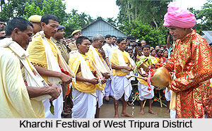
Kharchi Festival
Also referred to as `Chaudda Devata Puja` or `Chaturdash`, Kharchi Festival or Kharchi Puja is one of the few festivals which is observed with a religious fervour and devotion amongst the regional residents of West Tripura District. Old Agartala, which was the second capital of the king Krishna Manikya (and also served as the capital of the previous rulers of Tripura) is the place where the Kharchi festival fair is conducted every year and it is popularly known as `Chaudda Devatas bari` or `Chaturdash Devata`. Chaturdash Devata was worshipped as the family deity by the former rulers of Tripura. When the capital was moved from old Agartala to Agartala, the family deities were not removed from their original positions. During the month of `Ashar` which implies the months of June till July, a grand religious event called `Kharchi Puja` which continues for seven days. This festival is observed on the eighth day of `Suklastami` or the moonlit period.
The idol is composed of stone and placed in a different hut, which is left open on all its sides. The hut is constructed on a pucca platform. The married women of West Tripura District apply vermilion on the parting of their heads and offer lighted candles in front of the deity Burama and pray to Burama, in the hope of obtaining his blessings, in the form of children. It is believed that even if an infertile lady prays to Burama, she would be blessed with an offspring soon. Numerous goats are sacrificed by several religious people and this is the most distinct feature of Kharchi Puja. A special priest known as `Galim` offers this sacrifice. As per the customs of this Puja, the sacrificed beast is offered back to man who has brought the animal to be sacrificed. However, the head of the animal is kept by the Galim. Following the animal sacrifice, a part of the flesh of the animal, along with some of their blood is offered to fourteen gods.
Ker Festival
Ker Puja is celebrated after a fortnight of conducting the Kharchi Puja and is a very popular festival of West Tripura District. This Puja is conducted on a Tuesday or Saturday. The main priest who is responsible for this festival is referred to as `Chantai`, who is the chief of the priests of the region of Old Agartala. The venue of worshipping is called `Ker Chaumuhani` and is located at Agartala. The priest marks this special spot by separating it from the rest of the place with the aide of a bamboo fence. Numerous local tribal villages also participate and arrange this festival, wherein their tribal priest or `Ojhai` performs the principal rites of this festival. `Nagri Pura` is the name of a long bamboo, which is also worshipped during this festival and forms an essential portion of the Ker Festival.
Industries in West Tripura District
 Industries in West Tripura District are scanty and the some of the main minerals present here include natural gas, clay and lignite. Plastic clay is found in a few quantities in this portion of the country and it is utilized for manufacturing pottery crafts and roof tiles. Lignite deposits are also commonly found here, though they do not possess economic significance as they are of inferior quality and are pyritiferous.
A large chunk of the local population is below the poverty line, which is the consequence of an agrarian economy of West Tripura district. Prior to its merging with the Indian Union, this district was entirely devoid of any industrial activities. On 15th October, 1949, Tripura was joined with the Indian Union. From the Second Five Year Plan onwards, industrialization commenced in an amateur way in this area. Several industrial institutions as well as some production-cum-training centers existent in West Tripura provide numerous training programs in various disciplines. The regional residents of this part of India initiated some action in the industrial sector, starting from the Third and Fourth Five Year Plans, particularly in the sphere of small and village
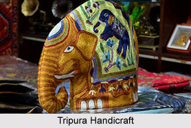
 industries. In the northern, southern and western parts of Tripura, industrial units were offered by the Government of Tripura. In order to encourage entrepreneurs towards developing industries, special incentive schemes were offered by the Government of Tripura. However, the private entrepreneurs were incapable of bringing about much economic growth, despite the contribution of the Government of Tripura. Eventually, the Government launched financial corporations like Tripura Tea Development Corporation, Tripura Handloom and Handicrafts Development Corporation, Tripura Jute Mills Limited and Tripura Industrial Development Corporation to accelerate industrial growth.
The raw materials were supplied to small scale industrial units by the Tripura Small Industries Development Corporation. This organization also supervises the operation of brick kilns, fruit canning, pharmaceuticals and other small scale industries. The department of handloom and handicrafts is taken care of by Tripura Handloom and Handicrafts Development Corporation. Tripura Industrial Development Corporation has been reorganized of late. Presently, new industrial estates have been launched in West Tripura district to control the industrial region. The objective of these industrial estates is to serve as financial bodies.
A significant part of industrial activities have been started at the region of Dukli, which is located near Agartala. Thanks to the efforts of Tripura Tea Development Corporation, the regional tea industry is the most prosperous industry of the region. The State Government has patronized the tea estates of West Tripura district, which were dysfunctional for numerous years. This organization was established in August, 1980, on the Planning Commission`s recommendation to introduce new areas to tea plantations. It aims to transform about 5000 to 8000 acres of land into productive areas which can facilitate the cultivation of tea, within five years.
Tripura Small Industries Development Corporation`s duty is to supply paraffin wax, iron and steel, newsprint, cement G.C.I. and mutton tallow. Innumerable number of people has received employment, due to this organisation.
Tourism in West Tripura District
 Tourism in West Tripura District is made memorable by the rich and diverse flora and fauna, scenic beauty of the hilly terrains, interspersed with splash green valleys in between. These aspects of the district attract the tourists from different parts of the country to find solace in the calmness of the nature. Tourism in West Tripura District includes visits to several historical and religious sites.
Some of the major tourist attractions in West Tripura District are as follows
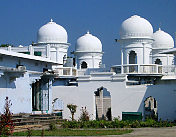
Ujjayanta Palace: At the heart of Agartala stands Ujjayanta Palace, the modern edifice of the royal house of Tripura. The construction of this beautiful palace had to be undertaken in 1899 in spite of the then stringent financial condition of the state because the old palace which was built in 1862 suffered badly from a severe earthquake in 1898. The palace is a two storied mansion having a mixed type of architecture with three high domes. It had well-laid garden parks all around it and two large tanks on two sides.
Kunjaban Palace: A picturesque hillock known as Kunjaban for its scenic beauty stands in the north of Agartala town and within a mile from the Royal Palace (Ujjayanta Palace) with tracts of some law-lying hillocks. Kunjaban palace is one of the main attractions of this place.
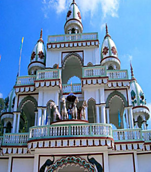
Jagannath Temple: Jagannath Temple at Agartala is attractive for its unique structure being octagonal at the basement. Every pillar of the octagon is crowned by a square pyramidal cone.
Rudrasagar and Nirmahal: Rudrasagar is deep and extensive lake situated about 53 kms from Agartala and about 8 kms from Sonamura town. Nirmahal is one of the finest beauty spots in Tripura. The lake itself very beautiful and it offers options for rowing.
 Shipahijala: It is situated almost at a distance of 20 kms south from Agartala town. There is a natural lake around this place where boating options are available to the tourists. A dense forest all around is a treat eyes. It has a dear park and a mini zoological garden with pythons and peacocks.
Among other places of visit at Agartala, mention may be made of Maharaja Bir Bikram College campus which appears to have been garlanded by a number of lakes, the government Museum, Buddha Temple, Uma Maheswari Temple and Malanch Niwas.
How to Reach West Tripura District
Agartala is connected with Kolkata by airways and the Airport is 10 kms away from the city. The nearest Railway head is Dharmanagar and Agartala is 200 kms away from Dharmanagar Rail head. District headquarter is connected by regular bus services from other two district of the State and important cities such as Kolkata, Dharmanagar, Guwahati and Silchar.
Rivers of West Tripura District
 Rivers of West Tripura district have their origination point in the state of Tripura. The district has long river valleys which spans over huge areas in various sub divisions. These valleys are usually formed of deep alluvial deposits and are highly fertile supporting the cultivation of vegetables, fruits, spices, oil seeds, paddy and jute.
Gomati River
Gomati is the principal river of West Tripura district which is formed by the confluence of two rivulets namely Sarma and Raimas. The Sarma originated from the Atharamura range while the Raimas from the Longtharai range and both meet near Dhuchaibari situated in the of the South Tripura district`s south eastern boundary. After the confluence, the river has been named as Gomati that runs through gorges and reached the Dumbur fall of the Amarpur sub-division. The river has a length of 133 kilometres. It flows through the Amarpur and Udaipur sub-divisions of the district of South Tripura and Sonamura sub-division of the districts of West Tripura. The river then runs towards Bangladesh along the side of Sonamura town of the district of West Tripura. On the right bank, the tributaries of the river include Noachhara, Patavgang, Saugang, Sarbongchhara, Datakchhara and Labachhara while on the left bank it has tributaries namely Ranigan, Maharanichhara, Kurmachhara, Chelagang, Ekchhari and Rambhadhachhara.
 Howrah River
Howrah River originates from the Baramura range. The tributaries of the river on its right bank include Debda, Ghoramara and Dowaigang whereas on the left bank its tributaries are Bangeswargang, Dhobatilachhara and Charupanadi. The river flows through a length of 53 kilometres. The river flows towards the west, passes by the side of Agartala town, and finally enters Bangladesh.
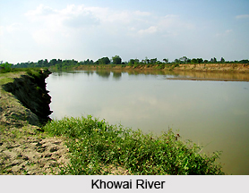
Khowai River
The origin of Khowai River is the Longtharai range. The length of the river is about 166 kilometres. It flows towards north-west and reaches up to Teliamura situated in West Tripura district. It then turns towards north and enters Bangladesh. The tributaries of Khowai River on its right bank are Lalchhara, Samruchhara, Tuirupachhara, Maharanichhara, Baskarachhara Alladiachhara, Chamalachhara, Jeulchhaara and Baluchhara. On its left bank the tributaries of the river include Solaichhara, Gangraichhara, Trishnachhara, Sarduchhara, Brahmachhara, Kakrachhara, Nunachhara and Gulechhara.
Burigang River
Burigang River originates from Baramura, runs towards the west, and finally enters Bangladesh.