Introduction
South Tripura District is one of the four administrative districts of Tripura with its headquarters located at Udaipur. The district is situated approximately between longitude 91 degrees 18 minutes and 91 degrees 59 minutes east and between latitude 22 degrees 56 minutes and 23 degrees 45 minutes north.
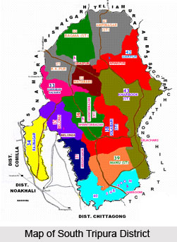 South Tripura District is bounded on the north by Dhalai District and West Tripura District, while on the other sides by international border with Bangladesh. The total geographical area of South Tripura District is 224 sq kms which is about 25 percent of the total area of the state.
South Tripura District is bounded on the north by Dhalai District and West Tripura District, while on the other sides by international border with Bangladesh. The total geographical area of South Tripura District is 224 sq kms which is about 25 percent of the total area of the state.History of South Tripura District
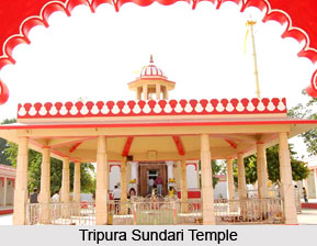
South Tripura District with its headquarters at Udaipur was created in the year 1970. Udaipur, Tripura is popularly known as the city of lakes and was the capital of Tripura till 1760. The city is famous for its Mata Tripura Sundari Temple which is situated about 3 km away from Udaipur at Matabari.
Geography of South Tripura District
Geography of South Tripura District comprises three principal hill ranges. South Baramura and Deotamura hill ranges are completely in South Tripura District while a part of Atharamura hill range also comes in the district. Deotamura is the principal hill range of South Tripura District having a length of 85 kms and forms the boundary between Amarpur and Udaipur Sub-Division. Climate of this district is mostly warm and is characterized by a humid summer and a dry cool winter with plenty of rains during July to October. Rainfall is received from the South-West Monsoon, which normally breaks in the month of May. Autumn and spring seasons are of very short duration. Average annual rainfall in the district is about 2000 mm and the temperature varies between a maximum of 35.23 degree Celsius and a minimum of 7.43 degree Celsius. Variation in temperature is comparatively lower during rainy season. Major rivers flowing through South Tripura District are Gomti River, Muhuri and Feni.
Demography of South Tripura District
 According to the population census in the year 2011, South Tripura District had population of 875,144 of which male and female were 447,124 and 428,020 respectively. The population of South Tripura District constituted 23.84 percent of total population of Tripura. The average literacy rate of South Tripura in 2011 was 85.41 percent compared to 69.90 of 2001. If things are looked out at gender wise, male and female literacy were 90.94 and 79.64 respectively. The total literate in South Tripura District were 654,503 of which male and female were 355,784 and 298,719 respectively. In 2001, South Tripura District had 459,502 in its district. Major tribes in the district are Tripuri tribe, Jamatia tribe, Reang, Chakma tribe and Halam tribe. Language spoken by majority of the population is Bengali language while the tribal communities mainly speak Kokborok language.
Economy of South Tripura District
Economy of South Tripura District is agrarian as agriculture is the main occupation of the majority of the population. However, only 31.61 percent of the land in the district is cultivable. Paddy is the main food crop grown in the district. Potato, sugarcane, jute, mustard, etc. are some other crops grown in this district. Tea, coffee, rubber, jackfruit, banana, mango, pineapple, etc. are the major plantation
Tourism in South Tripura District
 Tourism in South Tripura District includes exploring of various historical sites, temples and nature parks. The charming beauty of the region adds value to the tourism experience of the visitors. People from all parts of the country come to explore the several sightseeing options offered by the district.
Some of the popular attractions of South Tripura District are as follows -
Tripura Sundari Temple: The temple is situated at about 3 kms away from Udaipur, Tripura. The temple was constructed in 1501 AD during the period of Maharaja Dhanyamanikya. It is one of the most important tourist spots of the state where hundreds of pilgrims visit every day. During Diwali, a big fair is organized in the temple premises. According to legends, this temple was constructed for establishing idol of Lord Vishnu.
Bhuvaneswari Temple: The temple is situated on the northern bank of Gomti River. The temple was built in between 1667 to 1676 AD, during the reign of Maharaja Govinda Manikya. The temple is constructed on a 3 feet high paved terrace. The roof of the temple features the typical four-chaala pattern with stupa like crowns on the vestibule and core chambers. The stupa on core chamber is embellished with floral designs. This temple has some historical importance associated with it.
Shib Bari: The temple is situated at Udaipur town. The temple was constructed by Maharaja Dhanya Manikya. The door of the temple faces the west. The temple was repaired in 1651 AD by Maharaja Kalyan Manikya.
Tin Mandir: This temple is situated by the east bank of Jagannath Dighi. The temple has stone-inscriptions. Perhaps it was built some time in the last quarter of the 17th century.
 Debatamura: Debatamura is located approximately 35 kms away from Udaipur; it is situated in Amarpur Sub-Division. Debatamura means God`s peak and it is a fall range between Udaipur and Amarpur Sub-Division running along the Gomti River. The place is famous for images of Lord Shiva and Goddess Durga. The hill ranges are covered with thick jungles and one can reach this abode of gods only after trekking through these jungles.
Pilak: The place is about 55 kms away from Udaipur. It is situated in Belonia Sub-Division. Pilak is considered as a significant historical site as several old stone images have been found in this area.
Tirthamukh: It is situated about 62 km away from the district headquarters. The place is famous for its serene beauty and tranquility. The famous Dumbur Hydel Project is situated here which is the main source of power for South Tripura District. Two rivers Raima and Sarma which originate in Dhalai District merge here and the famous Gomti River originates from this Dumbur reservoir at Tirthamukh. The Dumbur Reservoir is also famous for attracting a large number of birds from different parts of the world.
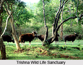
Trishna WildLife Sanctuary: It is situated approximately 60 kms away from the district headquarters in the western part of Belonia Sub-Division. It is famous for migratory birds from Siberia and other places in winter.
Deer Park and Patichari: It is situated at Patichari and is famous for the abode of spotted deer and barking deer.