
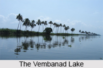
 Vembanad Lake located in Kerala, is the longest lake in India and the largest lake in the state of Kerala. In fact, it is one of the largest lakes in India. It is known as Punnamada Lake in Kuttanad and Kochi Lake in Kochi. The northern extension of Vembanad Lake from Kochi Azhi to Munambam Azhi, that is, the serene backwaters is popularly known as Veeranpuzha. The Government of India has placed the Vembanad Wetland under National Wetlands Conservation Programme. The Vembanad Wetland System was included in the list of wetlands of international importance in 2002 as defined by the Ramsar Convention. It entered the list with the aim to conserve and promote sustainable utilization of wetlands. It is the largest of the three Ramsar Sites in the state of Kerala. This lake comes alive during Onam with a spectacular water regatta - the snake boat races. Hundreds of oarsmen in one boat slice their way through the waters with full throated singing, offering viewers a spectacular site.
Vembanad Lake
Vembanad Lake covers an area of about 200 square kilometers and is the largest brackish lagoon in India.
Introduction
Vembanad Lake located in Kerala, is the longest lake in India and the largest lake in the state of Kerala. In fact, it is one of the largest lakes in India. It is known as Punnamada Lake in Kuttanad and Kochi Lake in Kochi. The northern extension of Vembanad Lake from Kochi Azhi to Munambam Azhi, that is, the serene backwaters is popularly known as Veeranpuzha. The Government of India has placed the Vembanad Wetland under National Wetlands Conservation Programme. The Vembanad Wetland System was included in the list of wetlands of international importance in 2002 as defined by the Ramsar Convention. It entered the list with the aim to conserve and promote sustainable utilization of wetlands. It is the largest of the three Ramsar Sites in the state of Kerala. This lake comes alive during Onam with a spectacular water regatta - the snake boat races. Hundreds of oarsmen in one boat slice their way through the waters with full throated singing, offering viewers a spectacular site.Geography and Hydrography of the Vembanad Lake
The Vembanad Lake is a part of Vembanad-Kol Wetland System which extends from Alappuzha in the south to Azheekkode in the north. Situated at sea level, the Vembanad Wetland System covers an area of about 2033.02 km sq. The Vembanad Lake is approximately 14 kilometres wide at its widest point and just over 96.5 km in length. Its boundaries are framed by Alappuzha, Kottayam and Ernakulam districts. The port of Kochi (Cochin) is located at the lake`s outlet to the Arabian Sea. The town of Alappuzha (also known as Allepey), sometimes called the "Venice of the East" for its large network of canals that meander through the town - is located between the lake and the Arabian Sea. On the east coast of the lake, Kumarakom Tourist Village is located. The northern fringes of this village are graced by the Kumarakom Bird Sanctuary. This village offers houseboat cruises and holiday packages.
A narrow barrier island helps this lake in maintaining a distinct identity from the Arabian Sea. This lake is linked by canals to other coastal lakes in the north and south. Kottayam is a vast network of canals which empty into this long lake. 10 rivers flow into Vembanad Lake, out of which 6 rivers belong to central Kerala. They are- Achankovil, Manimala, Meenachil, Muvattupuzha, Pamba and Periyar. This lake is known to provide shelter to more than 20,000 waterfowls - the third largest such population in India. It is also a suitable habitat for shrimps.
A narrow barrier island helps this lake in maintaining a distinct identity from the Arabian Sea. This lake is linked by canals to other coastal lakes in the north and south. Kottayam is a vast network of canals which empty into this long lake. 10 rivers flow into Vembanad Lake, out of which 6 rivers belong to central Kerala. They are- Achankovil, Manimala, Meenachil, Muvattupuzha, Pamba and Periyar. This lake is known to provide shelter to more than 20,000 waterfowls - the third largest such population in India. It is also a suitable habitat for shrimps.
Thanneermukkom Salt Water Barrier in the Vembanad Lake
The Thanneermukkom salt water barrier is located at one of the narrower parts of the Vembanad Lake. It functions as the largest mud regulator in India. It was constructed as a part of the Kuttanad Development Scheme and is near about 1,252 metres (4,108 ft) long. The reason for the construction of this barrier was prevention of tidal action and intrusion of salt water into the Kuttanad lowlands. It divides the lake into two parts - one with perennial brackish water and the other with fresh water from rivers draining into the lake. This salt water barrier has proved to be advantageous in certain ways. It has helped farmers in Kuttanad by freeing the area of salinity and allowing them an additional crop in the dry season. But this barrier also has its disadvantages. A major drawback of this barrier is the loss of opportunity for fishes and prawns to migrate upstream. There has also been an increase in weed growth upstream which consequently prohibits the natural flushing of pollutants.
Hydrography of Vembanad Lake
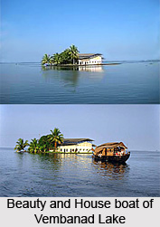 Hydrography of Vembanad Lake covers the extension of the lake in Kerala, and the aquatic lifestyle. Vembanad Lake is the largest brackish lagoon in Kerala. It covers an area of two hundred square kilometres and is surrounded by the districts of Alappuzha, Kottayam and Ernakulam.
Vembanad Lake or Vembanad wetland system is largest wetland system in India. Of this, an area of 398.12 square kilometres is located below the MSL and a total of 763.23 square kilometres area is located below 1 m MSL. Vembanad Lake is bordered by Alappuzha district, Kottayam district, and Ernakulam district. It is situated at the sea level, and is separated from the Arabian Sea by a narrow barrier island. Vembanad Lake surrounds the islands of Pathiramanal, Perumbalam and Pallippuram.
Vembanad Lake is about 14 kilometres wide at its widest point. The lake is a part of Vembanad-Kol wetland system which extends from Alappuzha District in the south to Azheekkode in the north, making it by far, India`s longest lake at just over 96.5 km in length. Vembanad Lake is fed by ten rivers flowing into it including the six major rivers of central Kerala namely the Achenkovil River, Manimala River, Meenachil River, Muvattupuzha River, Pamba River and Periyar River. The total area of the lake is 15,770 square kilometres which accounts for 40 percent of the area of Kerala.
Demography on the Shores of the Vembanad Lake
As estimated, millions of people live on the banks of the Vembanad Lake. People living on the shores of Vembanad lake earn their livelihood by indulging themselves in various activities, which include agriculture, fishing, tourism, inland navigation, coir retting and lime shell collection.
Ecological Crisis faced by the Vembanad Lake
With the aim to form polders and enlarge the extent of the Wellington Island of Cochin port, the Vembanad Lake underwent land reclamation, over the course of the past century. As a result, the water spread area of the Vembanad Lake started reducing considerably from 1971 to 1990, which became a matter of concern for the state. The Thanneermukkom bund is responsible for the rampant propagation of water hyacinth in fresh water. Also, the lake"s bed is heavily exploited for uncontrolled mining of shells. Its adjoining areas including a medical college at Alappuzha is responsible for the release of sewage effluents and organic materials in huge amounts, without any prohibition. As a result, these toxins are decreasing the dissolved oxygen level in the water of this lake.
Tourism of Vembanad Lake
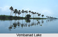 Vembanad Lake is the longest lake in India, and the largest brackish lake in the state of Kerala. Vembanad Lake is also counted as one of the largest lakes in India. Kottayam is a vast network of rivers and canals. These are empting into the great expanse of water called the Vembanad Lake. Vembanad Lake is an enchanting picnic spot and a fast developing backwater tourism destination. Vembanad Lake also provides boating, fishing and sightseeing experiences which are thrilling.
Thannermukkom Salt Water Barrier
Thannermukkom Salt Water Barrier was constructed as a part of the Kuttanad Development Scheme. This barrier was erected to prevent the tidal action and interruption of salt water into the Kuttanad low-lands across Vembanad Lake between Thannermukkom on south and Vechur on north. Thanneermukkom Bund better known as Thannermukkom Salt Water Barrier was constructed in 1974 and is functional since 1976. It is the largest mud regulator in India.
Kumarakom Bird Sanctuary
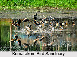 A visit to this bird sanctuary, Kumarakom Bird Sanctuary gives an excitement and pleasure to the tourists who come to visit this lake. This bird sanctuary also set in the Kerala Backwaters is an ornithologist`s paradise and a preferred place of migratory birds. The main residents of this Kumarakom Bird Sanctuary are the waterfowl, cuckoo, owl, egret, heron, cormorant, moorhen, darter, Brahminy kite and the duck, as well as the migratory Siberian crane. Parrot, teal, lark, flycatcher, and other birds are seen here during their respective migratory seasons. Some of the migratory birds come from the Himalayas, and a few from far away Siberia, are also seen this region.
Vembanad Lake Back waters
Punnamada Kayal forms a part of Vembanad Lake, located in Alappuzha District of Kerala. Every year during the Onam festival, Nehru Trophy boat Race is held here. It is the most exciting boat race in which Chundan Vallam, which is known as the snakeshaped long boats with an arching head and with a big number of rowers compete after tough practice. While on a contrary Ashtamudi lake is a large lake with an area of 1700 sq km, has 8 tentacles going into the lush green inland. Water is mineral-rich, so enhances the ecosystem where nearly a 100 varieties of fish live. Birds reside in this place as this place is very conducive.
Recently updated articles in Geography of India

Krishnaveni River
The Krishnaveni River, presently known as the Krishna River, is one of India’s major rivers. Originating in the Western Ghats of Maharashtra, it flows...

Wakal River
The Wakal River is an important tributary of the Sabarmati River, originating in Rajasthan’s Aravalli Range and flowing through Rajasthan and Gujarat....

Pahuj River
Pahuj River is an important tributary of the Sindh River that flows through the Indian states of Madhya Pradesh and Uttar Pradesh. Originating in the...

Arunavati River
Arunavati River is a seasonal right-bank tributary of the Tapi River, flowing through parts of Madhya Pradesh and Maharashtra. Originating in the Satp...

Nira River
Nira River is an important tributary of the Bhima River flowing through Maharashtra. Originating in the Western Ghats, it traverses Pune, Satara, and...
Related articles in Geography of India

Geography of Sikkim
Geography of Sikkim is characterised by a vast array of magnificent hillock that extends from one corner of the state to the other.

Geography of Meghalaya
The suitable climate, highland plateaus, rivers and the flora and fauna together forms the geography of Meghalaya.

Geography of Jammu & Kashmir
Jammu and Kashmir is encompassed by valleys. Some of the dominant valleys of the state are Kashmir Valley, Tawi Valley, Chenab Valley, Poonch Valley,...

Narmada River
Narmada River is regarded as the 5th longest river of India and the life line of Madhya Pradesh. Narmada River basin spreads over an area of about 98,...

Bhima River
The Bhima River is the largest tributary of the Krishna River and is significant in the western and southern Indian states.