Introduction
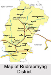 Rudraprayag District is an administrative district of the north Indian state, Uttarakhand. This district has its headquarters located at Rudraprayag. Rudraprayag District is blessed with immense natural beauty, places of religious importance, lakes and glaciers. Internationally known Shri Kedarnath Temple is at its north, Madmaheshwar temple at its east, Nagrasu at its southern east and Srinagar at its extreme south.
History of Rudraprayag District
According to history of Rudraprayag District, this district was established on 16th of September, 1997. The district was carved out from some areas of three adjoining districts. The areas were whole of Augustmuni and Ukhimath block and part of Pokhri and Karnprayag block from Chamoli District. The areas also included part of Jakholi and Kirtinagar block from Tehri Garhwal District and part of Khirsu block from Pauri Garhwal District.
Further, history of Rudraprayag District states that the present Garhwal was known as Kedar Khand in the past. In Puranas Kedar-Khand was said to be the abode of God. It seems from the facts in the Vedas and Indian Puranas, Ramayana and Mahabharata that these Hindu scriptures are scripted in Kedar-Khand. Moreover, it is also said that the roots of Vedic literature seems to be originated from Garhwal because the Garhwali language has a lot of words common with Sanskrit language.
Authentic script about the history of Rudraprayag District is found only 6th AD on word. Some historians believe that this land is the origin of the Arya race. It is believed that about 300 BC Khasas invaded Garhwal through Kashmir, Nepal and Kumaon. A conflict grew due to this invasion and a conflict took place between these outsiders and natives. The natives for their protection built small forts called `Garhi`. Later on Khasas defeated the natives and captured the forts. After Khasa, the Kshatriyas invaded this land and defeated Khasas. They confined Garhwal of hundreds of Garhi in to fifty-two Garhi only. Kantura Vasudev established his regime on the northern border of Garhwal and founded his capital in Joshimath. According to history, Raturi king Bhanu Pratap was the first ruler of Panwar dynasty in Garhwal who founded Chandpur Garhi as his capital.
Moreover, as per historical records the devastating earthquake of 8th of September, 1803 weakened the economic and administrative set up of Garhwal state. Taking advantage of the situation Gurkhas attacked Garhwal. They established there reign over half of the region in 1804 and up to 1815 this region remained under Gorkha rule. Mean while the king of Panwar dynasty Raja Sudarshan Shah contacted British East India Company and asked for help. With the help of British he defeated Gorkhas and merged the eastern part of Alaknanda and Mandakini along with the capital Srinagar in Garhwal under British rule. From that time this region was known as British Garhwal and the capital of Garhwal was set up at Tehri instead of Srinagar. After the death of Sudarshan Shah, Bhawani Shah succeeded him, who died in 1871 and was succeeded by his elder son Pratap Shah. Pratap Shah ascended the throne of Tehri at the age of 21 only. He was the founder of Pratap Nagar. He also tried to improve the forest, judicial and police administration. During his rule several public uprisings took place in the state. He died in the year 1886.
Kirti Shah at the time of his father`s death was still in his teenage years, so his mother Rajmata Guleri appointed Vikram Singh as the regent. But after sometime she took over the administration. Kirti Shah took over charge of the state in 1892. His rule saw a marked improvement in the functioning of courts, forest and other departments. He is said to have invented typewriter for Hindi but gave the copy write to a company. The religious inclination of Kirti Shah is aptly proved by the fact that he organised a religious conference of the followers of different religion at Tehri. He died in the year 1913. Narendra Shah the successor of Kirti Shah was again a minor at the time of succession. Thus, during the initial years the state administration was looked after by Regency under the presidency of his mother.
During the period of Second World War (1939-1942) Tehri state supplied a huge amount of wood to the British rulers while the king himself offered his services for them during the First World War. Some of his achievements were developing the new township of Narendra Nagar, construction of Kirti Nagar, Tehri, Muni ki Reti. He died on 22nd of September, 1950 in a car accident but had already relinquished the throne in favour of his son Manvendra Shah on 26th of May 1946. The later ruled the state from 1946 till the state was merged with the Indian Union in August 1949.
Geography of Rudraprayag District
 Geography of Rudraprayag District mainly includes mountainous terrains. The geology of the region shows that the Himalayas are the young mountains in the world. Most of the hilly section of the range in the district is deeply cut into by the headwaters of Alaknanda River. In some parts of the district uplift has been considerable since the mid-Pleistocene period, in others there are great stretches of high but subdued topography and elsewhere there are the deepest gorges. Physiographically, Rudraprayag District, which lies in a region of tectonic or folded and over thrust mountain chains, has strata and is structurally marked by complex folds, reverse faults, over thrusts and napes of great dimensions.
As the elevation of Rudraprayag District ranges from 800 metres to 8000 metres above see level its climate also varies largely depending on the altitude. The winter season is from about mid November to March. As most of the region is situated on the southern slops of the outer Himalayas, monsoon currents can enter through the valley, the rainfall being heaviest in the monsoon from June to September. During this period around 70 to 80 percent of the annual precipitation is accounted for in the southern half of the district and 55 to 65 percent in the northern half. The effectiveness of the rains is related to low temperature. However, the effectiveness is neither uniform nor even positive in areas where either the vegetation cover is poor and has steep slopes or the soils have been so denuded that their moisture absorption capacity has become marginal.
The details of temperature recorded at the meteorological observatories in Rudraprayag District show that the highest temperature recorded is 34 degree Celsius and lowest is zero degree. January is the coldest month after which the temperature begins to rise till June or July. Temperature varies with elevation. During the winter cold waves in the wake of western disturbances may cause temperature to fall appreciably. Snow accumulation in valleys is considerable. The relative humidity is high during monsoon season, generally exceeding 70 percent on the average. The driest part of the year is the pre monsoon period when the humidity may drop to 35 percent during the afternoon. During the winter months, humidity increases towards the afternoon at certain high stations. Skies are heavily clouded during the monsoon months and for short spells when the region is affected by the passage of western disturbances. During the rest of the year the skies are generally clear.
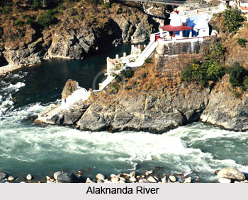
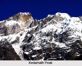 Geography of Rudraprayag District comprises several major rivers and river systems. Mandakini River, which is the most important river coming down from the slopes of Kedarnath peak joins Alaknanda at Rudraprayag. The river actually originates from the springs fed by melting snow of Chorabari glacier about one km above Kedarnath temple. The fact is that the main rivers of the Himalaya are older than the mountains they traverse. All the rivers of the district are snow fed. As the water levels of the rivers are much below the arable land levels, the rivers cannot be generally used for irrigation purposes.
Rudraprayag District is rich in flora and fauna. Moreover, in the warm valleys of the extreme southern part of Rudraprayag District, some species of the trees of the plains such as mango, jamun, Peepul, banyan and shisham up to an altitude of about 915 metres. In Alaknanda valley, the bases, slopes, gorges and tops of the hills up to the height of 1067 metres are well wooded with high trees such as catechu, bahera, har, amaltas, bel, kachnar and dhak. A large variety of creepers some of which have broad green leaves also thrive iin in the vicinity of the trees. Above an elevation of 3439 metres Moru or Tilonj and Kharasu grow and their timber is also used for manufacturing agricultural implements. The chief varieties of timber trees found in the groves of the district are pine, tun, deodar and many varieties of walnut. Many medicinal blooms, herbs and plants, greatly valued in Ayurveda grow in the district. Most of the flowers and plants come up during the rains but wither away from October to May, imparting the characteristic brown colour to the countryside during the winters.
Several important minerals are found in Rudraprayag District are found. Asbestos, Soapstone or Steatite, Copper, Iron, Graphite, Gypsum, Lead, Slate, Building Stone and Sulphur are the main minerals found here. Other minerals found in the district are Antimony, Arsenic, Lignite or Brown Marble, Mica and silver.
Climate of Rudraprayag District
The climate of Rudraprayag District varies as per the different elevations of the district. Mostly it is moderate. The maximum rainfall is received during June to September.
Demography of Rudraprayag District
According to the Population Census in the year 2011, Rudraprayag district has a population of 236,857. Rudraprayag District has a population density of 119 inhabitants per square kilometer.
Culture of Rudraprayag District
 Culture of Rudraprayag district is a blend of different customs and lifestyles. A variety of traditions and beliefs are prevalent in the district which have formed an integral aspect of the district culture. Diverse festivals are celebrated in the district in which people belonging to different faiths participate with equal vigour. The attires of people are chosen according to the environment and availability. The same trend is however witnessed in case of food habits also which are adopted by the people according to the climate and production. Different and vibrant cultural practices of the district significantly contribute into the cultural diversity of the country and enrich its cultural heritage.
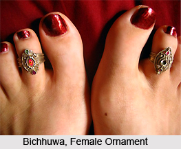 Food of Rudraprayag District
Food habits of Rudraprayag district do not exhibit much uniqueness and is quite similar to other parts of the country. Vegetarianism is prevalent. Staple grains are usually consumed by the people including wheat and rice. Jhanjora, mandua and maize are the coarse grains and are usually taken by the poorer sections. Main pulses consumed in the district are masor, lopia, tur, soontha, bhatt, gahat and urad. People belonging to Hindu religion prefer vegetarian diet whereas Sikhs, Christians and Muslims are habitual of non vegetarian diet.
Jewellery of Rudraprayag District
People of Rudraprayag district are fond of wearing traditional jewelleries which showcases a unique aspect of their culture. Toe rings of silver, also known as Bichhuwas, are the ornaments of married women. Small studs or Keels are worn on the left nostril. Other ornaments which are common among the women and girls of the district include Naths (nose rings), Hansulis (jewellery worn round the neck) and Chandanhar (necklaces). Earrings of silver or gold are also worn. The jewelleries are often embellished with coins, colourful beads or claws and teeth of the panther. Women further adorn themselves with silver amulets which are set with Turquoise. These are worn around arms and necks. Copper or silver Anklets are worn specially by the married women. Silver and gold bangles are also common. Bhotiya women of the district are fond of Ivory Jewellery. Among the men, gold or silver chains and rings are common.
Dresses of Rudraprayag District
People of Rudraprayag district wear dresses that suits to their economy and hilly environment. The common dresses of men include Kurta - Pajama and shirt. Sadri is the term for jacket which is worn by the men. A knee length coat is also the preferred attire for men during winters. However, modern and western attires are also becoming a common choice of the district folks. Women usually wear saris. During winters they wear Angra, which is a kind of jacket. Salwar Kameez is also worn by the women. The Bhotiyas who dwell in hilly regions usually wear woollen clothes. Ghagra (a long skirt), Angras and Phantu (coloured scarf) along with Kamarband (a soft decorative belt) and Orhni (a long scarf) form the traditional attire of women of rural areas.
Fairs and Festivals of Rudraprayag District
Fairs and festivals of Rudraprayag district, Uttarakhand, enrich the cultural heritage of the district in a diverse manner. A plethora of festivals pertaining to different faiths are celebrated with great religious fervour and enthusiasm. Cultural programs also accompany these festivals which add to the spirit of celebrations. A number of fairs also form the major attractions of the district. Their grandeur is worth witnessing and allures people from distant places to participate in these vibrant traditions of the district.
Festivals of Rudraprayag District
Rudraprayag district hosts the celebration of several festivals accompanied with unique customs and rituals. They are the representatives of the rich cultural heritage of the state.
Ramnavami
Ramnavami is observed on the ninth day of bright half of Chaitra month in Hindu calendar. It is the celebration of the birthday of Lord Rama. Fast is observed throughout the day by the followers and devotees of Lord Rama. Social gatherings are also arranged where Ramayana is read and recited.
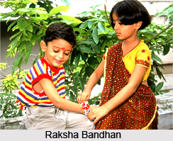
Raksha Bandhan
Raksha Bandhan is celebrated on the last day of Sravana month and is mainly associated with the Brahmanas. Rakshasutra or the thread of protection, commonly known as Rakhi, is tied on the wrist of brothers by the sisters. This symbolizes the protection that she expects to receive from her brother. On this occasion, fairs are organized in Nandprayag, Karnaprayag and Kedarnath.
Nagpanchmi
Nagpanchmi is another significant festival of the district, observed on the fifth day of bright half of Sravana month. It is celebrated to please the serpent gods or Nagas. On wooden floors, images of snakes are drawn which are then worshipped with offerings of milk, rice and flowers.
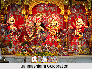
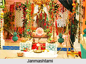 Janmashtami
Janmashtami is the celebration of the birth of Lord Krishna. It is observed on the eighth day of dark half of Bhadra month. During this festival, the devotees fast throughout the day which is broken at the midnight with a visit at temples. The shrines and cradles are beautifully embellished and illuminated at homes and temples to commemorate the birth of Lord Krishna. Devotional songs are also performed during the celebrations.
Diwali
Diwali is also celebrated in the district with great fervour on the last day of dark half of Kartika month. Houses are beautifully illuminated and the worship of Goddess Lakshmi is performed. The celebrations usually commence two days before, from Dhanteras when people purchase metal utensils followed by Naraka Chaturdashi with lightening of small earthen lamps. `Mela nritya`, which is a kind of folk dance, is also performed in the district on Diwali.
Dussehra
Dussehra is celebrated to symbolize the victory of Lord Rama over Ravana and Navaratri is celebrated in the preceding nine days. Ramlila celebrations can be witnessed in different parts of the district especially at Kalimath.
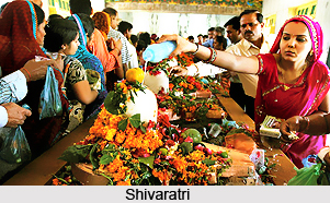
Shivaratri
Shivaratri is celebrated in the honour of Lord Shiva. Fasting is done by the devotees throughout the day and the deity is worshipped at night. Shiva temples are elaborately decorated and water and flowers are offered to the images of the deity along with devotional songs. Grand fairs are held in the district especially at places like Nagnath, Gopeshwar, Bairaskund and Dewal.
Makar Sankranti
Makar Sankranti is observed in the month of January when people take holy bath in the Alaknanda River. Fairs are also organized at Nandprayag and Karnprayag.
Holi
Holi is the festival of colours observed on the full moon day of Phalguna month. The festival is marked by gaiety and merriment among the people.
Fairs of Rudraprayag District
Important fairs of Rudraprayag district include Bishwat Sankranti at different regions, Gaucher Mela at Gaucher, Nautha at Adbadri, Nanda Devi at Bedni, Naumi at Hariyali, Nagnath at Dewar Walla and Dattatreya Pooranmasi at Ansuya temple.
Festivals of Rudraprayag District
Rudraprayag district hosts the celebration of several festivals accompanied with unique customs and rituals. They are the representatives of the rich cultural heritage of the state.
Ramnavami
Ramnavami is observed on the ninth day of bright half of Chaitra month in Hindu calendar. It is the celebration of the birthday of Lord Rama. Fast is observed throughout the day by the followers and devotees of Lord Rama. Social gatherings are also arranged where Ramayana is read and recited.
Raksha Bandhan
Raksha Bandhan is celebrated on the last day of Sravana month and is mainly associated with the Brahmanas. Rakshasutra or the thread of protection, commonly known as Rakhi, is tied on the wrist of brothers by the sisters. This symbolizes the protection that she expects to receive from her brother. On this occasion, fairs are organized in Nandprayag, Karnaprayag and Kedarnath.
Nagpanchmi
Nagpanchmi is another significant festival of the district, observed on the fifth day of bright half of Sravana month. It is celebrated to please the serpent gods or Nagas. On wooden floors, images of snakes are drawn which are then worshipped with offerings of milk, rice and flowers.
Janmashtami
Janmashtami is the celebration of the birth of Lord Krishna. It is observed on the eighth day of dark half of Bhadra month. During this festival, the devotees fast throughout the day which is broken at the midnight with a visit at temples. The shrines and cradles are beautifully embellished and illuminated at homes and temples to commemorate the birth of Lord Krishna. Devotional songs are also performed during the celebrations.
Diwali
Diwali is also celebrated in the district with great fervour on the last day of dark half of Kartika month. Houses are beautifully illuminated and the worship of Goddess Lakshmi is performed. The celebrations usually commence two days before, from Dhanteras when people purchase metal utensils followed by Naraka Chaturdashi with lightening of small earthen lamps. `Mela nritya`, which is a kind of folk dance, is also performed in the district on Diwali.
Dussehra
Dussehra is celebrated to symbolize the victory of Lord Rama over Ravana and Navaratri is celebrated in the preceding nine days. Ramlila celebrations can be witnessed in different parts of the district especially at Kalimath.
Shivaratri
Shivaratri is celebrated in the honour of Lord Shiva. Fasting is done by the devotees throughout the day and the deity is worshipped at night. Shiva temples are elaborately decorated and water and flowers are offered to the images of the deity along with devotional songs. Grand fairs are held in the district especially at places like Nagnath, Gopeshwar, Bairaskund and Dewal.
Makar Sankranti
Makar Sankranti is observed in the month of January when people take holy bath in the Alaknanda River. Fairs are also organized at Nandprayag and Karnprayag.
Holi
Holi is the festival of colours observed on the full moon day of Phalguna month. The festival is marked by gaiety and merriment among the people.
Fairs of Rudraprayag District
Important fairs of Rudraprayag district include Bishwat Sankranti at different regions, Gaucher Mela at Gaucher, Nautha at Adbadri, Nanda Devi at Bedni, Naumi at Hariyali, Nagnath at Dewar Walla and Dattatreya Pooranmasi at Ansuya temple.
Economy of Rudraprayag District<
Rudraprayag District is fully dependent on tourism and temples. But, there are some secondary industries. Rudraprayag District is also rich with mineral resources. Here, the humidity is relatively high especially during the monsoon season. Asbestos, Soapstone, Copper, Iron, Gypsum, Lead, Slate, Building Stone, Sulphur, Antimony, Arsenic, Lignite or Brown Marble, Mica and silver are some of the useful minerals found in Rudraprayag District.
Tourism in Rudraprayag District
 Tourism in Rudraprayag District offers the travellers the scope of experiencing the amazing discovery of nature`s bounties tucked away securely in the hills. This region of Uttarakhand with gushing rivers, majestic snow-clad peaks, enchanting lakes and a rich plethora of flora and fauna is described as the `Abode of Gods`. Thus, quite naturally the blissful air of divinity and picturesque beauty that envelope the Himalaya Mountains lends it a touch of paradise. The most popular places of interest in Rudraprayag District are mentioned below.
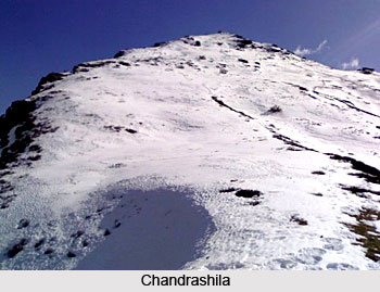
Chandrashila: Chandrashila is the most accessible peak of the Himalayas of this region, at an altitude of 3679 metres, especially since most of the peaks are difficult to scale. This combines scaling, skiing and trekking through a route of rich flora and fauna, lakes, meadows full of fresh snow in the winter months. Chandrashila peak itself provides a rare panoramic view of innumerable snow clad peaks which is simply breath-taking.
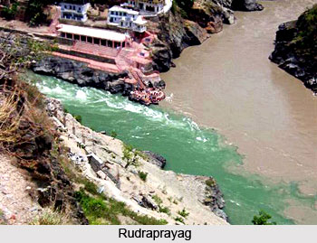 Rudraprayag: Named after Lord Shiva (Rudra), Rudraprayag is situated at the holy confluence of Alaknanda River and Mandakini River, at a distance of 34 kms from Srinagar (Garhwal). The meeting of the Mandakini and Alaknanda rivers has a unique beauty of its own. It is believed that to master the mysteries of music, Lord Narad worshipped Lord Shiva, who appeared in his Rudra Avtaar (incarnation) to bless Narad Muni. Here, the Shiva and Jagdamba temples are of great religious importance.
Augustmuni: 18 kms from Rudraprayag, at an altitude of 1000 metres and on the bank of river Mandakini, this is the place were Rishi Agastya meditated for years. A temple by the name of Agasteshwar Mahadev is dedicated to sage Agastya and this temple is also of archaeological significance; figures of Gods and Goddess have been carved out on stones. On the occasion of Baisakhi a large fair is held and many devotees come here to worship and pay their homage to God.
Guptkashi: Guptkashi has a great importance quite like that of Kashi. The ancient Vishwanath temple, Ardhnareshwar temple and Manikarnik Kund, where Ganga River and Yamuna River are believed to meet, are the main places of attraction in Guptkashi. Guptkashi is situated at an elevation of 1319 metres.
Son Prayag: At an elevation of 1829 metres and on the main Kedarnath route, Son Prayag lies at the confluence of river Basuki and river Mandakini. The holy site of Son Prayag is of immense religious significance. It is said that a mere touch of the holy water of Son Prayag helps one to attain the "Baikunth Dham". Kedarnath is at a distance of 19 kms from Son Prayag. Triyuginarayan, another sacred place, is located at a distance of 14 kms from here.
 Khirsu: The snow covered mountains of Khirsu offers a panoramic view of the central Himalayas and attracts a large number of tourists. From here one can get a clear view of many named and unnamed peaks. Located 19 kms away from Pauri at an altitude of 1700 metres, Khirsu is a peaceful spot, free from pollution. The tranquility of the adjoining thick Oak and Deodar forests is broken only by chirping of birds. The ancient temple of Ghandiyal Devta in the vicinity is well worth a visit.
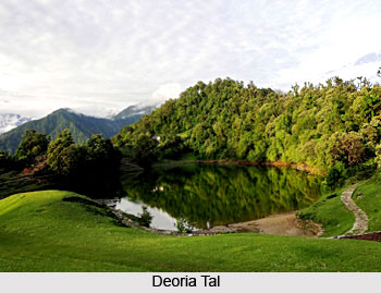
Deoria Tal: It is situated about 2 kms from Sari village. This lake has captivating surroundings with forests all around. The reflection of the mighty Chaukhamba peak in the lake creates a beautiful effect.
Chopta: Chopta is one of the most picturesque places in the entire Garhwal region. It provides a breathtaking view of the Himalayan ranges and surrounding areas.
Sandhi Sarovar: A small lake from where Yudhishthira is believed to have departed to heaven is known as Gandhi Sarovar.
Vasuki Tal: Vasuki tal is 8 kms from Kedarnath, at a height of 4135 metres. The lake is surrounded by high mountains and offers an excellent view of the Chaukhamba peak.
Kedarnath Wildlife Sanctuary: It is located in the northern part of the district and covers an area of 966 sq kms. The area is unique in diverse flora and fauna.
Pilgrimage Tourism in Rudraprayag District
 Pilgrimage tourism in Rudraprayag District is a memorable and enriching experience as it offers several ancient temples that are worth visiting. Three of the `Panch Kedars` are located here. According to legend, Kedarnath, the chief seat of Panch Kedar, came into being during the period when Pandavas were asked to seek Lord Shiva`s blessing. In Rudraprayag District, most of the temples are dedicated to Lord Shiva. Some of the main pilgrimage sites to be explored in Rudraprayag District are as follows.
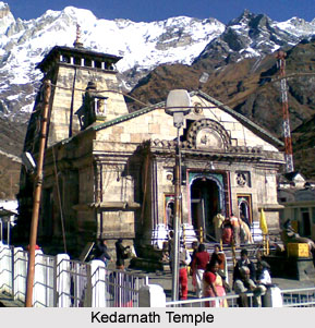
Kedarnath: With the stunning background of towering snow clad mountains, Kedarnath temple presents an enchanting sight. All around it is an aura of peace and purity. The temple of Kedarnath is considered to be more than a thousand years old. The temple is magnificent in its style and architecture. The temple of Sri Kedarnath is situated at an altitude of 3581 metres above sea level. At the entrance is the statue of the "Nandi". The walls inside the temple are exquisitely carved with images. Places which can be visited from here are the Bhairav temple, Samadhi of Adi Shankaracharya and Gandhi Sarovar. Vasukital, yet another beautiful lake is situated at a distance of 8kms from Kedarnath.
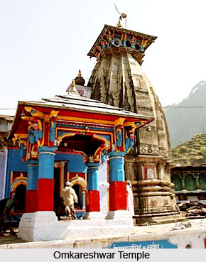
Omkareshwar Temple: Omkareshwar temple at Ukhimath features a beautifully crafted and carefully maintained icon of Lord Shiva. Several popular legends are associated with this temple. Ukhimath is dotted with temples dedicated to Goddess Usha, Shiva, Parvati, Aniruddha and Mandhata. Located nearby is Deoria Tal, which catches the reflection of the Badrinath peak mirroring its grandeur.
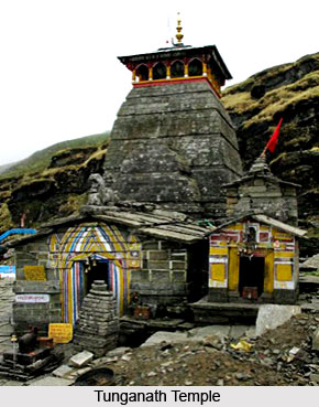
 Tungnath Temple: The Tungnath temple is situated at the height of 3680 metres atop Chandranath parvat. In this temple of Lord Shiva where the dome spans sixteen doors, a 2.5 feet tall idol of Shankaracharya is located along side the lingam. The Nanda Devi temple is also situated at Tungnath not far from the awe-inspiring Akash Ganga water fall. The spectacular Chaukhamba, Kedarnath and the Gangotri-Yamunotri peaks add to the splendor. A popular legend says that Rishi Vyas told the Pandavas that they were guilty of killing of their own relatives and their sins would be expiated only if Shiva pardoned them. Lord Shiva kept avoiding them as he knew that Pandavas were guilty. So the Lord took refuge underground and later, his body parts resurfaced at five different places. These five places, where five magnificent temples of Lord Shiva stand, are known as the "Panch Kedar". Each one is identified with a part of his body. Tugnath is where his hands were supposedly seen. Kedarnath, his hump; Rudranath, his head; Kalpeshwar, his hair; and Madmaheshwar, his navel.
Madmaheshwar Temple: This Shiva temple is the second `Panch Kedar`. This temple is beautifully located amidst serene environs. The temple remains close for six months during winter when the silver idols are taken ceremonially to Ukhimath for worship.
Triyuginarayan Temple: This magnificent temple dedicated to Lord Vishnu, lies in the village of Triyuginarayan. It is similar in architectural style with the temple of Kedarnath making this village an important pilgrimage centre. According to a legend, Triyuginarayan was the capital of the legendary Himavat. There are three other kund in this village, Rudra kund, Vishnu kund and Brahma kund.
 Hariyali Devi: A route diverting from Nagrasu, on the main Rudraprayag Karnprayag route, leads to the Siddha Peetha of Hariyali Devi. It is 22 kms from Nagrasu which in turn is 37 kms from the main town of Rudraprayag. At an altitude of 1400 metres this place is surrounded by peaks and thick forests. On the occasions of Janmashtami and Diwali this place is visited by thousands of devotees.
Koteshwar Temple: At a distance of 3 kms from Rudraprayag and on the holy bank of Alaknanda River is situated the Koteshwar temple. The Koteshwar temple is in the form of cave temple. There are many idols which have been formed naturally. It is believed that before going to Kedarnath, Lord Shiva meditated here. During the months of August and September, thousands of devotees come here for offering prayers.
Kalimath: Kalimath is situated close to Ukhimath, and Guptakashi. It is one of the "Siddha Peethas" of the region and is held in high religious esteem. The temple of Goddess Kali located here is visited by a large number of devotees throughout the year.
Kartikswami: 38 kms from Rudraprayag is a village Kanak Chauri from where 3 kms trek leads to Kartikswami. This place has a temple and idol of Lord Shiva`s son Kartikeya, situated at an elevation of 3048 metres, the place abounds in natural beauty and one can have a close and panoramic view of the Himalayan peaks.
Indrasani Mansa Devi Temple: The temple is situated in village Kandali Patti at a distance of 14 kms from the main town of Rudraprayag and at about 6 kms from Tilwara. It is believed to have been constructed in the age of Adi Shankaracharya. The temple has unique architecture surrounded by temples of Jal kedareshwar and Jakh Devta.
These religious sites offered by Rudraprayag District are worth a visit and they attract a large number of devotees from far and wide.


