 Under the British East India Company constructive steps were taken to improve the existing Indian postal service. They opened the first post office in erstwhile Bombay in 1688 followed by similar ones in Calcutta and Madras. During the time of the British Empire, around 1861, there were 889 post offices handling nearly 43 million letters and over 4.5 million newspapers annually.
It was during this period, that Scinde Dawk was issued, the first adhesive stamp which was produced in Asia by Sir Bartle Frere, the then Governor of Scinde. These postage stamps were issued on 1st July, 1852 but were discontinued from October 1854.
Reforms of 1854 and the First Issues
After Scinde Dawk, the first valid postage stamps were issued on October 1854 with 4 values: ½ anna, 1 anna, 2 annas and 4 annas. All these 4 values were printed in Calcutta and featured the youthful profile of Queen Victoria. These postage stamps were issued without perforations or gums and were all lithographer except for the 2 annas green, which was produced by typography from copper clichés or from electrotyped plates. On the other hand, the illustrated 4 annas stamps were one of the world"s first bi-coloured stamps, which were preceded by the tri-colour Swiss stamp called Basel Dove.
Before the introduction of these 4 value stamps, the British government had already attempted a ½ anna vermillion stamp in April 1854. These stamps were known as the 9½ arches essay but unfortunately they could not be produced in quantity because it required an expensive vermilion pigment, which was not readily available from England, and the substituted Indian pigment destroyed the printing stones.
The earlier practise of conveying official letters free of postage was abolished and this new system of postage stamps was recommended by Lord Dalhousie, the Governor General of India. These stamps introduced a low and uniform rate for sending mail efficiently throughout the country within the jurisdiction of the East India Company. The purpose of these stamps was to show that the postage was prepaid, which eventually became the basic principle of the new system. These reforms transformed the mail service within India.
 More new designs were introduced, the De La Rue printed design of Queen Victoria in an oval vignette inside a rectangular frame was issued on 1855. These stamps had the inscribed words of "EAST INDIA POSTAGE" around the oval vignette of Queen Victoria. These stamps continued in use well after the British government took over the administration of India in 1858, following the 1857 Rebellion against the East India Company`s rule. From 1865, the Indian stamps were printed on paper watermarked with an elephant`s head.
Reforms of 1866 and the Provisionals
After the Post Office Act XIV, new reforms were introduced by 1st May, 1866 to rectify few of the apparent postal system deficiencies and abuses. The new regulations removed the special postal privileges enjoyed by the East India Company officials. The stamps for official use were prepared and carefully accounted for to combat the abuse of privileges by officials. In 1866, India became the first country to adopt the simple expedient of overprinting "Service" on postage stamps and "Service Postage" on revenue stamps.
In later years, this innovation became widely adopted by other countries as well. Due to shortages, these stamps also had to be improvised and new designs for the 4 annas and 6 annas 8 pies stamps were issued in 1866. The provisional 6 annas stamps were improvised by cutting the tops and bottoms from a current Foreign Bill revenue stamp, and overprinting "POSTAGE".
From 1874 to 1876, four new designs were issued and a complete new set of stamps was issued in 1882 for British India. The designs consisted of the usual Victoria profile, in a variety of frames, inscribed "INDIA POSTAGE". The watermark of the stamp was also changed to a star shape. These stamps were heavily used and are still quite common today. In 1895, 3 stamps in 2, 3 and 5 rupee denominations were introduced. These stamps featured a detail from Heinrich von Angeli`s 1885 portrait of Queen Victoria. The other existing designs of these stamps were reprinted in new colours in 1900.
Postage Stamps from Early 20th Century
From 1900 onwards, a new generation of postage stamps came in the market. The new series of 1902 depicted King Edward VII with the reused oval vignette frames of Queen Victoria and some colour changes. These stamps included values up to 25 rupees and the higher values were often used for the payment of telegraph and parcel fees.
The 1911 stamps of King George V were more florid in their design but the first pictorial stamp did not appear until 1931. It was a set of 6, showing the picture of Purana Quila of Delhi along with government edifices which were issued to mark the government`s move from Calcutta to New Delhi. In 1935, another set of pictorial stamps were issued featuring buildings that commemorated George V"s silver jubilee in the same year.
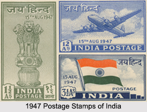
The stamps from 1937 depicted various forms of transportations and while the stamps from 1941 were constrained by the austerity of World War II and consisted of rather plain design using minimal amounts of ink and paper. In 1946, a victory issue stamp was produced followed by the November 1974 Dominion issue. The 1947 issue had three stamps, which were the first to depict the Ashoka pillar, the Indian National Flag and an aeroplane.