 Shimoga district, located almost centrally on the map of Karnataka, is a beautiful sight, dotted with waterfalls, swaying palms and lush paddy fields. Known as the rice bowl of the state, the luxuriant greens of the Shimoga district are inundated by the Tungabhadra, Sharavathi, Varada and Kumudavathi rivers. Shimoga was established by the Keladi rulers, and it has subsequently been home to some of the greatest Indian dynasties, including the Chalukyas, Rashtrakutas, Gangas and others. Shimoga today is much more than a mere tourist destination. Its rich tradition in education, fine arts and culture remain deeply etched in its people and place. It is an enchanting place that welcomes people with the beautiful natural scenery of hills, hillocks and green dales, rivers and streams, dense forests, flora and fauna, forts, temples and historical places, sandalwood and spices, and tops it up with its mouth-watering cuisine.
Shimoga District
Shimoga District is located in the Malnad region of Karnataka state; it is home to the world-famous Jog Falls.
Introduction
Shimoga district, located almost centrally on the map of Karnataka, is a beautiful sight, dotted with waterfalls, swaying palms and lush paddy fields. Known as the rice bowl of the state, the luxuriant greens of the Shimoga district are inundated by the Tungabhadra, Sharavathi, Varada and Kumudavathi rivers. Shimoga was established by the Keladi rulers, and it has subsequently been home to some of the greatest Indian dynasties, including the Chalukyas, Rashtrakutas, Gangas and others. Shimoga today is much more than a mere tourist destination. Its rich tradition in education, fine arts and culture remain deeply etched in its people and place. It is an enchanting place that welcomes people with the beautiful natural scenery of hills, hillocks and green dales, rivers and streams, dense forests, flora and fauna, forts, temples and historical places, sandalwood and spices, and tops it up with its mouth-watering cuisine.Location of Shimoga District
Shimoga district is situated in the Malnad region of Karnataka state. It is bounded by the Sahyadri Ghats, and surrounding it on the North, East, West and South are Haveri, Davangere, Udupi-Karwar and Chikmagalur respectively. Shimoga district stands at a mean elevation of 640 metres above MSL. The district is spread over an area of 8477 Sq. Kms and ranks ninth in size among all the districts of the state. The district is just 274 Kms away from Bengaluru.
History of Shimoga District
History of Shimoga district is replete with the tales of some of the greatest dynasties who have ruled India. Shimoga was established by the Keladi rulers and went on to be ruled by the great Indian dynasties of the Kadambas, Gangas, Chalukyas, Rashtrakutas and Vijaynagar Kings. It reached its pinnacle during the rule of Shivappa Nayaka around 1600 A.D. According to traditional derivations, the name Shimoga is said to pertain to Lord Shiva. (`Shiva - Mukha` - Face of Shiva, `Shivana - Mogu` - Nose of shiva, `Shivana - Mogge` - Buds of flowers meant for Shiva). Legend also has it that the place where the Shimoga district is now located, once had the ashram of the famous sage Durvasa who was noted for his sharp temper. He used to keep on the oven a pot boiling with sweet herbs. Once some cowherds chanced upon it and tasted the beverage out of curiosity. They consequently went on to name the place as Sihi-Moge (sweet pot), which later came to be known as Shimoga.
Archaeological excavations have revealed certain remains in the district which prove that the place was inhabited by man sine the early times. In 1881, two early stone-age tools were discovered in a `Shingle bed` at Nyamati, at a short distance from the Tungabhadra River. They were bifacial pebble tools made of quartzite, one with a rounded working edge and the other with a pointed working edge. A number of Neolithic sites were uncovered at Guddemaradi on the bank of Tunga River near Shimoga city, Nilaskal near Nagar in Hosanagar taluk, Kunda hill near Agumbe in Thirthahalli taluk, Yeddegudde near Thirthahalli and at Ashoka Nagar, Anaveri and Nagasamudra in Bhadravati taluk. Three Iron Age megalithic sites, with different megaliths, have also been found in the district, at Nilaskal in Hosanagar taluk and Shimoga, which have menhirs, and at Arehalli in Thirthahalli taluk, which has portholed burial chambers.
The different dynasties that held sway here till the 11th century are the Mauryas, the Satavahanas (3rd century), the Kadamba dynasty, the Ganga dynasty and the Chalukya dynasty (4th-6th century), the Rashtrakutas dynasty, Banavasis and Hoysalas (7th, 8th, 10th and 11th centuries). The Kalachuris were in power for a short period of time in the 12th century, and they had their capital at Belagutti. In the 14th century, the Hoysala power came to an end, and the district became a part of the Vijayanagar Empire. At the beginning of the 16th century, the house of Keladi Nayakas (also called Ikkeri or Bidnur Nayakas) established themselves in this area. There was also a small principality of Basavapatna in the east of the district. In 1763, Hyder Ali captured Bidnur, capital of Keladi nayakas, and as a result, this district along with other areas of their kingdom was annexed to Mysore. After 1799, during the early period of Wodeyars of Mysore, the Nagar Naujdari included Shimoga and Kadur (now Chikmagalur).
Geography of Shimoga District
 Shimoga district is situated almost centrally in the state of Karnataka. Bounded by the Sahyadri ghats, the Shimoga district is surrounded by the Haveri district in the North, the Davanagere district in the East, Udupi and Karwar in the West and Chikmagalur district in the South. It lies between 13 degrees 27 minutes and 14 degrees and 39 minutes North latitude and between 74 degrees 37 minutes and 75 degrees 52 minutes East longitudes at a mean elevation of 640 metres above Mean Sea Level. The district is divided into two divisions and 7 taluks. The Sagar Sub-Division covers the Sagar, Sorab, Shikaripur and Hosanagar Taluks, whereas the Shimoga Sub-Division covers the Shimoga, Bhadravathi and Thirthahalli Talukas. The district is spread over an area of 8477 Sq.Kms with a forest area of 2.27 lakhs hectares. It measures 152.9 Kms from East to West and 128.8 kilometres from North to South. It ranks 9th in size among all the districts of the State.
The Shimoga district is the origin of the Kali River, the Gangavathi, Sharavathi and Tadadi. The other major rivers which flow through the district are the Tunga River, Bhadra River and Varada. The rivers Tunga and Bhadra meets at a place called Koodalgi in Shimoga district. Agumbe, a small place, known for its highest rainfall (8000 mm per annum) in southern India is part of the Shimoga district.
The eastern part of district comes under the semi-malnad zone with plain topography and occasional chains of hills covered with semi-deciduous vegetation. Shimoga district is rich in flora and fauna. The dense forests and green shrub jungles are the main producers of sandalwood, rosewood, teak and other exotic timber. Other important trees found here are mango, jackfruit, tamarind etc. The dense forests and thick undergrowths are home to many wild animals like elephant, tiger, lion, leopard, bison, wild boar, bear, antelope, porcupine, wolf and monkeys and many other animals. Migratory birds from all over the world are found at Shimoga.
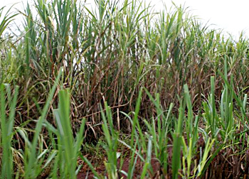
Of the total area of the district, 214.23 hectares is the net sown area. The Sahyadri Ranges, part of the Western Ghats mountain range, feeds the rivers round the year and inundates the fertile alluvial soil. The main crops grown in the Shimoga district are paddy, coconut, ragi, pepper, areca and sugarcane. Others include maize, oilseeds, fruits, cotton, cashew nut, chillies and ginger. The net irrigated area is127.70 hectares. The Sharavathi Hydel Project and Varahi Project provide a substantial portion of the state`s power needs. Among the major minerals found here are Limestone, White Quartz, Manganese, Kaolin and Kainite.
Education In Shimoga District
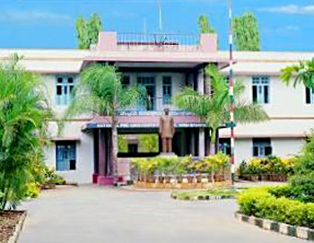 Education in Shimoga district is in quite a developed state. There are many educational institutions found here that cater to the various educational needs of the district. Each habitation with a population of 200 or more has a primary school. There are Higher Primary Schools, High Schools and Junior Colleges which are easily accessible to rural areas also. Each Taluk Headquarter has a Degree College. For the purposes of Higher Education, there is found an Engineering College, a Dental College as well as a Polytechnic. Higher education is also accessible from the rural areas. A University centre is also found located here in the Shimoga district.
There are 1106 Lower Primary Schools and 1185 Higher Primary Schools in the District of which 998 Government Lower Primary Schools and 940 Government Higher Primary Schools. Only 3 Aided Lower Primary Schools and 53 Aided Higher Primary Schools are there in the District. 90 percent of the Lower Primary Schools are Government Schools. Only 0.3 percent is Aided Lower Primary Schools and 9.7 percent are Unaided Lower Primary Schools. Among Higher Primary Schools, 79 percent are Government Schools, 4.47 percent are Aided Higher Primary Schools and 16.53 percent are Unaided Higher Primary Schools. The Government has opened many schools in the District and extended support for private managements to run Primary Schools.
Among the major universities found in the district are the Kuvempu University, the Post-Graduate centre at Davanagere and the post-Graduate Centre at Kadur. Kuvempu University is a young affiliating University in Karnataka. Established in 1987, it is a University with a distinctive academic profile, offering 45 Post-Graduate Programmes, 4 P.G. Diploma and one under-Graduate programme. The University has 184 affiliated colleges, five constituent colleges, five B.P.Ed colleges, six Law colleges and 43 B.Ed. colleges under its jurisdiction spread over 4 districts of Shimoga, Chitradurga district, Chikmagalur district and Davanagere district. It also has outlying regional Post-Graduate centres at Davanagere and Kadur. The Post-Graduate departments of studies in Commerce, Economics, Biochemistry, Microbiology, Food and Nurtrition Technology and Master of Social Work are located at Shivagangothri campus of Post-Graduate centre at Davangere. The Institute of Management Studies is located in a new building at Shivagangothri. A new post graduate centre has been opened at Kadur from 2007-08, starting with three initial courses of Master of Business Economics(MBE), Master of Business Administration(MBA) and M.Sc. Pharmaceutical Chemistry.
Among the constituent colleges of the Kuvempu university are the Sahyadri Arts and Commerce College, Shimoga Sahyadri Arts and Science Colleges and Sahyadri Science College, erstwhile Government institutions. These premiere Colleges of this region have completed 66 years of existence. Other Colleges in the district are the University B.D.T. College of Engineering at Davanagere, University Fine Arts College at Davanagere and the Jawaharlal Nehru National College of Engineering (JNNCE).
Economy of Shimoga District
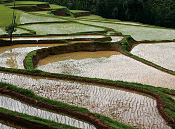 Economy of Shimoga district is mostly dependant on agriculture. Agriculture, including animal husbandry, has been the major contributing sector in the income of the district. The Sahyadri ranges, part of the Western Ghats mountain range, feed the rivers round the year, and inundate the fertile alluvial soil. This makes Shimoga district the bread basket of Karnataka. Shimoga district happens to be granary of paddy in Karnataka, and it is also known as the `rice bowl` of the state. Of the total area of the district, 214.23 hectares is the net sown area. The major crops grown here are paddy, coconut, ragi, pepper, areca, sugarcane, maize, oilseeds, fruits, cotton, cashewnut, chillies and ginger. The net irrigated area is127.70 hectares.
The industrial scenario in Shimoga district is also quite impressive. On an average, the district has over 9500 units, with an investment of approximately Rupees 12000 lakhs. The industries here employ 41000 persons. The most prominent units in the district are the agro-based industries, automobile-based industries and the engineering-based industries. The average investment per unit is about 1.30 lakhs and the employment per unit on an average is 4 persons. So far, the maximum amount of investment has been made under the food and beverages sector followed by the general engineering/mechanical products. Likewise, in the sectors, Food and Beverages and General Engineering or mechanical sector like the employment provided is the maximum.
The foundry units in the district have been very successful in producing quality products. They have been manufacturing components for automobile sector, electric motors etc. Some of them have been exporting their products that have obtained ISO certification. Under the rural artisans category, there are units like traditional carpentry, blacksmith, leather crafts, pottery, beekeeping, stone cutting, handlooms, agarbatti and sandal carving etc. There are about 13000 artisans spread over the entire district under various crafts. Among these, sandalwood articles have brought number of awards to the district. These products have been displayed in various trade fairs and exhibitions. Some articles are being exported through KSHDC. There are a total of three hydroelectric power projects existing in the state.
Consistent efforts have been made by the state in order to develop and promote the economic development of the state. The Regional Design and Technical Development Centre, Govt. of India has been imparting training in lacquer-ware at Kugve, Sagar taluk. RUPREG (Rural Self Employment Promotion Research Guidance Centre) is a specialised training centre promoted by Canara Bank in association with Department of Industries and Commerce, Government of Karnataka to train the rural youth in tailoring, embroidery, motor winding, hand pump repair and also conducting EDPs. Skill-oriented training in carpentry, leather stitching, cane and bamboo and sandalwood carving is provided at ATI, Sagar. Handicraft artisans producing sandalwood and rosewood articles are producing certain precious articles, which have great demand in the country as well as abroad.
Administration of Shimoga District
Administration of Shimoga district is headed by the Deputy Commissioner of the district. There are various officials both at the district level and at the taluk level to assist the Deputy Commissioner in the task of administration. They include the Assistant Commissioners (Sub Divisional Magistrate), Tahsildars, Shirstedars, Revenue Inspectors and Village Accountants. The Collectorate consists of various branches headed by the Srishtedars who are responsible for the supervision, guidance and overall management of work in their branch. Every branch consists of First Division Assistants and Second Division Assistants among whom all work of the branch is divided.
The Deputy Commissioner Court deals with cases pertaining to Revenue Appeals, Revenue Miscellaneous ( KLR Act, 1964 ), Prohibition of transfer of Certain Lands cases ( PTCL Act,1978 ) and inam cases( Inam Abolition Act ). One SDA and Manager of Judicial Branch assist the D.C by doing back office work. The Office of the Deputy Commissioner deals with a variety of functions.
These different function areas are broadly divided into the following categories.
Administrative Section: it deals with all the matters relating to vacancies, appointments, pay and allowances, transfers and promotions, postings, retirements, personal deposit accounts, audit reports, DC diary and statistics.
Revenue Section: This section deals with jamabandi, DCB (Demand Collection and Balance), Land Grants, Land Acquisition, Land Conversion, PTCL, Appeals, Land Reforms cases, Mines and Minerals and Regularisation of encroachments.
Election Section: This section deals with election matters pertaining to Loksabha, Vidhansabha, Vidhanparishat, all local body elections such as Grama Panchayat, Taluk Panchayat, Zilla Panchayat, Municipalities, APMC, and other co-operative institutions.
Municipal Section: This section deals with all municipal matters including service matters, progress made under various schemes like SJSRY (Swarna Jananthi Shahari Rozgar Yojana), IDSMT (Integrated Development of Small & Medium towns), Water supply schemes, Housing schemes and Slum Area Development.
Muzarai Section: This section deals with construction & renovation of Muzarai temples, appointment of Dharmadarshies and payments to Archaks` (Tasdik and annuity) salary, Aradhana Schemes.
Census Section: This section deals with census matters.
Judicial Section: This section deals with judicial matters such as Law and Order (Section 144 etc.,) issue of licenses for Arms and Ammunitions and Cinemas.
Miscellaneous Section: This section deals with NSAP, OAP, PHP, MPLAD and other Schemes. It also deals with meeting statistics, PWD works, issue of income and caste certificates, House Rent Control (HRC) and other miscellaneous matters of Revenue Department.
The Shimoga Zilla Panchayat is a body that has been constituted under the Karnataka Panchayat Raj Act, 1993. The Panchayat Raj Act provides for a 3- tier structure of Panchayats. The Zilla Panchayat forms the apex institution at the district level. Each of the seven taluks in the Shimoga district has the Taluk Panchayat, where again the members are directly elected from the people, and which has a similar administrative structure headed by the Executive Officer (EO). At the lowest level there are the Gram Panchayats which are having jurisdiction over a group of villages so notified. The Zilla Panchayat is a body corporate that has been given a legal status. The prime role of the Zilla Panchayat in the task of administration is to deal with the execution of development schemes, providing civic functions in rural areas and looking after the duties of the government delegated in respect of certain departments as per the schedule of the Act. The Chief Executive Officer is appointed by the state government to carry out the administration of the Zilla Panchayat. He is the head of department of the various departments that have been established within the Zilla panchayat. The Chief Executive Officer is assisted in the discharge of his duties by senior officers in the Zilla panchayat. They include the Deputy Secretary (Development), Deputy Secretary (Administration), Chief Accounts Officer, Chief Planning Officer, Project Director.
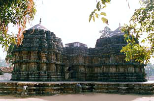
Temples of Shimoga District
 The temples of Shimoga district in Karnataka are famous in south India for their traditional style of architecture. Shimoga District is located centrally in Karnataka. `Shimoga` means `face of Shiva` and most of the temples of Shimoga district are dedicated to Lord Shiva. The district is blessed with nature`s bounty, landscapes dotted with waterfalls, swaying palms, and lush paddy fields.
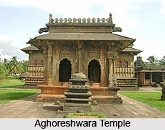
Major rivers such as Tunga, Bhadra, and Varada run through Shimoga thus making it a sacred land. Apart from the popular temples of Shimoga district, the tourist attractions are Jog Falls, Vanake-Abbey Falls, Achakanya Falls, Hidlamane Falls, Tunga Dam, B R P Dam, Kodachadri and many other spots. Aghoreshwara Temple is one of the most famous temples of Shimoga district. This is a symmetrical temple without any complicated decoration. This temple in Ikkeri is located in a field at a distance of 3 km from Sagar town. The presiding shrine deifies Lord Shiva. There is also an Amman shrine and a beautiful Nandi shrine inside the sanctum. The temple architecture is a blend of Hoysala and Dravida style. The entire temple along with Mukha mandapa and shrine is constructed of hard black basalt stone. The six-pillared mandapa, the entrance to the shrine is of the Vijayanagar style, and the sculptures on the outside entrance belong to the Hoysala style.
Rameshwara Temple is located at Keladi in Shimoga District of Karnataka. It is one of the well-known temples of Shimoga district that was built by Chaudappa Nayaka, the founder of the Keladi kingdom. Traits of Hoysala and Dravidian style of architecture can be witnessed in the construction of the temple. Veerbhadreshvara temple and Parvati temple are the two important temples of Shimoga district that stands in the vicinity of this shrine. Keladi Museum is also a tourist spot located nearby. Sangameshwar Temple is an ancient temple sited at Koodali, about 17 km from Shimoga. The place is also distinguished as the merging point of Tunga River and Bhadra River. Dedicated to Lord Shiva, the temple enshrines the idol of Lord Narasimha (Chintamani Narasimha) that was installed by the legendary character Prahlad. This temple is popularly known as Narasimha Kshetra. Apart from the presiding deity, the temple also houses the images of Sri Brahmeshwar, Shankaracharya, Devi Sharada and Goddess Parvati. Harihar Temple is the nearby attraction.
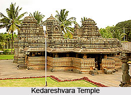
Rameshwara Temple is located on the banks of Tunga River and is one of the major temples of Shimoga district, sited at Thrithahalli. According to myths, Sage Parashuram installed the idol or the lingam of Lord Rameshwara in this temple. He worshipped this idol to remove the curse of having killed his mother. Associated with the Pandavas, the temple houses the idols of Lord Ram, Lakshman and Devi Sita. Another attraction is the image of Lord Narasimha. Bheemannaghatta Mutt, an ancient Madhwa mutt, is the nearby attraction. Some other temples of Shimoga district are Aghoreshwara Temple, Rameshwar Temple ,Sangameshwar Temple, Kedareswara Temple and Rameshwara Temple.
Harihar: The 12th century temple of Lord Harihar, built by Hoysala king Vishnuvardhana, is worth visiting. In the sanctum, the huge image of the Lord is flanked by Parvati and Lakshmi. Nandi and Garuda are facing the sanctum. The star-shaped front mandapam is known for intricate carvings.
Kalasa: The Shiva temple here on the banks of Bhadra river is dedicated to Kalaseswar. This Swayambu Lingam is believed to have sprouted from the Kalasam of sage Agastya. Hence the Lord`s name. The Lingam is enshrined in a silver mandapam in the sanctum. The beautiful image of Goddess Parvati is known as Sarvaangasundari.
Lord Visweswara is enshrined on the outer prakaram. This place is revered as Dakshina Kashi.
Oranadu Annapoorneshwari: The temple is situated in beautiful surroundings. Sage Agastya is said to have installed the deity. The sanctum was renovated in recent years by a learned astrologer, Venkitasubba Jois. It has been designed in a unique manner. The single image depicts the Devi standing on a peetam with Devi Gayatri, Sri Chakram, Shanku and Chakra in Her 4 hands. The sanctum is surrounded by Adi Sesha and the Padma Peetam is formed by Ashtagaja, Koorma and others.
Koodali : It is a renowned pilgrim spot where the rivers Tunga and Bhadra meet. Though a small village, a lot of Puranic importance is attached to this place.
 A Lingam, known as Sangameshwar, is installed on the riverside. There are shrines dedicated to Narasimha, Rameshwar, Devi Sharada and Brahmeshwar. This place is around 17 km away from Shimoga.
The place is known as Narasimha Kshetra because of the presence of Lord Narasimha here. Prahlada is believed to have installed the deity of Saligrama image. He is known as Chintamani Narasimha.
Brahma installed the image of Sri Brahmeshwar with Devi Parvati. Sri Adi Sankara installed Devi Sharada`s image on the river bank. There are shrines for Adi Sankara and Devi Sharada. There are several Brindavanams of Madhwa swamijis on the banks of the river.
Thirthahalli : Here is a shrine of Rameshwar, located 52 kilometers from Shimoga, on the banks of Tunga river. Sage Parasurama is believed to have installed the Lingam and done penance to redeem himself from the curse of having killed his mother.
Amirtha Theertham : This is the birthplace of River Sharavati. A Lingam is installed at this sacred spot.
The place is associated with Pancha Pandava. Situated about 7 km away is Bheemannaghatta Matha, an ancient matha belonging to Madhwa swamijis. It houses the deities of Rama, Lakshmana, Sita and others worshipped by Bheemasena and an image of Narasimhamurthy worshipped by sage Durvasa.
Tourism in Shimoga District
 Tourism in Shimoga district in Karnataka is an appreciation of the natural beauty of the place. There are a number of waterfalls and beautifully constructed dams that are visited by a number of tourists from various parts of the country. Shimoga district is also home to various religious centers and sanctuaries. Some of the popular tourist destinations in the district are as follows-
Waterfalls in Shimoga District
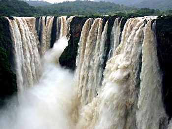
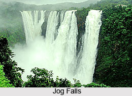
By far the most attractive tourist destination in the Shimoga district is that of the Jog Falls. The world-famous Jog Falls is situated on the borders of Shimoga and North Kanadda, about a 100 kilometres away from Shimoga district. The sight of the river Sharavathi taking a spectacular leap into the chasm from a height of 900 feet is most remarkable.
The river Sharavathi hurtles in four distinct cascades. The first of these falls is known as the `Raja` - the grandest, an unbroken sheet of water, the Raja plunges into the vapour- shrouded poll 900 feet below. A few 100 feet way down, with a thunderous gush, Raja is joined by `Roarer`. Leaping down with great speed in a series of cascades is the `Rocket`. And gliding away with feminine grace is `Rani`. The effect is greatly heightened by the wild and beautiful region around which is covered with a wealth of luxuriant vegetation. The steps cut into the rocks leads one to the very depths of the fall. The place is well connected with Shimoga city by road as well as rail. There are a number of Government and private buses that ply between Shimoga and the Jog falls. The best time to visit the place is between July-January.

There are a number of other beautiful waterfalls located here as well. Situated four kms away from Agumbe are the Abbey Falls. The falls are surrounded by lush green trees and natural beauty. 10 Kms from Thirthahalli on the way to Hosanagar near Aralsuruli the eye-catching Achakanya falls. The Sharavathi River takes a spectacular leap here to form this wonderful falls. The Hidlamane falls is situated near Nittur in Hosanagar taluka. To reach the falls, one has to trek the rocky hills surrounded by dense lush trees.
Dams in Shimoga District
Apart from the many waterfalls located here, there are also a number of beautiful dams that are quite popular amongst the tourists. The Tunga Anecut is located 10 Kms from Shimoga city on the way to Thirthahalli at Gajanur. The Tunga Dam is situated here. It is a popular picnic spot. The B.R.P. Dam is located 28 Kms from Shimoga city near Kuvempu University. The dam has been constructed over the Bhadra River at a height of 194 feet. There are a number of islands found here that have been created by the Bhadra river, and one can enjoy a boat ride around these islands. The Linganmakki Dam is situated 6 Kms away from the Jog Falls, across the river Sharavathi. The height of the dam is 1819 ft above sea level. Linganmakki dam is the main feeder reservoir for the Mahatma Gandhi Hydro Electric Power unit.
Religious Spots in Shimoga District
Shimoga district is home to a number of temples that are equally frequented by the tourists. Humcha also called "Hombucha" is a famous Jain pilgrim centre in Shimoga District. It was founded in the 7th century by Jinadattacharya, founder of the Santhara dynasty. Chowdeshwari Temple is another holy center located in the other side of backwater of river Sharavathi (before Jog falls). The Lakshmi Narasimha Temple, built by the Hoysalas, is also a notable pilgrimage center in the district.
 Some of the other religious destinations in Shimoga district include Sarvajna Peeth, Kedareswara Temple, Rameshwar Temple, Tripurantaka Temple, Sri Rameshwara Temple, Sri Ranganatha Temple, and Siddi Vinayaka Temple.
Wildlife Sanctuaries in Shimoga District
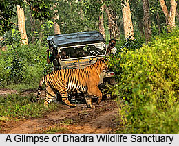
Tourists visiting this picturesque district can also have a look on the varied wildlife sanctuaries. Sharavathi Wildlife Sanctuary, situated in Sagar of Shimoga District, is spread over an area of 431 kms and is home to a variety of mammals, birds, reptiles and the endangered Lion-tailed macaque. Bhadra Wildlife Sanctuary is situated in the midst of Western Ghats in Chikmagalur and Shimoga districts of Karnataka and boasts of a substantial tiger population. Then there are Gudavi Bird Sanctuary and Mandagadde Bird Sanctuary in Shimoga District. Both the bird sanctuaries are home to an impressive number of bird populations.
Shimoga : Shimoga is a city of Chikmagalur district of Karnataka state. It is the head quarters of the district known by the same name. The district spreads covers an area of 8,465 sq. km. and the population as per the 2001 Census is 14, 52,259. The city is 274 km from the state capital Bangalore. It is situated on the banks of the sacred river Tungabhadra. During the days of Keladi Nayakas, Shimoga was very popular.
 Shimoga has very interesting landscape interspersed with historic monuments. There is a temple at Badravathi in Shimoga. The presiding deity of this temple is the Lord Lakshminarayana. It was constructed following the Hoysala architecture. There are also large numbers of industries in the Shimoga city. This city is well known for its ivory and sandalwood industries. These articles of the city attract lots of tourists. The visitors can enter the factories filled with the exotic sandalwood fragrance and those suffused with the coveted ivory.
Shimoga attracts lots of visitors with diverse interests, with its architectural temples and wonderful industries. It is also an enchanting picnic spot. The Jog Falls here stands out as the highest waterfalls of the Nation. The Mahatma Gandhi Hydro-Electric Power Station is also a worth visiting place here.
Government District Museum at Shimoga
Shimoga also houses an archaeological museum. The Government of India built it in the year 1950 in order to store the excavated materials and the objects of archaeology.
As a result of this, presently it is a show house of sculptures, inscriptions, paintings, arms, coins, paper manuscripts, palm leaf manuscripts, woodcarvings and copper plates. People are welcome in the museum from 9am to 5pm except on Mondays and Government Holidays.
How to Reach Shimoga District
Shimoga is well connected by road and rail to the major cities of Karnataka and neighbouring states. One can travel either by air or surface. By Air, the nearest point would be Mangalore Airport. From here on one will have to travel by road to reach Shimoga. There is also a way to reach Shimoga by rail route from Bengaluru, Mysore and Hubli.
By Air- Mangalore Airport is the nearest Airport - 200 Kms
By Rail- Shimoga is connected by Rail to Bengaluru, Mysore and Hubli
By Road- Shimoga city is well connected by road to all major cities, towns and important cities of neighbouring states.
By Air- Mangalore Airport is the nearest Airport - 200 Kms
By Rail- Shimoga is connected by Rail to Bengaluru, Mysore and Hubli
By Road- Shimoga city is well connected by road to all major cities, towns and important cities of neighbouring states.
Recently updated articles in States of India

History of Thissur District
Early History of Thissur District explains flourishing of the port cities. Now these port cities are transformed into archaeological sites.

Tippi Orchid Research Centre, Arunachal Pradesh
Tippi Orchid Research Centre in Arunachal Pradesh is renowned for its rich collection of exotic and endangered orchids. Surrounded by lush rainforest...

Tourism in Nashik District
Pilgrimage tourism in Nashik district involves visiting the various places of Hindu and Jain worship located here. Some of the holiest sites for Hind...

Mangadu, Kerala
Mangadu in Kerala’s Kollam district is a significant megalithic site known for its urn burials, cist burials, menhirs, and stone circles. Excavations...

Devaswom
History of Devaswom is not very ancient and can be dated back to late seventeenth century.
Related articles in States of India

East Indian States
East Indian States comprises of Bihar, Jharkhand, West Bengal, Odisha and also the Union Territory of Andaman and Nicobar Islands. It defines the cult...

Purnia District in Bihar
Purnia District is located in Bihar and extends from River Ganga to Nepal. The district has a rich Hindu history and glorious past.

Hooghly district
Hooghly District along the bank of the river Hooghly is one of the principal trading ports of West Bengal.

Geography Of Chittoor District
Geography of Chittoor district is spread along the topography of the land which is divided into two natural divisions; Chittoor has a dry and healthy...

Districts of West Bihar
Districts of West Bihar is comprised of medieval monuments that were built by the different governors of Mughal era.