 Physiography of Southern regions consist of the physical features of the various kinds of landforms in the Southern Indian states like Andhra Pradesh, Tamil Nadu, Karnataka and Kerala.
Physiography of Andhra Pradesh
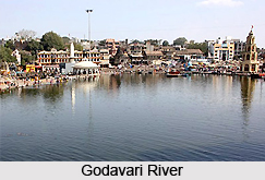
Three physiographic regions mark the state of Andhra Pradesh: the plateau situated at the western part of the Eastern Ghats, Eastern Ghats and the coastal plain which extends from the area near the Bay of Bengal. The Central portion of the plains is made of the deltas made by Krishna River and Godavari River. The Eastern Ghats continue from the central region of India to the south and run parallel to the eastern coast.
Part of the Deccan Plateau is made up of gneissic rock and has a height of around 1600 feet or 500 metres. The northern part of the plateau is termed as Telangana and the southern part is referred to as `Rayasaleema`. Black soil is existent in some regions of this place.
Summers last from March till June while tropical rainy season is form October to February. In Andhra Pradesh, the maximum temperature recorded is about the low 80s Fahrenheit and the minimum temperature recorded is around the low 50s Fahrenheit. Some of the areas in the coast might get only 1400 mm of rainfall.
Physiography of Tamil Nadu
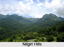
Tamil Nadu can be divided into five broad divisions, namely the Kurinji area, Mullai or the regions covered by forests, the Palai area, the Marudham or the area represented by fertile plains and the coastal regions or the Neidhal. Tamil Nadu forms the intersection point of the Western Ghats and Eastern Ghats. Hills stations located in this Indian state, which consist of Yercaud, Kodaikanal, Kothagiri and Udhagamandalam are important places which are worth mentioning. Shencottah gap and Palakkad gap interfere with the ranges of these hills. Pollachi Valley and Cumbum Valley comprise of plantations of spices, coffee and tea.
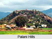 Palni Hills are rich in forests which contain medicinal herbs. River Kaveri is the perennial river of Tamil Nadu. Palmyra trees are found in Tirunelveli and all its products are utilized as raw materials for cottage industries. In Kannyakumari, rubber is the main crop which is grown in large numbers. River Cauvery irrigates the Coromandel Plains, alongwith its delta in the area of Thanjavur - Nagapattinam, which is referred to as Tamil Nadu`s granary. Tamiraparani, Palar, Vaigai and Pennar are the different rivers of Tamil Nadu. The Palai region or the district of Tirunelveli is the only place in the state which contains arid land.
Monsoon rains bring relief to the state of Tamil Nadu and the absence of rains result in severe droughts in India. The climate of this state is semi-dry and semi-humid. The South West monsoons, which continue from June till September, the North-East monsoons which start in October and last till December and the dry region last till May, starting from January. Tamil Nadu`s annual rainfall is about 945 mm.
Physiography of Karnataka
The geographical coordinates of Karnataka are 12.970214 north latitude and 77.56029 east longitude and the total area of Karnataka is 1, 91, 791 square kilometre. Karnataka comprises Deccan Plateau, Islands and Coastal Plains. The four different physiographic landforms of this state are:
Northern Karnataka Plateau
This part of Karnataka consists of districts like Bidar, Belgaum, Gulbarga and Bijapur. The area of Deccan Trap is an essential portion of Karnataka and constitutes a large, deforested plateau which has an elevation measuring about 300 metres to 600 metres from the sea level. River plains are also present and are represented by those of River Malaprabha, River Ghataprabha, River Bhima and River Krishna. These are accompanied by watersheds, regional hills and ridges. Black cotton soils cover this region.
 Central Karnataka Plateau
The districts of Chikmagalur, Shimoga, Dharwar, Raichur, Bellary and Chitradurga are covered by the Central Karnataka Plateau. This place is located between The Southern Karnataka Plateau and the Northern Karnataka Plateau. This is the exact location of the basin of Tungabhadra River. The elevation of this place is around 450 to 700 metres and this region is found to slope towards the east.
Southern Karnataka Plateau
The districts of Karnataka, namely Tumkur, Mysore, Bangalore, Mandya, Bangalore Rural, Kolar, Kodagu and Hassan are included under the Southern Karnataka Plateau. The Cauvery River basin also forms a significant part of this place. The Western Ghats enclose this area I the southern and western part. The elevation measures around 600 to 900 metres.
Karnataka Coastal Region
The Karnataka coastal belt extends from the Western Ghats in the west and continues till the Karnataka Plateau in the east, covering the districts of Uttara Kannada and Dakshina Kannada. Terrains consisting of ranges of hills, peaks, waterfalls, creeks and rivers. This area has two main geographical divisions, known as Western Ghats and the plains. The southern parts of the Ghats measure about 900 to 1, 500 metres while the northern part of the Ghats measure about 450 metres to 600 metres.
The climate of Karnataka is equitable, especially in the regions which possess high plateau. This state receives a moderate quantity of rainfall during winter as well as summer, thereby keeping it cool throughout the year. However, the climate alters between the various places of Karnataka. For instance, the average rainfall in areas of Kanara coast is about 762 centimetres and the rainfall in Western Ghats is 254 centimetres.
 Physiography of Kerala
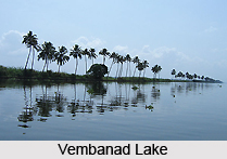
Three regions demarcate the physiography of the state of Kerala, namely the Highlands, Midlands and Low Lands. Plantations like cardamom, tea, coffee and rubber are grown in the region of the Highlands. The Highlands slope downwards from the Western Ghats and their height measures 900m. The area of Midlands which is placed between the hills and lowlands consist of undulating hills. Sugarcane, banana, cashew nuts, coconuts and many types of vegetables are cultivated on a large scale in this place. There are 41 west-flowing rivers and three east-flowing rivers in the state. A series of backwaters and tributaries intersperse the rivers. They are all monsoon-fed. There are several ocean inlets and lakes formed in Kerala. Some of these lakes are Vembanad Lake, Nadayaram Paravoor, Kayamkulam, AnjuThengu, Kodungallor, Cheruva and many others.
The state of Kerala is characterised by a tropical as well as an equitable climate. Therefore Kerala`s climate is quite pleasant the entire year. During the months of December to January, the winter season dominates the state and summers are in the months of April to May. During summer, temperatures shoot up to 33 degree Celsius. In monsoons, the majority of rainfall is experienced in Peerumedu in Idukki and Vaithiri-Kuttiyadi range in Malabar. October marks the commencement of the north-east monsoons. Tourists enjoy the winter season here, particularly from November to February.
Physiography of the southern of India is varied, and comprises the distribution of annual rainfall, climate and physical topography.


