Imtroduction
 Dakshina Kannada District is a coastal Karnataka district in the state of Karnataka. As boundaries, it has the Udupi District to the north, the Chikmagalur District to the northeast, the Hassan District to the east, the Kodagu District to the southeast, and the Kasaragod District in Kerala to the south. The Arabian Sea bounds it on the west. Mangalore is the administrative headquarters of the district. Significant towns in the district are Mangalore, Munnur, Surathkal Adyar, Bajala, Belthangadi, Kannur, Kotekara, Mulur, Mudushedde, Mulki, Pudu, Puttur, Someshwar, Sullia, Thumbe, Kokradi and Ullal.
History of Dakshina Kannada District
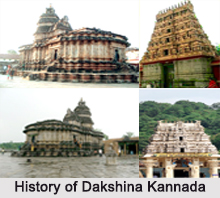
Before 1860, Dakshina Kannada was part of a greater district called Canara, which was under the administration of the Madras Presidency. In 1860, the British split the area into South Canara and North Canara, the former being retained in the Madras Presidency, while the later was made a part of Bombay Province in 1862. After Indian independence in 1947, South Canara was divided into Dakshina Kannada and Udupi districts. The then undivided Dakshina Kannada district consists of the present day borders of Dakshina Kannada, Udupi and Kasaragod. Later in the year 1997, the Karnataka Government, for facilitating administration, split the greater Dakshina Kannada district into Udupi and the present day Dakshina Kannada districts in the year. The district is famous for red clay roof tiles, cashew nuts and unusual cuisine.
Tulu language is the main dialect of the Dakshina Kannada district. Kannada, Havyaka Kannada, Kundapura kannada, and Konkani are also spoken by a substantial. English language and Kannada being the administrative languages are understood by majority of the population.
Tulu language is the main dialect of the Dakshina Kannada district. Kannada, Havyaka Kannada, Kundapura kannada, and Konkani are also spoken by a substantial. English language and Kannada being the administrative languages are understood by majority of the population.
Demography of Dakshina Kannada District
According to the Population Census in the year 2011, Dakshina Kannada District had population of 2,083,625 of which male and female were 1,032,577 and 1,051,048 respectively. The population of Dakshina Kannada District constituted 3.41 percent of total population of Karnataka. The population density of Dakshina Kannada district for 2011 is 457 people per sq. km. The average literacy rate of Dakshina Kannada in 2011 was 88.62 compared to 83.35 of 2001. If things are looked out at gender wise, male and female literacy were 93.31 and 84.04 respectively. The total literates in Dakshina Kannada District were 1,666,834 of which male and female were 866,331 and 800,503 respectively.
Education of Dakshina Kannada District
The Dakshina Kannada district has made substantial progress in academics. Primary and secondary education has reached every segment of society. The district`s literacy rate is considerably above the national average. A large number of educational establishments offering courses in Medicine, Engineering, Pharmacy, Nursing, Hotel and catering and Management are located in this district
Culture of Dakshina Kannada District
Dakshina Kannada District is a land of culture, tradition and rituals. The district has many temples of Hindu gods and goddess, which lend an aura of spiritualism to the place. The people of Dakshina Kannada worship the serpent god (Lord Subramanya). As a legend goes, Parashurama from sea reclaimed the district. Many native rituals like nagaradhane and Bhuta Kola are performed here. Kambla is a form of buffalo race organized on the muddy track in the paddy field. Moreover, cockfights are also held.
Jain temples at Dakshina Kannada District
 Dakshina Kannada is a coastal Karnataka district in the state of Karnataka in India. The Udupi District lies to the north, the Chikmagalur District to the northeast, the Hassan District to the east, the Kodagu District to the southeast, and the Kasaragod District in Kerala to the south. The Arabian Sea bounds it on the west. Mangalore is the administrative headquarters of the district. There are many Jain temples located here that attracts pilgrims from different places.
Moodabidiri
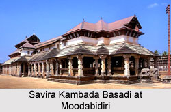
It is a small town that is located almost 35 km northeast of Mangalore. There are few pilgrimage centers located here that are of much importance to the Jains. There are eighteen Bastis located here out of which "Tribhuvana Tilaka Chudamani Chatyalaya is the biggest. This magnificent monument is magnificently designed. The monument is adorned with about thousand pillars that give support to it. The monument is thus popularly known as "Savira Kambada Basadi." This beautifully carved monument was built in 1431 by eight traders and four town councilors. Later the queen of Garesappa, Bhairadevi, constructed a mandapa to the Basti in the year 1402. Queen Nagala Devi installed fifty feet high Manastambha in front of the monument. The intricately designed pillars the major attraction of this Basti. The architectural beauty has made this place a popular tourist spot. The monument is also adorned with elaborately carved figures of drummers, elephant riders, chauri-bearers, a giraffe and a dragon.
The small town of Moodabidiri also houses a Jain Math that holds a prominent place among the Jains. The math like other Jain temples has been artistically designed. Its walls have been adorned with beautiful ancient paintings. One of the paintings depicts the male headgear that belonged to that period. Apart from these the math also portrays fine miniature paintings of Jain Tirthankaras, Yakshas and Yakshanis (celestial bodies). It also has paintings of many kings, queens, devotees as well as ornamental flowers. These paintings have been brilliantly painted with bright colors. However, most of these painting have faded now. Here is a rare treasure house of painted palm leaf manuscripts Dhavala, Jayadhavala and Mahadhavala, which dates back to 1114 AD.
Karkala
Karkala is a small town located 52 km to the northeast of Mangalore. The statue of Gommteshwera was installed here in the year 1432 AD by Vir Pandya of the Santara family. It is almost 42 feet monolithic statue. The statue is positioned on a rocky hillock. Later in the year 1437 AD a Brahmadeva Stambha was set up in front of Gommata. The sculpture of Lord Brahma that is located on the top of the pillar reflects the magnificent art work.
The Neminatha Basadi was constructed at Hiriyangdi in the year 1329 AD. Another 54 feet manasthambha had been installed in front of the Basadi. This beautiful image has been made of single rock.
In the year 1586 AD the Chaturmukha Basadi of Karkala was completed. The Basadi has four identical entrances in four different directions. The garbhagriha houses statues of Ara, Malli, and Suyrata. The images of 24 Jain Tirthakaras, Yakshi Padmavati can also be seen here.
Venur
It is situated almost 15 km from Dharmasthala. The town houses a beautiful statue of Gommata that was erected by Timmanna Ajila. The statue was built in 1604 AD and is 38 feet tall. There are eight Basadis located here. Among them the Shantinatha Basadi is the most popular among tourists for its architectural splendor.
Dharmasthala
Dharmasthala is located 75 km from Mangalore. The town is situated on the banks of the Netravati River. The town holds great religious significance for the Jains. Here the Jain Tithankaras are placed on the same ground with Lord Manjunatha or Lord Shiva. They are even worshipped together. This town is known for religious tolerance. The priests who worship the images are Vaishnavites but the hereditary guardians are Jains by faith. In the year 1973 an idol of Gomata was established here by the Trustee Veerendra Heggade. The idol is almost 52 feet in height and weighs about 175 tons. It is regarded as the third largest statue in the country.
Tourism In Dakshin Kannada District
 Dakshina Kannada District is a district of the Indian state of Karnataka. It lies in the southern part of the state. The habitants here are `Tulu language` speakers and hence it is also known as `Land of Tuluvas`. This district has lots of beautiful tourist places. Some of them are given here:
Mangalore in Dakshina Kannada District
Mangalore is now the headquarters of the Dakshina Kannada district. It was earlier known as Mangalapura. It was in the past the long time capital of the kings known as Alupas. This is a port city situated at the confluence of the beautiful Netravati River and Gurupura River. It was also the headquarters of Canara under the British in the 18th century. Mangalore is a beautiful palm fringed west coast city. It is accessible from Madikeri, the headquarters of Coorg district by a road filled with wonderful sceneries. With its lagoon, enchanting palm grooves and interesting landscape, Mangalore has a typical coastal climate. A number of ancient temples, churches and mosques can be seen here. The city consists of a number of places of tourists` interests with good accommodation facilities.
Mangaladevi Temple in Dakshina Kannada District
This beautiful temple is situated about 3 km from Mangalore. Goddess Mangaladevi is the presiding deity of this temple. The city owes the origin of its name to this deity. This temple was built in the 10th century.
Ullal in Dakshina Kannada District
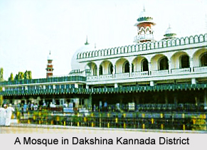
The enchanting beach marked by abundant fir trees makes this place one of the tourists` attraction in Dakshina Kannada. The Sayed Mohammed Shenphul Madani Mosque sanctifies this place. It is pilgrim spot as well as a good picnic spot. It is situated 12 km from Mangalore.
 Karkala in Dakshina Kannada District
It is situated about 50 km from Mangalore. This place is a sacred worship centre of the Jains. It was the seat of the Bhairasas or Shantarsas, the royal Jain dynasty. Two huge statues of `Sri Gomatheshwara` or Bahubali can be seen here. One measure 13 meter in height and the other is of 11 m. There are four entrances to the shrine here and is known as `Chathurmuka Basti`. The other important monuments here include temples and bastis and St. Lawrence church. The Ananthasayana temple and Venkataramana Temple dedicated to Lord Vishnu also attract a large number of devotees.
Karkala in Dakshina Kannada District
It is situated about 50 km from Mangalore. This place is a sacred worship centre of the Jains. It was the seat of the Bhairasas or Shantarsas, the royal Jain dynasty. Two huge statues of `Sri Gomatheshwara` or Bahubali can be seen here. One measure 13 meter in height and the other is of 11 m. There are four entrances to the shrine here and is known as `Chathurmuka Basti`. The other important monuments here include temples and bastis and St. Lawrence church. The Ananthasayana temple and Venkataramana Temple dedicated to Lord Vishnu also attract a large number of devotees.
Udupi in Dakshina Kannada District
Udupi is a place in Dakshina Kannada district of Karnataka state. It is situated about 58 km from Mangalore. Udupi is on a national highway and has easy road access from Mangalore and Karkala which is just 32 km away.
The famous ancient temple dedicated to Lord Sri Gopalakrishna is found here in Udupi. Sri Madhvacharya who propounded the Dvaita philosophy was the founder of the temple. The icon of the acharya can also be seen in this temple.
There is a fine beach resort in the Maple port near Manipal in Udupi. The Vadabhandeswara Temple dedicated to Lord Balarama is very famous here in Udupi. Manipal is also noted as an important centre of education. The cuisines of Udupi and the wonderful coastal town are popular among the tourists. The lip smacking delicacies of the Udupi cuisines are much sought-after. The city offers good accommodation facilities.
Agumbe in Dakshina Kannada District
It is situated about 50 km from Udupi. This is an ideal spot for sunset watchers. The best season here to have a glorious view of the red sun disappearing in the west is between November and December.
Dharmasthala in Dakshina Kannada District
It is situated about 75 km from Mangalore. It is a beautiful sacred island formed by the magnificent river Netravathi. This place is famous for the ancient Manjunatha temple and the Modern Sri Gomatheshwara statue. This grand statue was carved out of a single stone to a height of 14 meter in the year 1973. Here `Annadhana` or `free meals` is provided. The pilgrims are also offered accommodation free of charge.
Kollur in Dakshina Kannada District
This place is about 147 km from Mangalore. It is encompassed with vast green woods. Kollur is famous for its temple dedicated to Goddess Mookambika, the goddess of arts and learning. The high green clad mountains and the ravishing rivulet Sowparnika makes it a beautiful tourist place. The beautiful temple is situated on the scenic hill called Kodachadri. The trek up hill is also considered sacred and believed to confer prosperity, health and fame.
Leisure Tourism in Dakshin Kannada District
Venur is 19 Kms from Belthangady and about 54 Kms from Mangalore. The chief objects of interest here are the colossal Monolithic statue of Gommata of 38ft in height and a few basadis. This statue was sculpted by Janakacharya and set up in 1604 AD by Veera Thimanna Ajila IV.
The Sultan Batheri is situated in Boloor, 6 Kms away from Mangalore city bus stand. It was built in Black stones by Tipu Sultan to prevent warships to enter Gurupura River. The construction is bafflingly exquisite. Although it is a watchtower, it gives the impression of a miniature fortress with its arrangements for mounting cannons all round.
The Jamalabad Fort was built in 1794 by Tipu Sultan in memory of his mother Jamalabee. Located about 65 Kms from Mangalore, it is a good site for trekkers.
Nature Tourism in Dakshin Kannada District
The Kadri Hill Park is the highest and largest garden in Mangalore. Situated 4 Kms away from Hampankatta to the East which is adjacent to NH-17, it is maintained by the horticulture department. The park is mainly meant for children. Toy Train and other such facilities are present in the park.
Located at Mudushedde, just 10 Kms from Mangalore, Pilikula Nisargadhama is an integrated nature park offers a delightful variety of attractions to the eco-tourist and nature lovers. Spread over 300 acres of land, the park has a lake with boating facilities, a wild life safari, a mini aquarium and science centre.
A number of beautiful beaches are also found strewn across the Dakshin Kannada district.
Summer Sands Beach Resort situated at Ullal Beach is around 15 Kms away from Mangalore to the South. Set in 14 acres of casuarina groves, it has well furnished cottages and makes a pleasant getaway from the city. The restaurant here serves good seafood to satiate one`s appetite.
The picturesque Surathkal beach is known for its clean surrounding and the lighthouse located here. This beach is few minutes away from National Institute of Technology, Karnataka. One of the best beaches in Dakshina Kannada is the Tannirbavi Beach.
One can enjoy the sunset view here. It is about 12 Kms away from Mangalore. The Panambur Beach is situated 10 Kms from Mangalore, to the left of the harbour and about 1Km fro NH.17. It is and ideal place for a picnic. 9 Kms to the south of Mangalore, and 1/2 Km from the Someshwara Bus stand is the Someshwara Beach. This beach is well known for the large rocks called "Rudra Shile". The historical Somanath Temple constructed during the regime of the famous queen Abbakka Devi is situated in the north side.
Pilgrimage Tourism In Dakshina Kannada District
 Pilgrimage tourism in the Dakshina Kannada district in Karnataka promises to be a calming influence as there are a number of places of religious worship located here. Apart from the many ancient temples located here, there are also other religious monuments such as churches; Dargas etc. A number of beautiful temples are found dotting the landscape of the Dakshina Kannada district. The Mangala Devi temple, situated at Mangalore, is the one from which the city has derived its name. It is situated just 2 Kms from the heart of the city.
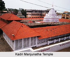
The Kadri Hill is famous for the 11th century Kadri Manjunatha Temple, with the surrounding tanks with natural springs and laterite caves, also known as the Pandava Caves. The bronze image of Lokeshawara and Lord Buddha in the Dhyani posture point to its Buddhist origins. The Kadri Kambala (Buffalo race) takes place here in December.
Kudroli Gokarnatheshwara Temple is set by Shri Narayana Guru, the great Philosopher, Saint and social reformer from Kerala. The temple is built in the Chola Gopuram Style. The main deity of this temple is Lord Shiva
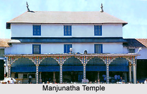
 Seventy five Kms east of Mangalore, set in sylvan surroundings on the lower slopes of the Western Ghats mountain range, the Dharmasthala Manjunatha temple is a well known pilgrimage centre and an interesting amalgam of faiths. The Manjunatha Temple is a prominent Shaivaite Center that has Madhwa Vaishnavaite priests and is administered by a hereditary Jain family, the Heggades.
The Jain influence can be seen in the 39 ft. statue of Bahubali, erected in 1980 on the hill near the temple. Opposite the temple is the Manjusha Museum which houses a wide rage of objects, including ancient scripts on palm leaves, silver jewellery and religious statuary. Charity is a way of life here and pilgrims that throng the temple are given free food and lodging for three days. During the annual festival, Laksha Deepotsava held in November-December, one lakh lamps are lit and literary and religious discourses are held.
Nestled between hills, this pilgrim centre, 104 Kms. from Mangalore is the famous temple of Kukke Sri Subrahmanya. The epics narrate how the divine serpent Vasuki and other snakes took refuge under God Subrahmanya, in the caves. Here God Subrahmanya is worshipped as a snake, which is the god`s divine power. A ritual dance called Nagamandala is performed during the worship, where the dancer wears the attire of Ardhanarishwara (half man, half woman), symbolising the concept of female (prakruthi) and male (purusha) forces being one. The Nagamandala dance form is a distinct feature of the state of Karnataka.
The Durga Parameswari Temple, located on an island in Nandini River is situated twenty Kms East of Mangalore. The chief deity is in the form of an udhbhava (naturally formed) linga. The pillars of the temple bear beautiful sculptures.
Apart from the above mentioned temples, there are a number of other temples in the district such as Kodiadka Sri Annapoorneshwari Temple, Southadka Sri Ganapathy temple, Sri Durga Parameshwari Temple, Sri Rajarajeswari Temple, Sri Mahalingeswara temple, Sri Karinjeshwara Temple, Sri Sahasralingeshwara Temple and Narahari Parvatha Sadashiva Temple. Also found here are places of worship belonging to other religions such as the St Aloysius church and the Ullal Darga.
St. Aloysius Church was built in the year 1899-1900, and is situated just 1 km from the heart of the city. The walls and ceilings of the church are covered by paintings of Antonio Moscheni of Italy.
The Ullal Darga is a famous darga in the region. It is the Darga of Sayed Mohammed Shereful Madani who is said to have come to Ullal from Madina 400 years ago. Thousands of people from various states visit the mosque to participate in the Urs festival which is celebrated once in every five years.
Located in Moodabidri, 35 Kms North East of Mangalore, the Holy shrine of the Jains, Thousand Pillar Basadi is dedicated to Shri Chandranath, a Jain saint. The temple is intricately carved and has Nepalese style of architecture. The 1000 pillar temple is around 560 years old and was build over a century. The history of the temple is carved on the walls and pillars of the Temple. No two pillars in the temple are alike. The Basadi is a treasure house of art and architecture.