Introduction
 Chamoli District is a district of pilgrimage importance, located in the north Indian state of Uttarakhand. Chamoli District is an outstanding spot filled with comprehensive qualities of nature that adds to its glory and splendour.
The majestic panoramic view of the lofty Great Himalayan ranges in Chamoli District, coated with white sheets of snow is just an eye soothing and awe-inspiring view. The lush green mountains, gushing rivers, holy pilgrimage centers of significant importance, and grandeur of locales, all these and many more add to the beauty of Chamoli District. Chamoli District is also adored for its shrines and temples of significant importance and this is the birthplace of the Chipko Movement.
History of Chamoli District
 According to the history of Chamoli District, the region covered by the present district of Chamoli formed part of Pauri Garhwal District of Kumaon till 1960. Today`s Garhwal was known as kedar-khand in the past. In the Puranas kedar-khand was said to be the abode of God. It seems from historical facts that these Hindu scriptures are scripted in kedar-khand. Mention of this region is also found in Rig Veda and other Vedic literature. The authentic script about the history of Chamoli District dates back to 6th century A.D.
Some historian and scientists believe that this land is origin of Arya race. It is believed that around 300 B.C. Khasa invaded Garhwal through Kashmir, Nepal and Kumaon. A conflict grew due to this invasion and a conflict took place between the outsiders and natives. The natives for their protection built small forts called "Garhi``. Later on Khasa defeated the native and captured the forts. After Khasas, Kshatriyas invaded this land. Further, according to history of Chamoli District, King Bhanu Pratap was the first ruler of Panwar dynasty in Garhwal who founded Chandpur-Garhi as his capital. This was the strongest garh out of the fifty- two Garhs of Garhwal. The devastating earthquake of September, 1803 weakened the economic and administrative set up of Garhwal state. Taking advantage of the situation Gorkhas attacked Garhwal. They established there reign over half of the Garhwal in 1804. Up to 1815 this region remained under the Gorkha rule.
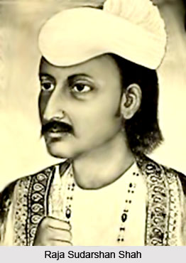
Mean while the king of Panwar dynasty Raja Sudarshan Shah contacted east India Company and requested for help. With the help of British forces he defeated Gorkhas and merged the eastern part of Alaknanda River and Mandakini, holy stream. From that time this region came to be known as British Garhwal and the capital of Garhwal was set up at Tehri. In the beginning British ruler kept this area under Dehradun and Saharanpur. But later on the British established a new district in this area and named it Pauri. Today`s Chamoli was a tehsil of the same .On 24th of February, 1960 tehsil Chamoli was upgraded to a new district. In October 1997 two complete tehsils and two other blocks (partially) of Chamoli District were merged into a new formed District Rudraprayag. Chamoli, carved as a separate revenue district in 1960 out of the erstwhile Garhwal district, lies in the Central Himalayas and constitutes a part of the celebrated `Kedar Kshetra` of Uttarakhand.
Geography of Chamoli District
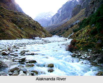
 Geography of Chamoli District includes that section of the Himalayan range that is deeply cut by the headwaters of Alaknanda River. The geology of the region of Chamoli District shows that the Himalayas are the young mountains in the world. Further, the geological feature of the district forms two major divisions which lies north and south of an imaginary line extending towards south-east between the villages of Hilang in Joshimath and Loharkhet in the adjoining area of Pithoragarh. The northern division, which is occupied by higher ranges and snow covered peaks entirely consist of medium to high grade metamorphic rocks and is intruded by later volcanic rocks. On the other hand, the division to the south, occupied by ranges of lower altitude, consists essentially of sedimentary and low grade metamorphic rock also intruded by later volcanic rocks. Geologically very little is known of the first division which consists of rocks such as quartzite and marbles. The division to the south of the imaginary line is better known geologically and consists of rocks such as gneisses, limestone, quartzite and slates.
As the elevation of Chamoli District ranges from 800 metres to 8000 metres above see level the climate of the district very largely depend on altitude. The winter season is from about mid November to March. As most of the region is situated on the southern slopes of the outer Himalayas, monsoon currents can enter through the valley, the rainfall being heaviest in the monsoon season from June to September. Most of the rainfall occurs during the period of June to September when 70 percent to 80 percent of the annual precipitation is accounted for in the southern half of the district and 55 to 65 percent in the northern half. The effectiveness of the rains is, among others, related to low temperature. However, the effectiveness is neither uniform nor even positive in areas where either the vegetation cover is poor or has steep slops or the soils have been so denuded that their moisture absorption capacity has become marginal.
The details of temperature recorded at the meteorological observatories in Chamoli District show that the highest temperature recorded here is 34 degree Celsius and lowest being zero. January is the coldest month after which the temperature begins to rise till June or July. Temperature varies with elevation. During the winter season cold waves in the wake of western disturbances may cause temperature to fall appreciably. Snow accumulation in valleys is considerable. The relative humidity is high during monsoon season, generally exceeding 70 percent on the average. The driest part of the year is the pre monsoon period when the humidity level may drop to 35 percent during the afternoon. During the winter months, humidity increases towards the afternoon at certain high stations. Skies are heavily clouded during the monsoon months and for short spells when the region is affected by the passage of western disturbances. During the rest of the year it remains generally clear.
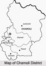
Chamoli District is surrounded by Uttarkashi in north-west, Pithoragarh in south-west, Almora in south east, Rudraprayag in south-west and Tehri Garhwal in west. Total geographical area of the district is around 7520 sq kms. Chamoli District is rich with several mineral resources. The minerals that are mainly found in the district include Asbestos, Soapstone or Steatite, Copper, Iron, Graphite, Gypsum, Lead, Slate, Limestone, Building Stone, Sulphur and Bitumen. Some other minerals found in the district are Antimony, Arsenic, Lignite or Brown Marble, Mica and silver. Physiographically the district, which lies in a region of tectonic or folded and over thrust mountain chains, has strata and is structurally marked by complex folds, reverse faults, over thrusts of great dimensions.
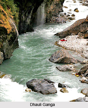
Chamoli District is criss-crossed by several important rivers and their tributaries. Alaknanda River, Saraswati River and Dhauli Ganga are some of the main rivers traversing through the district. The rivers of Chamoli District generally flow with great force in steep and narrow channels often resulting in excessive erosion and collapse of the banks.
Demography of Chamoli District
According to the Population census in the year 2011, Chamoli District had a population of 391,605. Out of which the male and the female were 193,991 and 197,614 respectively. In the population census in the year 2011, Chamoli District has the recorded increase of 13.87 percent to its population compared to 1991.
Culture of Chamoli District
 Culture of Chamoli District in Uttarakhand describes the lifestyle and traditional customs of the regional residents of this part of the country. Being the inhabitants of a mountainous region which are not influenced by the touch of urbanization, the people of Chamoli district follow their own distinctive and attractive culture, which is enriched with folksongs, folk dances, festivals and lots more. Various kinds of recreational activities are practiced by the local residents, who are fond of adorning themselves with ornaments of precious metals.
Housing Patterns of Chamoli District
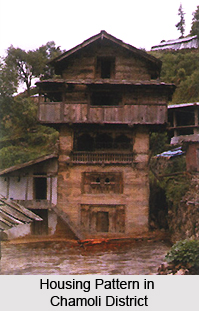
Residential houses in Chamoli are devoid of any specific constructional planning and created in clusters near water springs or river banks. Generally, these dwellings are double-storeyed and made of stone, equipped with courtyards at the front known as `Chauk`. One can reach the second storey which is 2.1 metres in height with the aide of a wooden or mud staircase. `Patals` or quartzite slabs are employed to build the roofs of such houses, which are sloped. Galvanized iron sheets are utilized as materials to construct the roof, by the wealthy inhabitants of Chamoli. Balconies are also present, adjoining the upper storeys. Certain houses possess five or even six storeys, wherein the uppermost storey is used as household kitchens. The cattle sheds are built at a short distance from the villages.
 Food in Chamoli District
Jhanjhora, maize, mandua, rice and wheat represent the staple die of the people of Chamoli district. However, mandua, maize and jhanjhora are mainly consumed by the poorer sections of the society. `Masor`, `Urad`, `Lopia`, `Tur`, `Bhatt`, `Soontha` and `Gahat` are some of the pulses which are eaten by the locals. The Hindus residing here are mostly vegetarian and are fond of vegetarian foodstuffs. Sikhs, Muslims and Christians are non vegetarians, who are unable to afford such food items due to shortage of funds.
Jewellery of Chamoli District
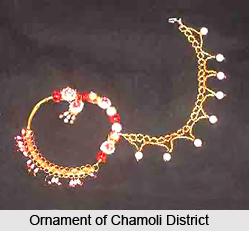
Married women love wearing `Bichhuwas` or toe- rings made of silver, while nose rings or `Naths` made of gold and small nose studs known as `Keels` are also worn by them. They are quite fond of decorating themselves with different types of jewelleries which involve `chandanhar` or necklaces, `hansulis` or ornaments worn around neck and also necklaces equipped with beautifully coloured beads. Silver or copper amulets are used by married women, and `churis` or bangles made of silver, gold or coloured glass are favourites of young girls and women. Bhotiya womenfolk are also known to wear jewels made of ivory and regional men of Chamoli wear gold chains around their neck.
Costumes of Chamoli District
Men wear a long shirt referred to as `Kurta` alongwith a `Pyjama`. A jacket or `sadri` and a cap are also worn by men during the winter season. Buttoned up coats teemed with trousers form the dress of the rich. Women of Chamoli generally wear `Angra` or a full-sleeved shirt, along with a saree. During winter, woollen jackets are also worn by the ladies. Rural women are clad in a long scarf which covers the neck and shoulders, termed as `Orhni` and a tight, long sleeved jacket. Salwar-Kameez is worn by the girls, with a `dupatta`, which is again a long scarf that covers the head and shoulders.
Recreation of Chamoli District
The regional inhabitants of Chamoli district perform several folk songs and folk dances for entertainment. The `Thadiya` dance practised during `Basant Panchami`, `Mela` performed in Diwali and `Pandava` during winter are some of the most popular local dances. `Ghariyali` and `Jeetu Bhagdawal` are amongst the other famous dances of Chamoli. Open-air theatre acts called `Swangs` are also arranged by the local residents of Chamoli to add to the fun quotient in fairs and festivals, religious and social congregations.
Fairs and Festivals of Chamoli District
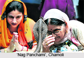
People of Chamoli district celebrate innumerable festivals and organise wonderful fairs which consist of `Nag Panchami`, `Ram Navami`, `Dussehra`, `Janmashtami`, `Makar Sankranti`, Diwali, `Raksha Bandhan`, Holi and `Shivaratri`. The various fairs hosted here are `Gaucher Mela`, `Nanda Devi Raj Jat`, and so on.
Administration of Chamoli District
The administration of Chamoli district is completely dependent on the District Collector and the regions of assemble constituencies. Chamoli District has three constituencies like Badrinath, Karnprayag and Tharali.
Economy of Chamoli District
Chamoli district is economically dependent on agriculture, handloom and tourism. Here the wheat, rice and maize are produced in the remote villages of Chamoli District.
Fairs and Festivals of Chamoli District
Fairs and festivals of Chamoli District in Uttarakhand are celebrated by the regional residents of this part of the country and reflect the tastes and culture of the people of Chamoli. Such festive occasions are held throughout the year and play a significant role in the lives of the local inhabitants. `Nag Panchami`, `Ram Navami`, `Makar Sankranti`, `Nanda Devi Raj Jat`, `Gaucher Mela` and `Janmashtami` are some of the several fairs and festive events which are organised with great enthusiasm here. Millions of people pay a visit to Chamoli District during these festivals, to participate in all the fun and frolic associated with these programmes.
Nag Panchami
Nag Panchami is observed during the 5th day of the Hindu month of `Shravana`, to honour the serpent Gods, or the `Nagas`. People draw images of snakes with the aide of flour over wooden boards and worship it by making offerings of rice, flowers and milk.
Ram Navami
This festival is celebrated on the 9th day of `Chaitra` month, in order to commemorate Lord Rama`s birthday. Devotees of this Hindu deity observe a fast throughout the entire day and recite Ramayana. The assembled guests sit attentively and listen to the recitations of Ramayana.
Holi
Also known as the spring festival, Holi is celebrated with gusto during full moon day of the month of `Phalgun`. Songs of Phalgun, popularly termed as `Phaags`, are sung by the regional people of Chamoli, particularly at nights, much prior to the actual festival. On the 11th day of Phalgun, a flag is established inside the village which is burnt on the 15th day. This event is called `Chharoli` and an ash mark is applied on the foreheads of near and dear ones. On the very next day, people rejoice by throwing coloured water and coloured powder over each other, followed by a visit to the residences of relatives in the evening.
Raksha Bandhan
Raksha Bandhan is observed during the final day of the month of Shravana. Sisters tie a thread of protection known as `Rakshasutra`, which is also referred to as `Rakhi`, around the right wrist of brothers. Such an action signifies the purity and love of the relationship between a brother and a sister, and the blessings of brothers on their sisters. During Raksha Bandhan, fairs are conducted at Nandaprayag, Karnaprayag and Kedarnath.
Bishwat Sankranti
Bishwat Sankranti is a fair which is organised on the 13th day of the month of April, and it finds a mention in Lalitashuradeva`s Pandukeshwar inscription. This fair is a grand congregation of innumerable visitors which is also held in Hans Koti, Aser, Adbadri, Kulsari and Ming.
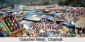
Gaucher Fair
Gaucher Fair is so named since it is held at the area of Gaucher which is situated at Karnaprayag in November, and is thronged by numerable tourists.
Nanda Devi Raj Jat
Nanda Devi Raj Jat is a renowned pilgrimage of the deity of Nandadevi, and is exclusively conducted in Chamoli District. It has been continuing since the 9th century. This grand fair is associated to a local legendary folklore and involves a large procession which ascends the mountains at Jiuri Gali Dhar which measure about 5335 metres in height and Nauti, which are about 900 metres, and also cover large distances, barefoot, crossing forests and snow-covered hilly tracts.
Other Fairs and Festivals of Chamoli District
The natives of Chamoli District observe many other interesting festivals and fairs like Dussehra, Deepavali, Shivaratri and `Nautha` at Adbadri, Dattatreya Pooranmasi at Anusuya Temple, `Naumi` at Hariyali, `Nanda Devi` at the region of Bedni respectively.
Nag Panchami
Nag Panchami is observed during the 5th day of the Hindu month of `Shravana`, to honour the serpent Gods, or the `Nagas`. People draw images of snakes with the aide of flour over wooden boards and worship it by making offerings of rice, flowers and milk.
Ram Navami
This festival is celebrated on the 9th day of `Chaitra` month, in order to commemorate Lord Rama`s birthday. Devotees of this Hindu deity observe a fast throughout the entire day and recite Ramayana. The assembled guests sit attentively and listen to the recitations of Ramayana.
Holi
Also known as the spring festival, Holi is celebrated with gusto during full moon day of the month of `Phalgun`. Songs of Phalgun, popularly termed as `Phaags`, are sung by the regional people of Chamoli, particularly at nights, much prior to the actual festival. On the 11th day of Phalgun, a flag is established inside the village which is burnt on the 15th day. This event is called `Chharoli` and an ash mark is applied on the foreheads of near and dear ones. On the very next day, people rejoice by throwing coloured water and coloured powder over each other, followed by a visit to the residences of relatives in the evening.
Raksha Bandhan
Raksha Bandhan is observed during the final day of the month of Shravana. Sisters tie a thread of protection known as `Rakshasutra`, which is also referred to as `Rakhi`, around the right wrist of brothers. Such an action signifies the purity and love of the relationship between a brother and a sister, and the blessings of brothers on their sisters. During Raksha Bandhan, fairs are conducted at Nandaprayag, Karnaprayag and Kedarnath.
Bishwat Sankranti
Bishwat Sankranti is a fair which is organised on the 13th day of the month of April, and it finds a mention in Lalitashuradeva`s Pandukeshwar inscription. This fair is a grand congregation of innumerable visitors which is also held in Hans Koti, Aser, Adbadri, Kulsari and Ming.
Gaucher Fair
Gaucher Fair is so named since it is held at the area of Gaucher which is situated at Karnaprayag in November, and is thronged by numerable tourists.
Nanda Devi Raj Jat
Nanda Devi Raj Jat is a renowned pilgrimage of the deity of Nandadevi, and is exclusively conducted in Chamoli District. It has been continuing since the 9th century. This grand fair is associated to a local legendary folklore and involves a large procession which ascends the mountains at Jiuri Gali Dhar which measure about 5335 metres in height and Nauti, which are about 900 metres, and also cover large distances, barefoot, crossing forests and snow-covered hilly tracts.
Other Fairs and Festivals of Chamoli District
The natives of Chamoli District observe many other interesting festivals and fairs like Dussehra, Deepavali, Shivaratri and `Nautha` at Adbadri, Dattatreya Pooranmasi at Anusuya Temple, `Naumi` at Hariyali, `Nanda Devi` at the region of Bedni respectively.
Temples in Chamoli District
 There are several noteworthy temples in Chamoli District. Most of the temples of this district of Uttarakhand are dedicated to Lord Shiva. Another interesting feature of the temples in Chamoli District is their beautiful location. Most of them are located amidst beautiful valleys. They attract devotees from far and wide. Temples of this region are very popular worldwide and details about some of them are given below -
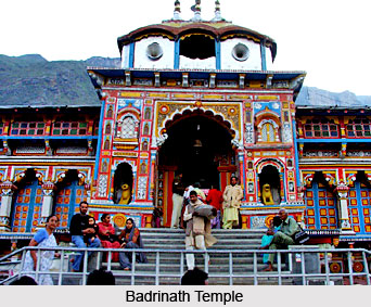
Badrinath Temple: Badrinath is one of the `four dhams` of the country and is situated at an elevation of 3,133 metres above sea-level. It is flanked by two mountain ranges known as Nar and Narayan, with the towering Neelkanth peak providing a splendid backdrop. This reversed spot was once covered with wild berries which gave it the name `Badri Van`, meaning `forest of berries`. Facing the temple at the bank of Alaknanda River is a hot water spring known as `Tapt Kund`. The temple opens every year in the months of April and May and closes during the winter season that is around the third week of November. It is believed that worshipping at this shrine is a means of liberating the soul from the bound of transmigration. The original temple that was here is said to have been of very great antiquity. The present temple was built around 400 years ago by the king of Garhwal. The principal idol in the temple, which is of black marble and is about a metre in height, is that of Lord Vishnu. In the courtyard of the temple, to the right, stands a small shrine dedicated to Goddess Laxmi.
 Narasingha Temple: The temple is situated in the heart of Joshimath on the old route to Badrinath. Of all the temples in Joshimath, Narasingha Temple is considered as the most magnificent one. Carved from the Shaligram it was supposedly crafted during the reign of King Lalitaditya Yukta Pida of Kashmir. The Narasingha legend is a fascinating one.
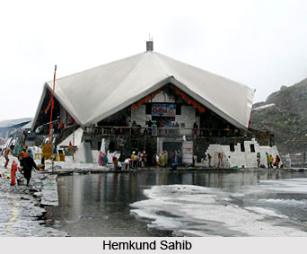
Hemkund Sahib: Hemkund (literally means `lake of gold`), is situated nearly 29 kms from Joshimath, is set in one of the famous beauty spots of the central Himalayas and has a lake of crystal clear water located amidst beautiful surrounding. It is believed that Guru Gobind Singh had meditated on the bank of this lake in one of his earlier births. A Gurudwara and a Lakshmana Temple was built on the bank of this lake. It is believed Lakshmana was brought here after he fell unconscious in the war with Ravana.
Uma Devi Temple: The Uma Devi temple is situated at the confluence of the Pindari Glacier and Alaknanda River in the town of Karanprayag. The old temple is named after Uma Devi or Parvati. Close to it there is a temple dedicated to Lord Shiva. Large crowds assemble here on the occasion of Shivaratri.
 Bhavishya Badri: The temple of Bhavishya Badri is located at about 17 kms from Joshimath. It has an altitude of 2744 metres and is located within dense forest. Several legends are associated with this temple.
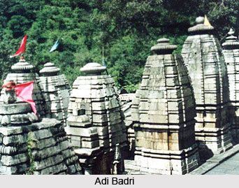
Adi Badri: Adi Badri is said to be the abode of Lord Badrinath. Just above Adbadri is the small Lake of Benital. At Adi Badri the remains of sixteen temples similar to those found at Dwarahat (in Almora District) can be found. It is one of the Panch Badri, others being Vishal Badri, Yog-Dhyan Badri, Vriddha Badri and Bhavishya Badri. All five shrines are situated in close proximity.
Gopinath Temple (Shiva temple): Gopinath temple is situated at Gopeshwar which is 10 kms from Chamoli. The temple is topped by a dome and 24 doors leads to the sanctum sanctorum, which is around 30 sq feet in area. There are several broken idols around the temple which support the theory that in ancient times there were several more temples in Gopeshwar.
Rudranath Temple: It is one of the Panch Kedars. This temple is dedicated to Lord Shiva. The temple is situated amid thick forests at a height 2286 metres. The temple provides magnificent view of Hathi Parbat, Nanda Devi, Nanda Ghunti, Trisuli Peak and many others. There are a number of holy Kunds or Tanks near Rudranath Temple namely Suryakund, Chandrakund, Tarakund etc.
Yogdhyan Badri Temple: The Yogdhyan Badri Temple is as old as the temple of Badrinath. Some famous copper plate carrying old inscriptions providing valuable information on the history of the temple and early Katyuri Rajas have been found here. Surya Kund, which is on the top of Milam glacier, is a hot water spring.
Forests of Chamoli District
 Forests of Chamoli District can be categorised into several botanical divisions. As this district of Uttarakhand has vast forest lands, it is blessed with rich and diverse flora and fauna. The botanical divisions of the forests of Chamoli District vary as per the elevation of its different ranges. The major botanical categories of Chamoli District are as follows -
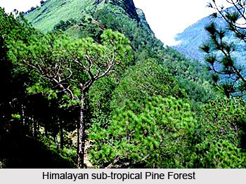
Himalayan sub-tropical Pine: These forests are found between the heights of 910 metres to 1825 metres throughout Chamoli District. The trees which are commonly found in these forests are Anyar, Caryoptexis wallichii, Rubus ellipticus and Rhus semialata on the northern aspect of the hills.
Moist Temperate Seral Forest: These forests are found between the altitudes of 1200 metres to 2150 metres along the streams and newly formed beds with undergrowth of Sarococca preuniformus spp, Berberis spp and Ainslea aptera especially in the western part of the Joshimath and the eastern part of Karnprayag tehsils.
Banj Oak Forests: These forests are basically found between the heights of 1825 metres and 2450 metres. But at certain places their limits ascent up to 2600 metres especially on the southern aspect and descend to 1200 metres on the northern aspect of the hills. Trees commonly met with in these forests are buras, anyar, carpinus,viminea and Ilex odorala.
 Tilonj Forests: These forests are found between the same altitudes as those of the oak and are associated with the lauracea, ilex, betula alnoides, etc. The shrubby under growth consist of Robus spirea, indigofera and Ainslea aftera.
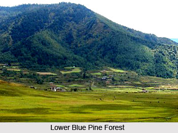
Lower Blue Pine Forests: These forests are found between the heights of 1825 metres and 2600 metres especially in Tehsil Chamoli and Karnprayag having Euscholtzia polistachya, Vibumun foctens, Rosa microphylla, Vibumun cotonifoliun, Exaecarea acerifolia, etc. as shrubby under growth.
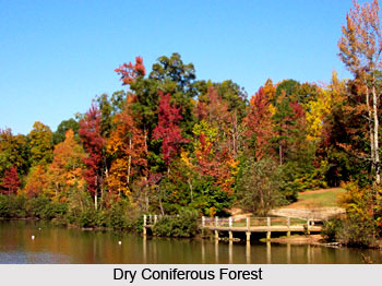
Dry Coniferous Forest: On deep soil between the altitude of 1825 metres and 2600 metres. The under growth consist of shrubs such as Aveliatryflora, Sumiperous, Macropoda, Prunus jacqumontii, Ribes grosulaia and Rosa scricea, the shrubby under growth consisting of Achyranthes bidentata and Aralia cissifolium.
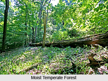
Moist Temperate Deciduous Forest: These forests are found on deep moist soils between the heights of 1825 metres and 2750 metres along the hill stream. The top canopy consist of pangar, kanchula, maira sour, akhrot, dalla and kabasi, the shrubby under growth consisting of viburum spirea, sorbiflora, barberis spp, Strodilanthas wallichii , etc.
Cypress Forests: These forests are found between the heights of 2125 metres and 2600 metres on rocky slopes and precipitous grounds.
 Kharasu Forests: The Kharasu forests are found between the heights of 2450 metres and 3500 metres mixed with kanchula, pangar, saur and burans. The shrubby undergrowth consists of Rosa scricea, Rosa macrephylla, Viburum foeten, Contoneaster ocuminate and Ribes glaciaia.
Western Oak Forests: These forests are commonly found on the southern aspect of hills between the altitudes of 2450 metres and 2900 metres mixed with Kharasu, tilonj, pangar, kanchula, kabasi, etc. the chief undergrowth being Rhamnus purpurrea, Wickstroemia cancacenda, Rosa macrophylla, Skimmia bursola, Rubus niveus. Among creepers which are found here are Vitis semicordata, Schizandras grandiflora and Hedera helix.
Dry Temperate Deciduous Forests: These forests consisting of kabasi trees are found between the heights of 2450 metres and 2750 metres in the northern part of the district.
Temperate Hippophae Scrub Forests: These forests consisting of ames scrubs, are found between the heights of 2275 metres and 3200 metres on gravel beds along the banks of the streams mixed with gadbhains.
Kharak Forests: These forests are found above the altitude of 2215 metres and have practically no tree growth except the Rumex nepalensis undergrowth.
 Alpine Fir Birch Forests: These grow better between the heights of 2900 metres and 3500 metres in all aspects of the hills except in the moist areas. The plants growing in these forests are fir, birch and Rhododendron.
Birch - Rhododendrons Forests: These forests are found between the altitudes of 2900 metres and 4125 metres and in them are found the stunted bhuj and rhododendrons with Pyrus foliolose as 90 percent of the undergrowth. Other plants which grow here are Rubus niveus, Swilax vaginate, Cotoneaster spp, Lonicera spp and Pologorum vaccinifolium.
Alpine Scrub Forests: Between the altitudes of 3350 metres and 4275 metres and with a rainfall above 1016 mm. Evergreen scrubs are found consisting of Rhododendron asthopogen, Junipexus recurva, J. communis, Lonicera parviflora, etc.
Alpine Pastures: Between the heights of 2050 metres and 2975 metres on the northern aspect of the hills and between the altitudes of 2500 metres and 4425 metres on the southern aspect of the hills the land is covered with short grasses and herbs.
In the warm valleys of the extreme southern part of the district some species of the trees of the plains such as mango, Peepul, banyan and shisham grow here and there up to an altitude of about 915 metres. In the Alaknanda valley, the bases, slopes, gorges and tops of the hills up to the height of 1067 metres are well wooded with high trees such as catechu, bahera, amaltas, bel, kachnar and dhak. A large variety of creepers some of which have broad green leaves also thrive in the vicinity of the trees. Above an elevation of 3439 metres Moru or Tilonj and Kharasu grow and their timber is also used for manufacturing agricultural implements. Many medicinal blooms, herbs and plants, greatly valued in Ayurveda grow in Chamoli district. The chief varieties of timber trees found in the groves of the district are pine, deodar and many varieties of walnut. The timber of the deodar tree is considered to be sacred and is noted for durability and resisting insect, pest and dry rot. It is great demand for making doors and roof of temples.
Forests of Chamoli District are rich in fauna and have been the habitat, from time immemorial, of a large variety of mammals, various species of birds, reptiles and fish. However, presently the number of wild animals has considerably decreased on account of their destruction and thinning of the forests.
Tourism of Chamoli District
 Tourism in Chamoli District will include visits to some of the most impressive places surrounded with natural scenery, water bodies and diverse wildlife. Chamoli District is known for its holy sites, temples, snow clad mountain peaks and beautiful scenic beauty. Chamoli District is blessed with diverse species of flora and fauna and natural splendor. Some of the main tourist attractions of Chamoli District are as follows -
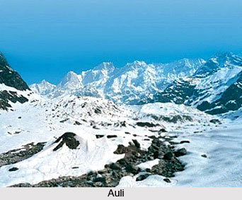
Auli: Auli is inviting in the summer season but in the winter season it is irresistible with its white snow slopes and skiing facilities. Auli can be reached by road or ropeway from Joshimath. It provides an excellent panoramic view of the giant mountain peaks like Nanda Devi, Kamet Peak and Dunagiri Peak. From January to March, Auli slopes are usually covered with a thick carpet of snow, about 3 metres deep. It offers a good skiing ground for the adventure lovers. The background of lofty snow clad mountains increases the sprit of the skiers. Moreover, to attract the attention of the travellers, skiing festivals are also conducted at Auli. While skiing is the chief attraction at Auli, there are other attractions like cable car rides and rope lifts.
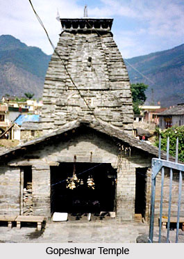 Gopeshwar: Situated at a height of 1308 metres amidst beautiful mountain ranges, terrace farms and small lakes, is the picturesque township of Gopeshwar. An ancient temple of Lord Shiva is the main attraction of the town and thousands of pilgrims come here throughout the year to visit the temple. Owing to its natural beauty and fresh and serene atmosphere, Gopeshwar is becoming a major attraction for the tourists. Many well known tourist spots and religious centres are spread around this town. According to historians, the name Gopeshwar has associations with the name of Lord Krishna. Besides the ancient temple of Lord Shiva, Baitarni Kund is another major attraction of the town.
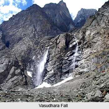
Vasudhara Fall: 5 kms from Mana village, toward the west is the Vasudhara fall, set in a background of snowy peaks, glaciers and rocky heights. Its view is breath taking.
Valley of Flowers: A profusion of wildflowers - iris, violets, roses, anemones, potentillas - mark this valley. It is celebrated all over the world for its lush beauty. A narrow river flows through the valley, now declared a national park. The best time to visit the valley is during July and August when innumerable varieties of flowers bloom and present a spectacular sight. The valley itself is 10 kms long and about 2 kms wide in conical shape.
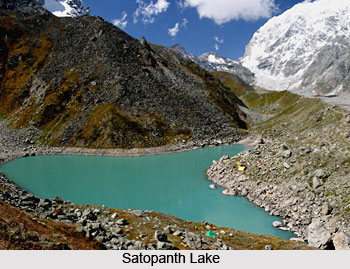
Satopanth Lake: This triangular lake of serene water has a perimetre of about half a kilometer. It is about 25 kms from Badrinath. Lord Brahma, Lord Vishnu and Lord Shiva, the Hindu trinity is believed to occupy one corner each, and which are named after them. The trek is hazardous, but full of adventure.
Bedni Bugyal: Situated near Wan, Bedni Bugyal is a charming green meadow adorned with flowers in a spell binding varieties, in full bloom. There is a small lake situated in the midst of the meadow, where `Tarpans` are offered by the devotees.
 Roopkund: Roopkund is situated in the eastern part of Chamoli District. It is not a very large kund and is rather shallow, having a depth of only about 2 metres. The edges are snow covered for most parts of the year.
Badrinath: Badrinath is one of the `four dhams` of the country and is situated at an elevation of 3,133 metres above sea-level. Facing the temple at the bank of Alaknanda River is a hot water spring known as `Tapt Kund`.
Tapovan: In contrast to the annoying hustle and bustle of city life of Joshimath, Tapovan is a peaceful place known for its hot springs which are believed to possess miraculous healing powers. Tapovan is 15 kms from Joshimath.
Gwaldam: About 3 Kms from Baijnath, the main highways goes to Bageshwar and a side road branches off to Gwaldam. This is a delightful route as besides the presence of birds, adding a winsome note, one passes through terraced fields and thick pines set against a backdrop of the Himalayas, and one can watch the Trishul peaks coming even closer. Gwaldam with its salubrious climate is a little heaven nestling in the woods. In this area, upto Talwari , there are several orchards generally of apple. From Gwaldam, the road winds its way through dense forests and terraced fields dotted with rustic cottages of small towns known as Tharali and Narain Bagar to meet the Ranikhet-Pandukhal road at a place called Simli, which is 8 Km short of Karnaprayag. Gwaldam is 149 Km from Nanital and 22 km from Baijnath.
Joshimath: Joshimath has a temple dedicated to Narshimsha, an incarnation of Vishnu. There are several temples located here.
 Kagbhusandi Lake: This is a small oblong lake with emerald green water. It is at an altitude of 5230 metres, and is almost a km in length. Myriad blossoms decorate its banks. Set in the lap of Hathi Parbat (6730 metres), the lake can be approached either from Bhiundhar village, near Ghangria, or from Vishnu Prayag.
Nanda Devi Sanctuary: Nanda Devi Sanctuary has been converted to a National Park and temporarily closed for visitors on environmental considerations. It has an average altitude exceeding 4500 metres and is surrounded several peaks, Nanda Devi being the highest. It is in the form of cup with lush green meadows, waterfalls, and rich wild flora and fauna.
Hemkund Sahib: Hemkund (Lake of gold), is situated nearly 29 kms from Joshimath. It is believed that Guru Gobind Singh had meditated on the bank of this lake in one of his earlier births.
Kuari Pass: Standing at the Kuari Pass facing north, the vision sweeps from the gorges of Trishul in the east to the peaks of Kedarnath in the west. One can approach the Pass from Tapovan. The entire area is rich in exotic flora and fauna
Rudranath Temple: It is one of the Panch Kedars of the country. Lord Shiva is worshipped here as Neelkantha. The temple is situated amid thick forest at a height 2286 metres.
Visiting Information
The nearest airport for reaching Chamoli District is Jolly Grant Airport in Dehradun, which is located at a distance of 221kms. The nearest railway station is Rishikesh sited at a distance of about 202kms. Chamoli District is well linked to major parts of this state and all the cities of India by road.