
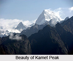
 Kamet Peak is the second highest peak in the Garhwal region after Nanda Devi. It is situated in the Uttarakhand state of India which is often referred to as the "Land of the Gods". The height of the Kamet peak is around 7,816 m (25,643 ft). It was first climbed in 1931.
Location of Kamet Peak
It is located in the Chamoli district of Uttarakhand, close to the border with Tibet. Kamet Peak is positioned at a height of 7,816 meters (25,643 feet) above mean sea level.
Nomenclature of Kamet
The term Kamet has different meanings and spellings as different author gives varying explanation to the word. According to C. F. Meade, Kamet is known to Tibetans as `Kangmen` which signifies `huge grandmother of a sacred snow chain`. While, Frank Smythe writes in his book `Kamet Conquered` that Kamet comes from the Tibetan word `Kangmed`.
 Attractions of Kamet Peak
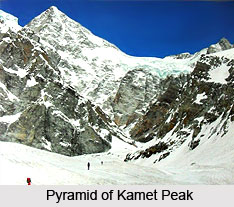
Kamet Peak is the third highest mountain peak in India and the twenty- ninth highest peak in the world. It looks like a giant pyramid topped by a flat summit area with two peaks.
Kamet is considered as the part of the Zaskar Range, which lies in the north of the Himalayas between the Suru River and the upper Karnali River. Three significant peaks bound Kamet, the Mukut Parbatin the northwest of Kamet, Abi Gamin and Mana, which is in the south-southeast of Kamet.
The other natural beauties that surround Kamet are the soothing glaciers and rivers. It is enveloped by the West Kamet Glacier, the East Kamet Glacier and the Raikana Glacier systems. The branches of the West Kamet Glacier can be seen heading on the western slopes of Kamet, Abi Gamin, and Mukut Parbat. The East Kamet Glacier flows from the eastern side of Kamet and Mana. The Raikhana glacier flows east of Abi Gamin and unites with the East Kamet Glacier. The West Kamet Glacier drains into the Saraswati River while the East Kamet Glacier into the Dhauliganga River. These two rivers are tributaries of the Alaknanda River which is the major river of Northern India and the holy river of Hinduism.









