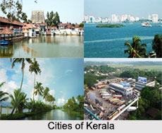
Introduction
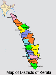
Alappuzha is one of the fourteen districts in the state of Kerala, which forms part of the Indian subcontinent. The history of Alappuzha can be traced back to the middle Ages. This place is also regarded as the `Venice of the East`. The district of Alappuzha made its appearance in the map of Kerala on 27th August 1957. Alappuzha consists of six taluks, two revenue divisions, and 91 revenue villages.

There are 71 panchayat districts in the district. Ernakulam and Kottayam districts, on the east by Pathanamthitta, on the southeast by Kollam district and on the west by the Arabian Sea, bound the Alappuzha district on the northeast. A major part of this district was under the Kollam and Kottayam district before the formation of this region. The climate of the district of Alappuzha is moist and hot in the coast and it is slightly cooler and drier in the interior parts of the district. The historical significance of this district is glorious with its abundant trade activity. This district is also famous for the first labor upsurges against the autocratic regime.
Demography of Alappuzha District
In regard to the density of the population Alappuzha is among the foremost of the districts of the state of Kerala. In respect of its literacy rate also it stands first among the other districts of this state. It is the only district of Kerala, which has no area under the high lands. The rice bowl also known as `Kuttanad` is in Alappuzha. The total production of rice here is ten percent of the total production of the entire state. It is also regarded as the most important center in the state of Kerala for coir industry because most of the coir factories of the state are sited in this district. The port of Alappuzha owes its origin to the ingenuity and imagination of a great administrator known as Raja Kesavadas who constructed the two chief canals running parallel to each other through the heart of the town connecting the backwaters and the seashore. In 1792 the port was open for foreign trade. In the year of 1862 the lighthouse was put under the supervision of a European engineer Mr. Crawford. The growth and development of the Cochin harbor marks the beginning of the decline of the market and port of Alappuzha.

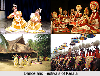
Art and Culture of Alappuzha District
The culture and the tradition of Alappuzha district are almost similar to that of the other districts of Central Kerala. This district has made a significant contribution in the development of Malayalam language and literature. The district can also be proud of being the center of the snake boat races. In the arena of trade and industry Alappuzha still remains a central market in the state of Kerala and supports in the production of coconut oil, copra, oil cakes and coir. It is also the major production center of coir and various types of coir products in the state. In the fisheries map also this district has carved a niche for itself. The Arabian Sea being on its western boundary Alappuzha has rich marine resources. No important daily is published in Alappuzha but the various media of mass communication including radio, newspapers, and films are playing a very important role in the educational and the cultural development of the state. In the present times reaching Alappuzha has become very convenient as with the opening of Alappuzha-Changanacherry road in the year 1958 the district has the credit of having a network of good motorable roads. The commercial canals connecting the nook and the corner of the district of Alappuzha are also considered as its lifeline.
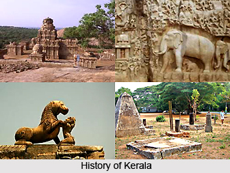
History of Alappuzha District
History of Alappuzha District unfolds its wonderful past. The present Allepey town owes its existence to the sagacious Diwan Raja Kesavadas in the second half of 18th century. Kuttanad, the rice bowl of Kerala with the endless stretch of paddy fields, small streams and canals with lush green coconut palms, was well known even from the early periods of the Sangam age. Alappuzha had trade relations with ancient Greece and Rome back in the middle Ages.
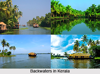
The word Alappuzha is derived from two words, Ala means `broad` and Puzha means `river`. Alappuzha has immense potential for the ever-expanding tourism industry in Kerala, which is located in South India. Alappuzha, flanked by the Arabian Sea on one side is one of the most important backwater destinations in Kerala.
In earlier days this place was known as Alleppey, and during that time in the first decade of the 20th century the then Viceroy of the Indian Empire, Lord Curzon visited the state. Seeing the exhilarant beauty of the place he was mesmerized and named the place as "Venice of the East". In the world tourism map this place is known by this name also. This place is very much famous for its houseboat holidays, coir industry, picturesque lagoons, rich and profuse marine life, etc. which has aided in developing the tourism industry of Alappuzha.

Alappuzha District was formerly connected with Kottayam and Kollam districts, but on 17th of August, 1957, alleppey was formed as an individual district. And later it was adapted as `Alappuzha`. The area transferred from the former Alappuzha district to Pathanamthitta district is Thiruvalla taluk as a whole and part of Chengannur and Mavelikkara Taluks. Thus the present Alappuzha district comprises of six taluks namely Cherthala, Ambalapuzha, Kuttanad, Karthikappllly, Chengannur and Mavelikkara.
The history of the Alappuzha District in the Paleolithic age is not that much known to anyone. It is presumed that the coastal taluks of Cherthala. Ambalapuzha and Karthikappally might have been under water and these areas were formed afterwards by the accumulation of silt and sand than the other parts of the district. In the early periods of the Sangam age, there was a well-known place called Kuttanad. The early Cheras, who had their home in Kuttanad were called `Kuttuvans` named after this place.
The literary works like "Unninili Sandesam" give some insight into the ancient period of this district. Christianity had a strong foothold in this district even from the 1st century A.D. The church located at Kokkomangalam or Kokkothamangalam was one of the seven churches founded by St.Thomas who was one of the twelve disciples of Jesus Christ. It is believed that he landed at Maliankara in Muziris Port, presently known as Kodungallur in 52 A.D and preached Christianity in South India. The district flourished in the field of religion and culture under the second Chera Empire during 9th to 12th century AD.

During16th century small princedoms like Kayamkulam which is presently known as Karthikappally and Mavelikkara taluks, Purakkad which was often called Ambalappuzha or Chempakasseri but presently known as Ambalappuzha and Kuttanad taluk and Karappuram comprising of two lands, called Moothedath and Iledath presently known as Cherthala Taluk emerged into power. In the political scene of the district, the Portugese came into prominence at that period. Christianity became popular and they built several churches all over the districts of which Churches located at Purakkad and Arthungal are well known.
The kingdom of Chempakasseri was at its zenith during the reign of Pooradam Thirunal Devanarayana. He was a great scholar and the author of `Vedantha Retnamala`, which was a commentary on the first verse of Bhagavat Geetha. It is said that Sreekrishna Swami temple at Ambalappuzha was constructed at that time where the idol of Lord Krishna was installed religiously. It is believed that Melpathur Narayana Bhattathiri, Sri Neelakanta Deekshithar and Sri Kumaran Namboothiri were some of the eminent scholars who patronized his court.
In the 17th century the Portuguese power declined and the Dutch had a predominant position in the principalities of this district. They built so many factories and warehouses in various places of it for storing pepper, ginger because of the fact that several treaties were signed between the Dutch and the Rajas of Purakkad, Kayamkulam and Karappuram. In course of time they also derived in the political and cultural affairs of the district. At that time Maharaja Marthandavarma, who was the `Maker of modern Travancore` intervened in the political affairs of those princedoms.
The scenario, which, was made with the annexation of the Kingdoms of Kayamkulam, Ambalappuzha, Thekkumkur, Vadakkumkur and Karappuram to travancore, gave the Dutch a setback from the political scene of the district. Marthandavarma Maharaja had a remarkable role in the internal progress of the district. He also gave special attention to the development of Mavelikkara as an administrative as well as a commercial centre. During this period the Krishnapuram plalace, was constructed which is now a protected monument of the State Archaeology department. The great and talented poet Kunjan Nambiar was placed in the court at Trivandrum at that time.

The district was improved by all means during the reign of Dharmaraja. The then Diwan of Travancore Raja Kesava Das, popularly known as the `Maker of modern Alleppey` made Alappuzha a premier port town of Travancore. He constructed several roads and canals to improve communications and built warehouses. He also gave all facilities to merchants and traders from far and wide. He is the chief architect of Alapuzha town. He found Alappuzha to be a perfect location for a port. Two parallel canals were constructed for bringing goods to the port. He also offered infrastructural facilities to merchants and traders from Surat, Mumbai and Kachchh in order to start industrial enterprises, trading and cargo centres. During the reign of Balaramavarma Maharaja, Velu Thampi Dalava took keen interest in the development of the town and port. He promoted coconut cultivation in the whole area of the island Pathiramanal and paddy cultivation on the large tracts.
In the 19th century the district arrived at progress in all spheres. One of the five subordinate courts opened in the state in connection with the reorganization of the judicial system by Colonel Munro. This was located at Mavelikkara. The first post office and first telegraph office in the former Travancore state was established in this district. The first manufacturing factory for the coir mats was also established here in 1859. In 1894 the town Improvement Committee was set up.
Alappuzha District played a prominent role in the freedom struggle of the country. The historic struggles of Punnapra and Vayalar in 1946 constrained the attitude of the people against Sir C.P.Ramaswamy Iyer, who was Diwan of Travancore. This ultimately led to his exit from the political scene of Travancore. A popular Ministry was formed in Travancore on 24th March 1948 after India`s independence, and on 1st July 1949 Travancore and Cochin states were integrated.
Geography of Alappuzha District
Alappuzha district is a sandy strip of land intercepted by lagoons, rivers and canals. The district lies between 9 degrees 5 minutes and 9 degrees 54 minutes north latitude, and between 76 degrees 17 minutes and 76 degrees 40 minutes` east longitudes. It covers a total area of 1414 Sq. Kms which constitutes 3.64 percent of the total area of the state. Alappuzha district is bounded on the north by Kochi and Kanayannur Taluks of Ernakulam district; on the east by Vaikom, Kottayam and Changanassery Taluks of Kottayam district and Thiruvalla, Kozhencherry and Adoor taluks of Pathanamthitta District; on the south by Kunnathur and Karunagappally of Kollam District and on the west by Lakshadweep (Arabian Sea.)
Within the district, Cherthala, Ambalappuzha, Kuttanad and Karthikappally lie completely in the low land region. There is no forest area in the district, and any mountains or hills either except for some scattered hillocks lying between the Bharanikkavu and Chngannur blocks in the eastern portion of the district.

Alappuzha has a flat, unbroken sea coast of 82 Km length which is 13.9 percent of the total coastal line of the state. An interesting phenomenon of this seacoast during the month of June is the periodic shifting of mud bank popularly known as "Chakara" within a range of 25 Km in Alappuzha-Purakkad coast due to hydraulic pressure when the level of backwater rises during south-west monsoon. The climate in the district is moist and hot in the coast and slightly cool and dry in the interior parts of the district. The average monthly temperature is 25 degree Celsius. The district also gets the benefit of two outstanding monsoons as in the case of other parts of the state. The hottest month is from March to May. The South-west monsoon is prevalent between the months of June to September, and the North-east monsoon between the months of October to November. The average rainfall in the district is 2763 mm.
The two most important minerals which occur in large quantities in the district are glass and foundry sand. Lime shell is exploited commercially. High quality sand deposits occur between Alappuzha and Cherthala which form a stretch of 35 Km in length along the western side of Vembanad Lake. Large quantities of sand are being mined at Pallipuram for manufacturing sand lime bricks. Vast deposits of lime shell occur in Vembanad Lake covering an area of 15 Sq.Km. up to a depth of 8 metres between Pathiramanal and Vaikom. China clay and ordinary clay occur in various places and are used as building materials. The raw material required for granite carving is obtained from Chengannur.

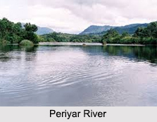
The district has a network of rivers, canals and backwaters. Manimala, Pampa and Achancovil are the major rivers. The Manimala River originates from Mothavara hills in Kottayam district enters the district at Thalavadi village in Kuttanad taluk and passes through Edathua and Champakulam villages and joins the Pamba River at Muttar. It has a length of 91.73 Km and drainage area of 802.90 Km. Achankovil River, often known as Kulallada river, originates from Pasukida mettu, Ramakkal Theri and Rishimalai of Kollam district enters the district at Venmony and has a catchment area of 1155.14 Sq.Kms and a marginable length of 32.19 Km.
It passes through Cheriyanad, Puliyoor and Chengannur villages, enters Mavelikkara Taluk at Chennithala, flows through Thriperumthura and pallippad villages and joins Pamba at Veeyapuram. Pamba, the third longest river in Kerala is formed by several streams originating from Peerumedu plateau in Idukki district. It enters Alappuzha district at Chengannur and flows through Pandanad, Veeyapuram, Thakazhy, and Champakulam through a distance about 177.08 Km and plunges into vembanad lake through several branches. The river has a length of 117 Km and is navigable to a length of 73 Km. The catchment area of this river is 1987.17 Sq.Km. The main tributaries of the river are Pambayar, Kakki Ar, Arudai Ar, kakkad Ar and Kallar.

The Vembanad Lake, the most important of the west coast canal system has a length of 84 Km and an average breadth of 3.1 Km. It covers an area of 204 Sq.Kms. stretching from Alappuzha to Kochi. Pamba, Achankovil, Manimala, Meenachil and Muvattupuzha rivers flow into this lake. Pathiramanal, often called the mysterious sand of midnight, resplendent with coconut palms and luxuriant vegetation, is situated in the centre of this lake. Perumbalam and Pallippuram are the other islands in this lake. The Thannermukkom regulator constructed across Vembanad Lake between Thannermukkom and Vechur is intended to prevent tidal action and intrusion of saline water into the lake. It is the largest mud regulator in India. Stretching between Panmana and Karthikappally, Kayamkulam Lake is a shallow lake which has an outlet to sea at Kayamkulam barrage. It has an area of 59.57 Sq.Km., a length of 30.5 Km and an average breadth of 2.4 Km. It connects Ashtamudi lake by the Chavara Panmana canal.
Alappuzha has a network of canals included in the west coast canal system which are used for navigation. The important canals are Vadai canal, commercial canals and the link canals between these two canals. Apart from these, there are many inland canals which are mainly used for passenger navigation and commercial purposes. The lakes are used for inland water transport of passengers and cargo. Inland fisheries have also been flourished in these regions.

Rivers and Lakes Of Alappuzha District
Alappuzha district has a network of rivers, canals and backwaters. Manimala, Pamba and Achankovil are the names of some of the major rivers.
Manimala River: The river Manimala originates from Mothavara hills in Kottayam district and enters the district at Thalavadi village in Kuttanad taluk, while it passes through Edathua and Champakulam villages and joins the Pamba River at Muttar. The villages, which lie in the course of the river Manimala, are Manimala, Mallappally, Kaviyoor, Kalloppara, Thalavadi, Kozhimukku and Champakkulam respectively. It has a length of 91.73 Km and drainage area of 802.90 Km.

Pamba River: Pamba which is the third longest river in Kerala is formed by several streams originating from Peerumedu plateau in Idukki district while enters Alappuzha district at Chengannur it flows through Pandanad, Veeyapuram, Thakazhy, and Champakulam through a distance about 177.08 Km and plunges into vembanad lake through several branches such as Pallathuruthi Ar, Nedumudi Ar and Muttar. The river has a length of 117 Km and is navigable to a length of 73 Km.. The catchments area of this river is 1987.17 Sq.Km whereas the main tributaries of the river are Pambayar, Kakki Ar, Arudai Ar, kakkad Ar and Kallar.
Achankovil River: This Achankovil River is often known as Kulallada River. It originates from Pasukida mettu, Ramakkal Theri and Rishimalai of Kollam district and enters the district at Venmony. It has a catchments area of 1155.14 Sq.Kms and a marginable length of 32.19 Km. It passes through Cheriyanad, Puliyoor and Chengannur villages while enters Mavelikkara Taluk at Chennithala it flows through Thriperumthura and pallippad villages and joins Pamba at Veeyapuram in the same manner. Back Waters.
Vembanad Lake: The Vembanad Lake is the most important of the west coast canal system. Its length is 84 Km, breadth is 3.1 Km, an area is 204 Sq.Km. Stretching from Alappuzha to Kochi its Borders are Cherthala, Ambalapuzha and Kuttanad Taluks of Alappuzha district, Kottayam, vaikom and Changanasserry taluks of Kottayam district and Kochi and Kanayannur Taluks of Ernakulam district.

Pamba, Achankovil, Manimala, Meenachil and Muvattupuzha rivers discharge into this lake. Pathiramanal Island, which is popularly known as the mysterious sand of midnight with lots of coconut palms and luxuriant vegetation and also Kayamkulam Lake is situated in the centre of this Vembanad Lake. Perumbalam and Pallippuram are the other two islands that are situated in this lake. The Thannermukkom regulator constructed across Vembanad Lake between Thannermukkom and Vechur is intended to prevent tidal action and intrusion of saline water into the lake. It is the largest mud regulator in India.
Kayamkulam Lake: This Kayamkulam lake is a shallow lake stretching between Panmana and Karthikappally. This has an outlet to sea at Kayamkulam barrage. This lake has an area of 59.57 Sq.Km., a length of 30.5 Km and an average breadth of 2.4 Km. It connects Ashtamudi lake by the Chavara Panmana canal.
Canals: Alappuzha has a network of canals enclosed in the west coast canal system, which are used for navigation. The important canals are Vadai canal and the Commercial canals. The other one is Link canal, which is found in between these two canals. Apart from these, there are many inland canals, which are mainly used for passenger navigation and commercial purposes. The lakes are mainly used for inland water transport of passengers and cargo. Inland fisheries have also been flourished in these regions.
Sea Coast: Alappuzha has a flat unbroken seacoast of 82 Km lengths, which is almost 13.9 % of the total coastal line of the state. During the month of June an interesting phenomenon happens in this seacoast that is the periodic shifting of mud bank popularly known as "Chakara" within a range of 25 Km in Alappuzha-Purakkad coast. This happens due to hydraulic pressure when the level of backwater rises during southwest monsoon.
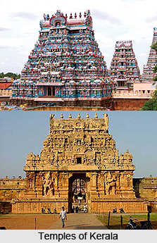
Temples of Alappuzha
Often referred to as the Venice of the East because of nature`s bounty Alappuzha houses a decent number of religious sites. Some of these temples are located amidst the backwaters while the others are famous for their architecture and antiquity.
Mullakkal Rajarajeshwari Temple: The Devi shrine is situated at the heart of this commercial centre, known for beautiful backwaters. The festivals of Navaratri (Sept-Oct) and Thaipuyakavadi (Jan-Feb) are celebrated here with lot of pomp.
Ambalapuzha: Once Bilvamangalam Swami and king Pooradam Thirunal of Champakasseri were sailing in a boat. They heard the melodious strains of a flute coming from an Ashwatha tree. The Swami knew that it was the music of Lord Balagopala (venu ganam), and they decided to build a temple at the spot. At the time of consecration, a defect was found on the idol and the king and the devotees were greatly disappointed. Following the Swami`s advice, they brought an idol of Parthasarathi from Kuruchi village secretly and consecrated it at the new shrine. This event, which took place in 1613 AD, is commemorated as a boat race during Onam. The Lord is worshipped as Unnikrishna. He is seen holding a whip in the right hand and Shanku in the left hand.

Paal Paayasam (milk porridge), the noon Neivedyam for the Lord, is very popular among devotees. The 10 days festival during March-April is attended by pilgrims with lot of enthusiasm. On the ninth day, the Natakasala sadhya (feast) is conducted in honour of traditional percussion instrument artistes.
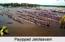
Haripad: Parasurama had installed Lord Subramanya in this shrine. The idol is known to have been later obtained from a river. The Pratishta ceremony is celebrated as Payipad Boat Race.
Mannarsala: Snake worship has been popular in Kerala from time immemorial. Many houses have small shrines dedicated to the serpent God, known as Sarpakavu. The temple in Mannarsala, situated in a grove, enshrines Nagaraja and His consort Nagalakshmi or Sarpayakshi. Thousands of stone Naga images are found in the grove.
Uruli Kamizhthal is a unique worship performed by childless couples. When blessed with a child, they visit the temple again and put the vessel back in its right position. Monthly Shivaratri and Ayilyam (Aslesha) star days are auspicious.
Chengannur Bhagavathi Temple: Chengannur is situated on the banks of river Pampa. Though the temple here is dedicated to Shiva and Parvati, it is better known as Bhagavathi shrine. Legends say that sage Agastya had his ashram on the hillside here. Shiva and Parvati, after their marriage at Mount Kailash, came to visit the sage, who could not attend the divine wedding.
Aaraattu and Thiruputtu festival take place. During these ceremonies the image is taken in a procession to river Pampa for the ritual. The devotees consider it auspicious to witness this event. Chengannur is also revered as one of the 51 Shakti Peetas, where a part of Sati`s body fell after the Daksha Yaga.

Aranmula: Lord Krishna is depicted as Parthasarathi, the divine charioteer, holding His Sudarsana Chakra. He is seen in a rare mood as he was in the Kurukshetra battle. The image was installed by Arjuna at Nilakkal on the banks of Pampa when the Pandavas were on a pilgrimage. The image was later shifted to this place in a shaft made of six bamboos. Hence the name Aranmula (Aru means six and mula means bamboo).
The temple is considered one of the sacred 108 Tirupatis. It is also one of the five famous Krishna shrines of Kerala, the other four being Guruvayur, Trichambaram, Thiruvarpu and Ambalapuzha. Aranmula boat race is held in honour of the installation of Lord Parthasarathi on the last day of Onam celebrations (Aug-Sept), known as Uthirattathi.
Vallasadya feast is held during Onam festivities with Vallomkali boat race. This commemorates an incident in which the Lord appeared before a pious Namboodri as an Athithi. A boatful of foodstuff (Thiruvona Chelavu Thoni) is still carried from nearby Kattoor village to Aranmula on this occasion.
Thiruvalla: Sri Vallabha (Vishnu) temple is situated 3 km from the station. A 50 foot tall granite flag staff with a Garuda image on top of it adorns the temple.
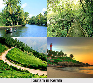
Tourism in Alappuzha
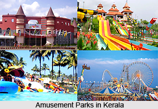
With the recent development of the tourism industry of Alappuzha, the place has become the tourist`s haven laced with its picturesque surroundings. The tourists can go on sailing on a houseboat that is on kettuvallam or catch a glimpse of the countrified lifestyle of the people. The view of the countryside is at its best with the vibrant villages that will fall on the way. Get greeted the place by flocks of ducks. Any one can watch the entire process of coir making in this land that is full of coconut canopies and be enthralled by the magic of the rich greenery all over the place. Some of the famous tourist places are Pathiramanal, Karumadikuttan, Kumarakodi, Krishnapuram Palace, Saradha Mandiram, Alappuzha Beach, Sea View park, Vijay beach park, etc.
According to history Alapuzha had trade relations with ancient Greece and Rome in B.C and in the Middle Ages. For example, Purakkad an ancient port near Alappuzha was Barace for them. From past onwards people from different religions such as Gujratis, Parsur, Mamens and Anglo Indians came at this place and built churches, mosques and temples respectively all of which has architectural magnificence. Such sites are worth beholding. Tourism in Alappuzha is therefore a flourishing industry with a number of resorts all over the place, which cater to the needs of the growing tourism sector.
Following are the name of some of the places of interest:
Pathiramanal:
This little island which is popularly known as `sands of midnight` on the backwaters is a favorite visit of hundred of rare migratory birds from different parts of the world. The island lies between Thaneermukkom and Kumarakom, and is accessible only by boat. There is one mythological story behind the naming of the place. This can be said as once upon a time a young Brahmin plunged into the Vembanadu lake to perform his evening washings and the water made way for land to rise from below, thus creating the attracting island of Pathiramanal.

R-Block:
This is mainly described as broad areas of Land have been altered from the backwaters and are protected by dams built all around. Here cultivation and habitation are made possible four to ten feet below Sea Level. These regions stand as the insignia of the wonderful agricultural engineering of Kerela while reminding the tourists of the legendary "dikes of Holland".
Karumadikuttan:
This is an 11th century statue of Lord Buddha. Many fascinating legends are associated with this statue that attracts a lot of tourists from across the world.

Kumarakodi:
It is a place situated at 20 km south of Alappuzha where Mahakavi Kumaranasan, who was said to be P.B Shelly of Malayalam Literature is buried. He brought great changes in literature and tried in changing the society also.
Krishnapuram Palace:
Dating back to the 18th century this place was built by Marthandavarma, which is famous for its mural or wall painting depicting the story of Gajendramoksham. It is situated at karthikappally in Kayamkulam. This exquisite piece of art is one of the largest murals in Kerala. There are many antique sculptures, paintings and bronzes present in this palace.
Saradha Mandiram, Mavelikkara:
A.R Rajaraja Varma WHO was a great poet and grammarian built Saradha Mandiram as his residence. This place is now bought by the State Govt and is kept as his remembrance.
Alappuzha Beach:
This beach is one of the most popular picnic spots in Alappuzha. The dock is over 137 years old and extends into the sea. Entertainment facilities at the Vijaya Beach Park add to the attractions of the beach. Another attraction for the tourists is the old lighthouse, which is greatly fascinating to them.
Sea View park:
This park is a famous place of the district and offers boating facilities and a swimming pool.
Vijay beach park:
This is mainly a picnic spot with children`s park & boating facilities.
The main attractions of the wayside are:
Chinese fishing nets, coir making, vast paddy fields, typical Nalukettu Kerala houses and every thing else that make Kerala unique.
Villages of Alappuzha
There are three taluks in Alappuzha- Cherthala Taluk, Ambalapuzha Taluk and the Kuttanad Taluk. There are twenty districts under these taluks.
CherthalaTaluk: There are twenty districts under this taluk. The municipality has been started since 1953. The taluk has a large area covering 320.44 Sq.Km and population is 4.78 lakhs. Sex ration in this taluk is 1030. Rural population is at least 2.79 lakhs that means density of rural population is 1465 persons per Sq.Km. Out of the 13 villages 2 are partly included in the municipality. Urban population is almost 32.54% and lowest urban density is 1530. Some of the important places of this taluk are given below:
Aroor:
Aroor is situated on the National Highway 47 between Cherthala and Kochi. Till 1960 there was no bridge. Only rafts had to be used for transporting vehicles although now there are many bridges connecting Aroor to Eda Kochi, one Rail Bridge is also there. One of the three industrial estates of this district is located here. It is also known as the one of the fish landing centres of the district.
Arthungal:
Located in Cherthala south village it is an important pilgrim centre of Christians and is famous for well-known St.Andrews Church, which was popularly known as St.Sebastuian Church. It is situated 8 Km southwest of Cherthala town facing the seacoast. Hindu pilgrims from Sabarimala used to visit Arthungal and take bath in a tank in the Church premises to formally conclude their forfeit. Though now the tank is not there.
Cherthala:
The town is famous for the well-known Devi Katthyayani temple located in the centre of the town. The image of Bhagavathy is said to have been set apart by Vilwamangalath Swamiyar. Being well connected by road and rail Cherthala is a major centre of coir industry. In Cherthala padayani and vela thullal are famous.
Kanichukulangara:
It is situated at 13 Km north of Alappuzha. Kanichukulangara is famous for the Bhagavathy temple. It is believed that a Brahmin who happened to recognize Devi who had reached the shore sanctified the place of worship. The souls of the Brahmin and the maiden who is said to have fallen in love with Brahmin have been consecrated in small shrines inside the temple.

Kokkothamangalam:
It is situated on the western shore of Vembanad lake. It is the place of one of the two churches in Arch Diocese of Ernakulam. It is said that the apostle St. Thomas, who visited Kerala and established 7 churches there also consecrated a cross here in this district. Later the cross was missing for a long time and it was again recovered from Pallipuram and brought back to Kokkothamangalm where a church was built. The present church was built in 1900.
Pathiramanal
Pathiramanal, popularly known as the mysterious sand of midnight is a small beautiful island of tourist importance. This island is full of coconut trees and luxuriant vegetation and is situated in the centre of Vembanad Lake, 4 Km east of Muhamma. Thannermukkom
It is situated on the western bank of Vembanad Lake. The Thannermukkom salt-water barrier was constructed as a part of Kuttanad Development Scheme. The Thannermukkom regulator built across Vembanad Lake between Thannermukkom and Vechur is mainly to prevent tidal action and intrusion of salt water. It is actually the largest mud regulator in India.
Thiruvizha
Thiruvizha is situated about 5 Km southwest of Cherthala and is famous for its Shiva temple. The temple attracts large number of devotees on account of the divine prasadam, which is supposed to possess medicinal and curative properties for mental illness.
Vayalar
It is situated about 2.5 Km north of Cherthala. Vayalar is a politically important place in the history of modern Kerala. The historic struggle at Vayalar, which took place by the communist party against Sir C.P. Ramaswamy Iyer, Diwan of Travancore, resulted in the relinquishment of the rule of Diwan. As a result hundreds of communists fell victim to the tragic police firing in 1946. There is a martyrs` platform or Raktha Sakshi Mandapam erected at this place.
Ambalapuzha Taluk: There are mainly thirteen villages under this Ambalapuzha taluk. Its total area is 67.81 Sq. Km. It is mainly on the second position in population with 4.08 lakhs. The lowest rate of rural population in the district is 1.18 lakhs while most thickly populated area is having density with 1738 persons per sq. km. The total population is 117826 out of which 58099 are males and 59727 are females. Sex ratios of the district are 1038. The lowest percentage of rural area in the district is with 37.92 %, whereas urban population is more in the district with about 2.90 lakhs, which works out to be 47.56% of the total urban population of the district. This district has the second rank in urban density, which is 2612, and in the second position in highest growth rate that is 8.59%.
Some of the important places are as follows:
Alappuzha:
It is situated at 157 Km north of Thiruvananthapuram, which is the capital of Kerala state, and 62 Km south of Kochi on the National Highway-47. Alappuzha, which is the head quarters of both the district and the taluk is an important commercial town. The then diwan of Travancore, Raja Kesava Das founded the town in 1762. He has a view to make the place a commercial centre. Surrounded by the sea and backwaters and the canals intersecting it, Alappuzha is often referred as `the Venice of East`. The banks of these canals are the centres of many industrial and commercial establishments, particularly coir, copra, timber etc. From time behind, Alappuzha was the chief depot for sale of forest and other products. The port was opened in 1962 and canals were constructed to link the port to make commercial contacts with the interior.
In the 19th century, Velu Thampi Dalawa took keen interest in constructing road, and markets, which were later, improved by Rani Parvathi Bai. A lighthouse that is visible from a distance of 26 Km was built in 1862. For the passage of cargo nearly 1000 ft. long pier was built. Though the port has lost its maritime importance due to the nearness of Kochi port. The town still remains to be an important commercial and industrial centre of production and also supplier or coir yarn and coir products. The first modern factory for the manufacture of coir mats and matting was started here in 1859. The first post and telegraph office of the princely state of Travancore was established in Alappuzha when postal communicator was introduced in Travancore in1857.
It is the centre of a large network of inland water transport services. Well-maintained beaches are there. Among the churches The Holy Cross church established in 1400 and the Mount carmel Cathedral in 1809 are the significant one. The only one Jain temple of Travancore area is also located here.
A colourful water carnival, the Nehru Trophy Boat race, which was named after Pandit Jawaharlal Nehru to commemorate his first visit to the district, is conducted on 2nd Saturday of August every year at Punnamada Kayal or Vatta Kayal about half a Km east of town.
Ambalapuzha:
Ambalapuzha was formerly known as capital of Chempakasseri Rajas and is located about 13 Km south of Alappuzha. The place is connected with road, rail and canal. Ambalapuzha is famous for the well-known Sree Krishna Swamy temple. The architecture of the temple conforms to the typical Kerala style. Ambalapuzha `Palpayasam`, made of rice and milk, which is an important offering to this deity, still retains its flavour and sweetness. Ambalapuzha temple is closely associated with the introduction of Ottamthullal by Kunjan Nambiar.
Karumadi:
Karumadi is a quiet village in Ambalapuzha taluk surrounded by brackish water and fertile paddy fields. The place is famous for the black granite Budha temple, popularly known as `Karumadi Kuttan`, which is standing by the side of the public canal. In 1965, Kerala Government declared this temple as protected monument and the State Archaeological Department has taken the control over it.
Punnapra:
This place is situated very close to Alappuzha Municipality on Alappuzha-Kayamkulam road and now treated as an urban outgrowth of the city. As in case of Vayalar, this place is famous for the historic communist struggle in 1946 against the then Diwan of Travancore Sir C.P. Ramaswamy Iyer. The police firing that resulted in indiscriminate firing and deaths of hundreds of people. This agitation led to the termination of the rule of the Diwan.
Purakkad:
Purakkad, whose literally meaning is `out of forest` mainly is a coastal village of Ambalapuzha Taluk. This is situated on National Highway 47 about 17 Km south of Alappuzha. The place has some historical significance, as it was the area of battle between Travancore and Kochin forces in 1754 AD and between Travancore and the forces of Zamorin in 1756 AD. There was an ancient port at Purakkad. The Dutch East India Company had a factory at that time. In the 16th Century Portuguese built a church at Purakkad. An interesting phenomenon in this seacoast is the Chakara, which is of great marine importance. Particular varieties of fish accumulate in the mud bank making it very easy for fishermen to have bountiful catch. Many fishermen of this region have converted to Christianity when St. Francis Xavier had visited this place during the 16th century.
Thottappally:
Thottappally, which lies in the vicinity of Purakkad, was the scene of battle between Travancore forces and army of Chempakassery Raja. Thus it has become the place of strategic importance. Now the place is well known for the spillway across the Vembanad Lake. The national Highway 47 passes over this spillway, which was constructed in 1954 to divert the floodwater of Kuttanad into the sea and also to prevent salinisation of fresh water.