 Rihand project is the most important multi-purpose project in Uttar Pradesh. It is located in the borders of Uttar Pradesh and Madhya Pradesh. The Rihand River flows across a narrow gorge in the Vindhyan ranges in the Mirzapur district of Uttar Pradesh. It may appear lazy and docile in the dry season but during the monsoons it is a very strong and vicious river. The river originates in the Manipal Hills in Madhya Pradesh and goes through its course up to Pipri. The dam site and the river hoard large amounts of water. Moreover, it has a steep fall of 730 meters which is of tremendous natural advantage for Hydel-power.
Construction of Rihand Project
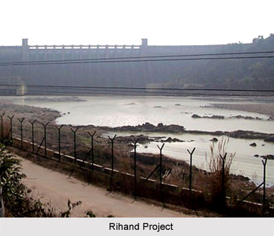
The Rihand dam has been built across Rihand River near Pipri in the Sonbhadra district of Uttar Pradesh. The project was completed around the year 1962. It consists of a concrete dam located at about 46 km to the south of the meeting point of the Rihand and the Son rivers. It is 934 meters in length and 91 meters in height. The dam has 61 independent ground and joint blocks. The reservoir behind this dam, known as Govind Ballabh Pant Sagar extends over an area of 466 square km. The water stored behind the Rihand damis released into the river Son, giving it supplies for irrigation throughout the whole year in the eastern regions of Uttar Pradesh, providing them with additional irrigational facilities of 2 lakh hectares.
The power house at the foot of the dam has six generating units each with an installed capacity of 50 MW. A dense network of 132 KV and 66 KV transmission lines with the required sub-station runs through the entire eastern and south- eastern parts of Uttar Pradesh. The power system provides electricity to cottage industries, medium industries and major industries. Apart from these, power is also supplied to over 2500 tube wells irrigating an area of 5 lakh hectares in Faizabad, Gonda, Mirzapur, Gorakhpur, Deoria, Ballia, Varanasi, Ghazipur, Azamgarh, Jaunpur, Rai Bareilly, Allahabad and some other districts of Uttar Pradesh.
Purpose of Rihand Project
The main aim of the Rihand Project is to generate hydro electric power. This project is a great boon to the aluminium industry at Renukoot, the chemical industry at Pipri, the Cement Industry at Churk and other industries like fertiliser, porcelain and paper. The Rihand Project also provides benefits for the development of fisheries, navigation, flood control in the Rihand and Son rivers. Among its other benefits forestation, water sports and tourism may also be considered.


