 Mirzapur District, an administrative district of Uttar Pradesh, forms a portion of Varanasi Division. It has its headquarters located at Mirzapur town. This district lies between the parallels of 23 degree 52 minutes and 25 degree 32 minutes north latitude and 82 degree 7 minutes and 83 degree 33 minutes east longitude. On the north and north-east, it is bounded by Varanasi District; on the south it is bounded by district Sonbhadra. On the south west it is bounded by the district of Allahabad. The shape of the district towards the north and west is somewhat irregular. According to Census 2001, total population of Mirzapur District is 1657140 (male population is 1093849 and female population is 980860) of which 1788203 were living in rural and 286506 in the urban area of the district. Mirzapur District occupies a total area of 4521 sq kms.
History of Mirzapur District
According to the tradition, the name of this town, after which the District itself is named, was Girzapur, which in terms derives its name from Parvati (Girija). Mirza, Vindhyavasini and Laxmi are the other names of the goddess whose temple exists at Vindhyachal. The present name of the district is derived from Goddess Laxmi who emerged from the sea. The word Mirza is formed from two words; `Mir` meaning sea and `za` meaning outcome. It is also locally believed that the town was founded by Raja Nanner and was known as Girijapur, but later on it came to be known as Mirzapur.
Mirzapur District falls entirely within the tract of country once known as the province of Banaras. The sovereignty of this district was formally ceded to the East India Company in 1775 by the Nawab of Awadh; but the tract itself was included in the zamindari of the Raja of Banaras and remained in his actual possession until 1794. It is not until 1830 that Mirzapur became a separate revenue jurisdiction of its own, because until that year it had been included in Varanasi. There has been no change in the territorial limits of Mirzapur since 1833, revenue and judicial administrations were made to coincide throughout the province of Banaras; but several alternations have been made in the sub-divisional boundaries since the tract came into the possession of the British. In 1801 every Pargana had a separate Tehsildar. In 1804, it was resolved to abolish the office of Tehsildar in Banaras province.
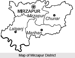
Administration of Mirzapur District
At present Mirzapur District has four tehsils, namely Sadar (Mirzapur), Chunar, Marihan and Lalganj from administrative point of view. Further, administration of Mirzapur District has 12 development blocks and 15 police stations, which are Mirzapur (City), Kon, Chhanbey, Majhwan, Pahari, Sikhar, Narayanpur, Jamalpur, Marihan, Rajgarh, Halia and Lalganj. District Magistrate is the head of the district administration.
Mirzapur District is known for its several historically acknowledged sites that attract travellers from distant places.


