 The Great Indian Peninsular Plateau, alternatively known as the Plateau of the Peninsular India, is a vast plateau, comprising most of the southern part of the country. The plateau rises 100 m in the north, and stretches over 1 km in the south, forming an elevated triangle nestled in the renowned downward-moving triangle of the coastline of the Indian subcontinent. The Great Indian Peninsular Plateau stretches to the south of the alluvial plains of the Northern India forming a large triangle with its apex in the south at Cape Comorin. The Great Indian Peninsular Plateau is formed essentially of the ancient igneous rocks. The earth movements which have brought some changes in the landscape of this stale block of the earth`s crust were vertical, thus, resulting in the formation of faults along which some areas sank forming faulted basins or rift valleys.
During the Gondwana period, when drainage of the neighbouring area flowed into these basins, deposited clays and sandstones and turned them into swamps. The position of the Gondwana rocks is roughly marked by the valleys of the Damodar River, Godavari River and Mahanadi River.
Geography of Great Indian Peninsular Plateau
Malwa Plateau is drained to the north and is formed by horizontally bedded sandstones and limestones that were laid down during the earlier Gondwana period. During this period, the Malwa Plateau was submerged under the sea. South of the Satpura Mountain Range, the peninsula is named the Deccan Plateau. After examining the young and folded mountains of the north and much younger plains to their south, one can move down further south to the oldest structure of the Indian subcontinent. As a matter of fact, the slow but stable progress of this landmass (tectonic plates) towards north and north-east is accountable for the construction of the Himalayas and the Northern Plains. The peninsular plateau is further split up into the Central Highlands in India and the Deccan Plateau.
Central Highlands
The northern part of the peninsular block is called the Central highlands, the block comprises two parts, delimited by the west-flowing Narmada. Vindhyas and its eastern elongations border the one lying to the north on one side though they are not truly towering. It is created from solid igneous and metamorphic rocks. Towards the north-west it is lined by the Aravallis. The plateau stretches further to the west, but is cut across by the sandy and rocky deserts of Rajasthan. These are pretty old fold mountains. On the third side, this plateau unites progressively with the Indo-Gangetic Plains of the north. This is known as the Malwa Plateau; reasonably wide in the west and becomes tapered in the east. The eastern part is known as Bundelkhand and Baghelkhand in southern Uttar Pradesh. In south Bihar it is called Chota Nagpur Plateau. The southern tributaries of the Yamuna River and Ganga River irrigate the plateau.
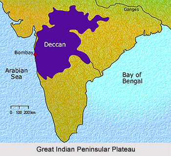
Deccan Plateau
The Peninsular plateau also known as the Deccan plateau is a raised flat landscape located on west-central India, was created by the eruption and solidification of magma over an extended epoch. The word Deccan is derived from Sanskrit Language Daksina or Dakkhin in Prakrit, which means south. The Deccan Plateau, In the Deccan Plateau, such magma deposits are around 1000 meters thick. Situated amidst the Western Ghats, which constitutes its western frontier, and the Eastern Ghats forming its eastern frontier, the Deccan Plateau stretches from the Vindhyas to the southern tip of the peninsula. This triangular plateau is at its broadest in the north. The Vindhya Mountain Range and its eastern elongations viz. Mahadev Hills, Kaimur Hills and Maikal Range form its northern edge. Towards the west, the plateau has pretty exorbitant edge, formed by the Western Ghats. This mountain range runs from north to south, nearly parallel to the Arabian Sea. The Western Ghats are recognised by various local names. In Maharashtra and Karnataka they are called Sahyadri. Down south, they are called the Nilgiris in Tamil Nadu. Still further south, along the Kerala and Tamil Nadu border, they are known as Annamalai and Cardamom Hills. The Deccan Plateau is the highest along its western periphery and lightly inclines towards the Bay of Bengal in the east. The Western Ghats are comparatively elevated in their southern part. Anai Mudi, the highest peak, is 2,695 m above sea level. Udagamandalam is a renowned hill station of the south, located in Tamil Nadu.
The Aravalli Range runs in the northeast-southwest direction from Delhi to the north-eastern fringe of Gujarat characterised by a chain of detached and discontinuous ridges running in the northeast-southwest direction between Delhi and Ajmer. The Narmada Valley is flanked by a steep sided escarpment of the Malwa Plateau in the north. The Satpura Mountain Range starting from the West Coastal Plain runs eastwards between the Narmada and the Tapti-Purna rivers. Its western extremity is known as the Rajpipla Hills and the easternmost part as the Amarkantak Plateau and in between as the Mahadev Hills. Steep sided plateaus of elevations varying from 600 to 900 m throughout the length are found in the Satpura Range.
Chhattisgarh Plain is a basin drained by the upper Mahanadi which lies to the east of the Maikala Range and is separated from the Wainganga Valley by low Khairagarh Plateau. North-eastern part of the Indian Plateau lying to the east of the Rihand River is the Chota Nagpur Plateau including the Bihar Plateau, the adjoining eastern fringe of Madhya Pradesh and Purulia District of West Bengal. The Ranchi Plateau in the south, the Hazaribagh Plateau in the north and the Rajmahal Hill in the north east constitute important physiographic sections of the Chota Nagpur Plateau. The Ranchi Plateau, is in fact a group of plateaus elevated to different heights, that lies to the south of the Damodar.. Interestingly, the Hazaribagh Plateau lies to the north of the Ranchi Plateau. Like the Ranchi Plateau, it too has isolated hills on its surface. Rajmahal Hills forming the north-eastern edge of the Chota Nagpur Plateau runs in the north-south direction.
Rocks of the Indian Peninsular Plateau re-appear in Meghalaya and form a rectangular block known as the Shillong-Plateau or the Meghalaya Plateau. This plateau has been separated from the main block of the Indian Plateau by a wide stretch of alluvial lowland called the Garo-Rajmahal Gap.
Other than the regions mentioned above, cities like Aurangabad, Nagpur, Hyderabad, Pune and Bengaluru are also situated in the Great Indian Peninsular Plateau. Rice, cotton and sugarcane which are the principle crops found here.


