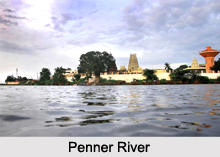
 The Penner River is located in the Indian state of Karnataka and is called the river of southern India. More specifically, this river basin is located in the rain shadow region of the Eastern Ghats in Chickballapur district. It is also known by several other names in Sanskrit such as Pennar, Penna, Penneru and Pinakini. The name of this river, Penneru (alternatively Penner) is known to be derived from Telugu words penu meaning grand and yeru meaning a river, a stream or a rivulet or else from neeru meaning water in flow.
Geography of Penner River
Globally, the Penner River can be pinpointed at coordinates 14 degrees 34 minutes 46 seconds north and 80 degrees 11 minutes 44 seconds east. This river has a length of about 597 km (371 mi). The area occupied by the river basin is about 55,213 km2 (21,318 sq mi). More specifically, this river is called an interstate river with 6,937 km2 river basin area located in Karnataka and 48,276 km2 river basin area located in Andhra Pradesh. The watershed of the Penna and its tributaries covers part of the southern Deccan plateau, including most of the Rayalaseema region of Andhra Pradesh and part of Karnataka. The Kolar Plateau forms the divide between the Penna watershed and those of the Kaveri, Ponnaiyar, and Palar rivers to the south. The Penna drains the northern portion of the plateau, which includes parts of Kolar and Tumkur districts in Karnataka. The Krishna River and its tributaries drain the Deccan plateau to the west and north of the Penna`s watershed, and the low Erramala hills forms the northern divide of the Penna basin. The upper watershed of the Penna includes Cuddapah District, central and eastern Anantapur District, the southern part of Kurnool District and northwestern Chittoor District.
The Penna basin has a dry tropical monsoon climate. The upper basin of the Penna is semi-arid, with summer temperatures ranging from 25 to 46 degree C and winter temperatures ranging from 18 to 28 degree C. The average annual rainfall received by the river basin is about 500 mm. The rain fall is predominantly received during the north east monsoon season. In the 1990s, the Penna basin was attacked by a prolonged drought, which adversely affected the farmers of the area. The construction of an aqueduct became a political demand post this disaster, in order to supply water from the Krishna River to Rayalaseema. The upper basin of the Penna River is largely made up of ancient Archean rocks, mainly granite and schist. Its lower basin is made up of young sediments, which comprise of laterite and recent alluvium.
Course of Penner River
The Penner River has its source and mouth in different locations. More specifically, its source is Nandi Hills, located in Chikkaballapur district of Karnataka. This river flows east through a gap in the Eastern Ghats ranges onto the plain of coastal Andhra. It then runs north and east through the state of Andhra Pradesh. The mouth of this river is located in Utukuru, 15 km east of Nellore in Andhra Pradesh. This river then drains itself into the Bay of Bengal.
Tributaries of Penner River
The Penner River has left tributaries as well as right tributaries. More specifically, the Jayamangali, Kunderu and Sagileru are the left tributaries of Penner River. The Chitravati, Papagni and Cheyyeru are the right tributaries of Penner River.
Estuary of Penna River
The estuary of the Penna River extends about 7 km upstream from the Bay of Bengal. In the dry season from November to June, the tidal influence and salt water extends further upstream. Coastal dunes can be found around the river mouth. They have a height of about 7 meters. The main coastal wetlands are formed by the Upputeru tidal creek and Isakapalli lagoon. The Upputeru tidal creek is known to be about 15 km in length. The Isakapalli lagoon is known to have a length of about 180 m, a height of about 3 m and is separated from the Bay of Bengal by the Isakapalli barrier island.
Flora around Penna River
Tropical dry forest, thorn forest and xeric shrublands earlier comprised the vegetation in the upper basin of the Penna River. Unfortunately, owing to the clearance of forests for grazing and over harvesting for timber and firewood, thorny shrublands have replaced the vegetation of the Penna River upper basin. The remnant forests of the Deccan are largely deciduous, dropping their leaves in the dry winter and spring months. The East Deccan dry evergreen forests of Coastal Andhra have largely been reduced to tiny remnant pockets and are no longer evergreen.
Utilization of Penner River
The Penner River has an average annual water yield of about 6.316 billion cubic meters. This river has water storage reservoirs of nearly 5 billion cubic meters capacity. These reservoirs are utilized to harness all the water sources in the river basin. Ground water is also extensively harnessed in the river basin beyond the long term sustainability. It is important to note that due to two reasons, transference of water has become a possibility from the adjoining Krishna basin into Penna basin up to 600 m MSL elevation with moderate water pumping (less than 100 m head). These two reasons are the north east monsoon season being the predominant rainfall season for the Penner River, whereas the south west monsoon season is the season of rainfall for the adjoining Krishna river basin and the Penner River basin being located at a geographically lower elevation as compared to the surrounding Krishna River basin.
Thus, the monsoon flood waters of the Krishna River during south west monsoon season can be imported to the Penner River basin, which is a boon for the extensive rain fed agriculture lands and water storage sites of the Penna river basin. It is important to note that excess water of the Krishna River can be transferred for direct use in Penna basin without the need of water storage.
Development of Penner River
The future development of Penna River depends on interstate water sharing agreements of Krishna River. In this regard, it is important to note that the Penna basin water apportionment is governed by the colonial time water sharing agreement in the year 1892 and the Interstate River Water Disputes Act, 1956. The Tungabhadra Dam, which is located in Karnataka and is a joint project of Andhra Pradesh and Karnataka, will act as the only gateway for water transference (up to 600 m MSL) from the Krishna River to the uplands of Penna basin. The Srisailam dam will act as a gateway for water transference (up to 250 m MSL) from Krishna River to the low lands of Penna basin. The fate of Penna basin is also dependent on the results of ongoing Krishna Water Disputes Tribunal - II.
Literature related to Penner River
The Penna basin is credited with the growth of Telugu literature. Aadikavi Tikkana Somayajulu, Raallapalli Anantha Krishna Sharma, Vidvan Vishvam, and C. Ramakrishna Reddy are the examples of several well-known authors and poets, who have shaped Telugu literature. Penneti Paata meaning a song of River Penna is well known in Andhra Pradesh. It is written by Vidhwan Viswam. This song is a part of the curriculum of the graduation course of Telugu language in Raayala Seema. The tragic and cultural life of the people of Penna valley is described in penneti kathalu. This is also written by Vidhwan Viswam.
Other Places of Attraction near Penner River
Nandi hills, Arkavathy River, Vidurashwatha Temples, Nandi Archeology and Rangasthala Temples are the other places of attraction near Penner River.
Visiting Information
Since Penner River is located in Chickballapur, its transport system is of relevance to it. Nearest Airport to Chickballapur is in Bengaluru. As far as railways is concerned, it is important to note that Chickballapur itself has railway station.
Related Articles:
Water Resources in India
Indian Rivers
Himalayan Rivers
Coastal Rivers
Narmada River


