
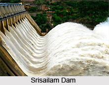
 The Srisailam Dam is an important Dam project in the state of Andhra Pradesh across the Krishna River at Srisailam in the Kurnool district. The Srisailam Dam is one of the 12 largest hydroelectric projects in the country. The dam is built in a deep gorge in the Nallamala hills, which is 300 m or 980 feet above sea level. The Srisailam Dam is 512 m or 1,680 feet long, 240.79 m or 790.0 feet high and features 12 radial crest gates.
Providing irrigational water for about 800 square kilometers or 310 square miles in Kurnool District and Cuddapah District, the Srisailam Dam is a prime source of water in the drought-prone region of Rayalaseema. Special permission is needed for the tourists to go on to the main dam. The Srisailam town is located 232 km south of Hyderabad.
The construction of Srisailam Dam had begun in the year 1960 across Krishna River in a place called Srisailam in Andhra Pradesh. Initially it had started as a power project and the construction of the project had completed in the year 1981. By the year 1987 the dam had been made into a multipurpose project with a generating capacity of 770 MW. It is estimated that the dam waters an area equal to 4, 95,000 acres. The water of the dam has a spread of 238 miles. Due to the right branch of the canal the water flow to Kurnool District and Cuddapah District are forever assured.
As a hydro-electric power project was constructed across the dam around 102 villages in the Kurnool and Mahboobnagar District located along the banks of River Krishna, Tungabhadra River and Bhavnasi were submerged and many people had lost their habitation. On 2nd of October, 2009, the Srisailam recorded such an inflow that the existence of the dam itself came under severe threat.
Places of interest at close proximity of the Srisailam Dam include Bhramaramba Mallikarjunaswamy Temple on the hill range of Nallamala Forest, Sikhareswara Swamy Temple and Sri Ganapathi temple. The nearest railway station is Nandyal on Guntur-Hubli broad gauge line, which lies about 158 km from the Srisailam Dam.









