Home > Indian History > Geography of India > Mountain Peaks of North India
Mountain Peaks of North India
Mountain Peaks of North India have not only beautified this region, but have also contributed in making North India a tourist destination.

Share this Article:

Mountain Peaks of North IndiaThe states of Uttarakhand, Jammu and Kashmir, Himachal Pradesh, Uttar Pradesh and Haryana are located in the northern part of India. North India has several mountain peaks existing as a part of its geographical terrain. They have not only beautified the states in North India, but have also contributed in making this region a tourist destination of India.

Mountain Peaks of Uttarakhand
Nanda Devi of Garhwal Himalaya is known to be the highest point of Uttarakhand. It has a height of about 7,816m (25,646ft). Some of the other mountain peaks beautifying Uttarakhand are Abi Gamin (7,355m/24,131ft), Arwa Crest (6,250m/20,505ft), Barmatia (6,041m/19,820ft), Changuch (6,322m/20,741ft), Devtoli (6,788m/ 22,270ft), Hathi Parbat (6,727m /22,070ft), Nanda Ghunti (6,309m/20,699ft) Kamet (25,446 ft / 7,756 m), Nilkantha (21,640 ft / 6,596 m), Yogeshwar (6,678m/21,909 ft), Nanda Pal (6,306m/20,689ft), Sangthang (6,480m/ 21,260ft), Suj Tilla West (6,333m/20,778ft), Suj Tilla East (6,373m/20,909ft), Thalay Sagar (6,904m/22,651ft), Trimukhi Parbat (6,422m/ 21,070 ft), Uja Tirche (6,204m /20,354ft ),Vasuki Parbat (6,792m/ 22,283ft) and Telkot (6,102m/20,020 ft).Mountain Peaks of North India

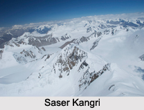
Mountain Peaks of Jammu and Kashmir
Saser Kangri is the highest mountain in Kashmir and the 4th highest mountain in India. It has a height of about 25,171 ft (7,672 m). Some of the other mountain peaks of Jammu and Kashmir are Nunkun (20,924 ft / 6,378 m), Stok Kangri (20,187 ft / 6,153 m), Kolahoi (15,768 ft / 4,806 m), Sire Chhish (15,476 ft / 4,717 m), Gutumishungi Chhish (15,220 ft / 4,639 m), Bardum (14,892 ft / 4,539 m), Nichinai (14,643 ft / 4,463 m) and Shin Mahinyu (14,529 ft / 4,429 m), Chinamarg (13,812 ft / 4,210 m), Nurpur Neza (13,832 ft / 4,216 m), Biamocheni Gob (13,854 ft / 4,223 m) and Haramukh (13,879 ft / 4,231 m).

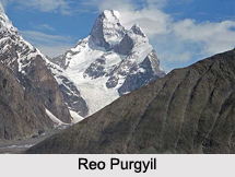
Mountain Peaks of Himachal Pradesh
Reo Purgyil is the highest mountain in Himachal Pradesh and has a height of about 6,816 m. Some of the other mountain peaks of Himachal Pradesh are Manirang (6,597m), Jorkanden (6,473m), Papsura (6,440m), Dibibokri Pyramid (6,400m), Gang Chua (6,288m), Mukar Beh (6,070m), Shipki(6,068m), Sanakdeik Jot (6,045m), Deo Tibba (6,001m), Pir Panjal (5,972m) and Hanuman Tibba (5,860m).

Mountain Peaks of Uttar Pradesh
The state of Uttar Pradesh is beautified by Nagonath, which has an elevation of about 168 meters (551.2 feet).

Mountain Peaks of Haryana
Karoh Peak is the highest mountain peak in Haryana. It has a height of about 1,499m (4,918ft). Some of other mountain peaks of Haryana are Samlasan Devi (2,585 ft / 788 m), Bansgati No 2 (2,552 ft / 778 m) and Khudana (1,564 ft / 477 m).


Share this Article:

Related Articles

More Articles in Geography of India


Geography of Uttar Pradesh
The fourth largest State in India UP is located in the Northern part of India whose area is 2,36,286 sq Kms.
Geography of Maharashtra
Covering an area of 308,000 sq. km, Maharashtra, the third largest state in India.
Geography of Kerala
Geography of Kerala includes plains, hills, valleys and coasts. With the Arabian Sea in the west, the Western Ghats in the east and networked by several rivers, Kerala enjoys diverse geographical features.
Geography of West Bengal
The geography of West Bengal is unique with high peaks of the Himalayan range in the north, the Bay of Bengal in the south and the remaining region is covered with both plains and plateaus.
Geography of Jharkhand
Geography of Jharkhand is comprised of the rich mineral resources and the highly agricultural prospect in this state.
Geography of Sikkim
Geography of Sikkim is characterised by a vast array of magnificent hillock that extends from one corner of the state to the other.
Geography of Meghalaya
The suitable climate, highland plateaus, rivers and the flora and fauna together forms the geography of Meghalaya.
Geography of Mizoram
Mizoram is surrounded by hills, valleys, rivers, waterfalls and lakes. The hills range from 1000 meters to 2000 meters. Rivers, lakes and waterfalls also play major role in forming the land of Mizoram.
Geography of Jammu & Kashmir
Jammu and Kashmir is encompassed by valleys. Some of the dominant valleys of the state are Kashmir Valley, Tawi Valley, Chenab Valley, Poonch Valley, Sind Valley and Lidder Valley etc. Jhelum River is the only major Himalayan River which flows through the Kashmir valley. Indus, Tawi, Ravi and Chenab Rivers are the major ones flowing through the region.
Geography of Daman and Diu
Daman and Diu is situated on the west coast of India and are the smallest union territories of India.
Geography of Goa
Geography of Goa occupies a prime location along the Konkan coastal belt on the western coast of India. The state is bordered by Maharashtra in the north and Karnataka in the south. The Western Ghats in the east contribute to the flora and fauna of Goa.
Geography of Arunachal Pradesh
Geography of Arunachal Pradesh reveals that it is a hilly tract nestled in the foot of Himalayas.
Geography of Kutch
Geography of Kutch District is covering an area of 45,612 km. Kutch District is the largest district in the state of Gujarat.
Geography of Ladakh
Geography of Ladakh mainly comprises the huge Karakoram Range with long stretch of cold desert which mark the region separately from the rest of the states of Indian subcontinent. Surrounded with the mountain ranges from all corners this small region separates Indian subcontinent from rest of the Asian continent.
Geography of Rajasthan
Geography of Rajasthan defines the dry topography with arid climate of the western mountain region.
Geography of Tamil Nadu
The Indian state of Tamil Nadu is located in the Northern hemisphere in the hot zone.