
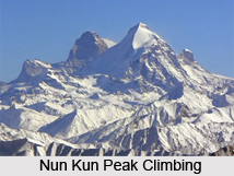
 The Nun Kun mountain massif consists of a pair of Himalayan peaks, namely Nun, 7,135 m (23,409 ft) and its neighbor peak Kun, 7,077 m (23,218 ft). Nun is the highest peak in the part of the Himalayan range lying on the Indian side of the Line of Control in Jammu and Kashmir. There are comparatively the higher peaks in the Indian part of the Karakoram Range. The massif is located near the Suru valley, about 100 km (60 mi) east of Srinagar, the capital of Kashmir.
Kun Peak is located north of Nun and is separated from it by a snowy plateau of about 4 km (2.5 mi) in length. Pinnacle Peak, 6,930 m (22,736 ft), is the third highest peak in the group. Mountaineering is a common activity in the Nun Kun Peak. Early exploration of the Nun Kun peaks included a visit in 1898 and three visits by Arthur Neve, in 1902, 1904, and 1910. In 1903, Dutch mountaineer Dr. H. Sillem investigated the Nun Kun peaks and discovered the high plateau between the peaks; he reached an altitude of 6,400 m (21,000 ft) on Nun. In 1906, noted explorer couple William Hunter Workman and Fanny Bullock Workman claimed an ascent of Pinnacle Peak. They also toured extensively through the Nun Kun peaks and created a map; however, controversy surrounded the Workmans` claims, and few trigonometrical points were given for the region, so that the map they produced was not convenient to be used.
After unsuccessful attempts to climb the Nun Kun peaks in 1934 and 1937, the first ascent of Nun was in 1953 by a French-Swiss-Indian-Sherpa team supervised by Bernard Pierre and Pierre Vittoz, across the west ridge. The Nun Kun peak succession pair comprised Vittoz, a Moravian missionary to the Tibetans and an experienced alpinist, and Claude Kogan, a pioneering female mountaineer. Since then, other routes have been pioneered. Six climbers first ascended the northwest face in 1977 from a Czech expedition. Italian mountaineer Mario Piacenza made the first ascent of Kun in 1913, via the northeast ridge. Fifty-eight years passed before the second recorded attempt on the Nun Kun peaks, which resulted in a triumphant ascent by an expedition from the Indian Army. The massif is most conveniently accessed from the road connecting Kargil and Leh.









