 The state of Odisha is located in the eastern part of India. The geographical terrain of this state is characterized by mountain ranges, valleys, plateaus, rolling uplands, rivers, lakes, beaches and plains with fertile silt deposits. These, along with temples based on Indo Aryan Nagara style of architecture, Buddhist and Jain pilgrimage centers, national parks, hill station, etc have not only beautified this state, but also draw a number of tourists. To reach Odisha, international as well as domestic airports have been established in the state.
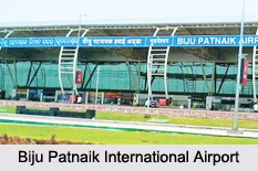
Biju Patnaik International Airport
Biju Patnaik International Airport is located in the city of Bhubaneswar. It is regarded as the only international airport in Odisha. This airport which is operated by Airports Authority of India was opened on 17th of April, 1962. Its eco friendly domestic terminal can accommodate about 4 million passengers per year and was built by Lanco Infratech (Octamec). This airport also has an international terminal, which takes care of the international flights from the airport.
Jeypore Airport
Established in the year 1962, Jeypore Airport is located about 3 km north-west of the town of Jeypore. This public airport is owned by the Airports Authority of India and operated by the Public Works Department. It is known to spread over 60 acres of land.
Savitri Jindal Airport
Named after the richest lady of India namely Savitri Jindal, Savitri Jindal Airport is located in a place called Angul in Angul district. This airport is owned by Jindal Steel and Power and operates as a public and private airport. This airport has one paved runway with asphalt surface.
Kendujhar Airstrip
Kendujhar Airstrip is located in Gopinathpur in the district of Kendujhar. This airport is owned by the Government of Odisha and serves Kendujhar as a private and public airstrip. This airport has one paved runway with asphalt surface.
Barbil Tonto Aerodrome
Barbil Tonto Aerodrome is located in Barbil in the district of Kendujhar. This airstrip is owned by Jindal Steel and Power and operates as a private and public airstrip.
Rourkela Airport
Rourkela Airport is located near Chhend Colony, 6 kilometers west of the city of Rourkela. Steel Authority of India Limited is its operator. It is the only airport of the metropolitan area of Rourkela city. This is a private airport fulfilling the transportation needs of the dignitaries and VIPs visiting Rourkela, especially officials of Steel Authority of India Limited (SAIL).
Other Airports in Odisha
Hirakud Airstrip, Lanjigarh Airstrip, Phulbani Airstrip, Berhampur Airport, Nawapara Airport, Nuagaon Airstrip and Utkela Airstrip are some of the other Airports in Odisha.