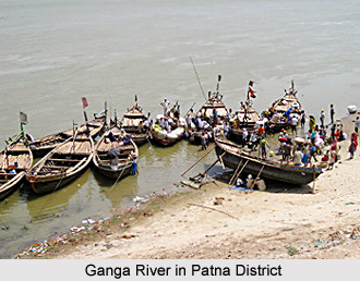
 Patna District is one of the administrative districts of Bihar. Patna is the largest town and headquarters of Patna District. It is also the capital city of the state. It is mainly an administrative and educational centre. It has however a few ancient sacred places as also places of tourist interest. Patna District lies virtually in the heart of the south Bihar plain. Patna District is bounded on the north by Ganga River, beyond which lie the districts of Saran District, Vaishali District, Samastipur District and Begusarai District. To the east, it is bounded by Lakhisarai District and Nalanda district and in the south the district of Jahanabad. Patna is separated from Bhojpur District on its west by Son River. Total area of the district is 3202 sq km.
History of Patna District
The district is named after its principal city, Patna. Various legends exist regarding its origin. The most popular legend ascribes it to a prince named Putraka, who created it with a stroke of his magic staff and named it in honour of his wife, princess Patali. It is also said that originally Pataliputra was a village known as Pataligram which appears to have been derived from `Patali` or `Trumpet flower`. It is, however, generally accepted that Patna stands on the site of the ancient metropolis of Patna or Pataliputra.
Geography of Patna District
Geography of Patna District mainly includes fertile plain lands and there is hardly any hilly terrain in the region. Ganga River and Son River are the two main rivers flowing through the district. The district also lacks forest wealth. The alluvial texture of the land is suitable for rice cultivation.
Demography of Patna District
According Census in 2011, Patna had population of 5,772,804 of which male and female were 3,051,117 and 2,721,687 respectively. The population of Patna District constituted 5.56 percent of total population of Bihar. The average literacy rate of Patna in 2011 was 72.47 percent compared to 62.92 percent of 2001. If things are looked out at gender wise, male and female literacy were 80.28 and 63.72 respectively. The total literates in Patna District were 3,527,409 of which male and female were 2,066,494 and 1,460,915 respectively.
 Culture of Patna District
Culture of Patna District is diverse and vibrant as it is considered as the birthplace of several religions. Here people are religious and family orientated, and their lives are deeply rooted in tradition. Festivals form part of the life of the people. Chhath Puja, Durga Puja, Holi, Janmashtami, Kartik Purnima, Goddess Laxmi Puja, Ramnavami, Saraswati Puja, Shivaratri, Id, Muharram, Christmas are some of the popular festivals celebrated in this district.
Economy of Patna District
Rice is the main crop of the district. It accounts for more than one third gross area sown. Other important food grains grown are maize, pulses and wheat.
Tourism in Patna District
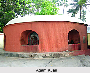
Tourism in Patna District offers the visitors several exploring options of religious and historical sites. Some of the noteworthy tourist attractions of Patna District are Agam Kuan, Botanical and Zoological Garden, Jalan Museum, Gandhi Sangrahalaya, Martyr`s Memorial, Kumhrar, Patna Museum, Planetarium, Patthar ki Masjid, Srikrishna Science Centre, Takth Harmandir and Sher Shah Suri Masjid. Interestingly, some of these places reflect the rich past of the region. All these places draw the attention of the travellers from all parts of the country.
Patna District comprises five sub-divisions and 16 Community Development Blocks. It has 13 towns and 1428 villages. It lies on the main line of the Eastern Railway and is well connected by road.


