Introduction
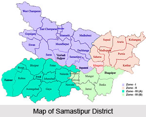
Samastipur District is one of the 38 districts of Bihar and Samastipur is the district administrative headquarters. The modern sub-division of Samastipur (originally Shamsuddinpur) was founded by Hazi Shamsuddin Ilyas of West Bengal. Samastipur District occupies an area of 2904 sq kms.
History of Samastipur District
History of Samastipur district dates back to the period around 1325-1525 AD, when it was a portion of the district of Darbhanga, Bihar. The Sugauna Dynasty, which was also referred to as the Oinwara dynasty or the Kameshwara Thakur dynasty used to rule Darbhanga. The Muslim conquerors, who, by this time had defeated the armies of Mithila, did not interfere with the political powers of the Hindu Chiefs. The Oinwara Dynasty patronised fine arts and learning. Their palaces became centres which promoted the study of Sanskrit philosophy and letters. Amiykara, Amartakara, Gadadhara, Vidyapati, Vachaspati Mishra and Sankara were a few of the reputed Sanskrit scholars during that age.
The founder of the Oinwara Dynasty, namely Kameshwara used to reside in Oini village which is located near Pusa Road in Darbhanga. When the region of Torhut was divided into two separate parts by Bengal`s Hazi Ilyas, the king of Oinwar dynasty moved his capital to Sugauna, a place which is near Madhubani. The northern part of Darbhanga district was controlled by Oinwaras while the southern regions of this district were ruled by Hazi Ilyas. Samastipur, which was initially known as Shamsuddinpur was actually founded by Hazi Shamsuddin Ilyas. Historical records claim that Samastipur became a separate district in the year 1972 after it was split from Darbhanga district.
Temples in Samastipur District
 Temples in Samastipur District is attracted by the people of Bihar and this district. The temples flower the pilgrimage tourism in this district. Some of the major pilgrimage sites are:
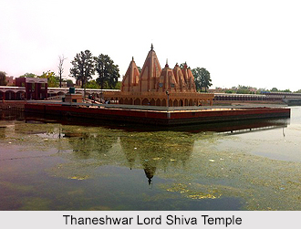
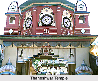
Thaneshwar Lord Shiva Temple
A temple of archeological and historical importance, Thaneshwar Temple is a temple where the people from all parts of state come and offer prayer. Thaneshwar Temple is a very famous temple of Lord Shiva, and is situated at the heart of the city.
Khudneswar Shiva Temple
Khudneswar Shiva Temple is located at about 17 kilometers form Samastipur District near Morwa block. The art and architecture of Khudneswar Shiva Temple shows the unique example of Hindu-Muslim unity in this region. In side, the temple within a distance of few meters there is "majar" of Khudno Bibi along with Shiva linga. This temple is dedicated to Lord Shiva. The Khudneswar Shiva Temple is presently under renovation by local society members. During the festival of Mahashivaratri, there are the crowds from all corners of district are visiting this place for the prayer.
Manipur Bhagwatisthan Durga Temple
Manipur Bhagwatisthan Durga Temple is one of the oldest temples in Samastipur District. This temple is dedicated to Goddess Durga temple in Shekhopur. People from all parts of the state come in numbers to pray Goddess Durga everyday from far off places. This temple aged more than 200 years old temple.
Vidyapati Baleshwar Sthan Shiva Temple
Vidyapati Baleshwar Sthan Shiva Temple is one of the famous temples at Vidyapatinagar in Samastipur District in Bihar. Vidyapatinagar is known as the place of Nirvana of the great Saint and Poet Vidyapati Thakur. Dekari is the place situated in Dalsinghsarai subdivision, is the place where Vidypathi took his last breath.
Durga Temple in Kessopatt
Durga Temple in Kessopatt is one of the oldest temples in this district. Every year on the eve of Durga Puja pilgrims come for worship.
Geography of Samastipur district
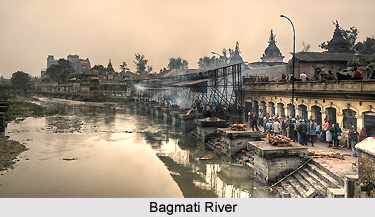
Samastipur district is bounded on the north by the Bagmati River which separates it from Darbhanga District. On the west it is bordered by Vaishali and some part of Muzaffarpur District, on the south by the Ganga River, while on its east it has Begusarai and some part of Khagaria district. Hindi language is the main language spoken in the district.
Samastipur is situated on the banks of the Budhi Gandak River. Besides Budhi Gandak other rivers are Kamala Balaan River and the Ganga River touching the south of the district. Administration of this district comprises four sub-divisions namely Dalsinghsarai, Patori, Rosera and Samastipur Sadar and 20 Community Development Blocks. The blocks are Jitwarpur, Kalyanpur, Warisnagar, Rosara, Tajpur, Morwa, Patori, Sarairanjan, Pusa, Ujiyarpur, Dalsinghsarai, Singhia, Hasanpur, Mohiuddinnagar, Bibhutipur, Bithan, Shivajinagar, Vidyapatinagar, Khanpur and Mohanpur. It has 5 towns and 1248 villages.
Demography of Samastipur District
According to the Population Census in the year 2011, Samastipur District had population of 4,254,782. Out of which the male and female were 2,228,432 and 2,026,350 respectively. The population of Samastipur District constituted 4.10 percent of total population of Bihar. The average literacy rate of Samastipur in 2011 was 63.81 compared to 45.13 of 2001. If things are looked out at gender wise, male and female literacy were 73.09 and 53.52 respectively. The total literates in Samastipur District were 2,214,498 of which male and female were 1,333,406 and 881,092 respectively.
Economy of Samastipur District
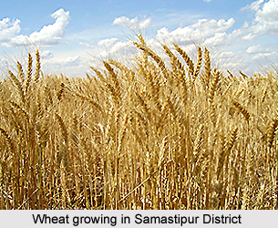 Economy of Samastipur District is dependent on agriculture. Agriculture is the main economic occupation of Samastipur District and about 83 per cent of the total working population depends on it. Samastipur is noted for its fertile alluvial soil and its rabi crops. Wheat, pulses and edible oilseeds are mainly grown here.
Education in Samastipur District
Samastipur District is lacking in educational infrastructure and the literacy rate is only 45.13 percent (male 57.59 percent, female 31.67 percent). The district still lacks in good education facility. Education facilities in the district are at minimum, which includes some colleges like Samastipur College, BRB College, RNAR College, and SMRCK College. There is no professional college in the district. But this district possesses a very reputed Agricultural College in Pusa, well known as Rajendra Agricultural University Pusa.
Tourism in Samastipur District
In Samastipur District, there are various places of interest, which are worth exploring. Vidyapatinagar, Malinagar, Mangalgarh, Jageshwar Asthan, Musrigharari and Thaneshwar Temple are the major attractions of Samastipur District. All these attractions of Samastipur District offer a memorable experience to the travellers. The medical facilities are also not adequate but there are efforts to improve the condition.
 Tourism in Samastipur District gives a pleasurable experience to the travelers. It offers visits to various religious and historical sites that are worth visiting. Tourism in Samastipur District is mainly popular for its temples.
Some of the tourist attraction sites that enchanted the people of this district and the tourists who come from abroad are:
Vidyapatinagar: The place, situated in Vidyapatinagar block near the bank of River Ganges River, is named after the most revered Maithili poet Vidyapati Thakur.
Malinagar: The village, situated about 35 kms southwest of Laheriasarai of Darbhanga District, contains an old Lord Shiva temple that was built in 1844. A fair is held here every year on the eve of Ramnavami.
Mangalgarh: It is situated at a distance of 14 kms from Hasanpur block of Samastipur near Dudhpura. Dudhpura is the nick name of ancient Budhpura, which was named after Lord Buddha who stayed there and preached Buddhism for some time.
Jageshwar Asthan: It is an old Shiva temple in Bibhutipur village situated about 15 kms from Narhan Railway station. There is also a magnificent old Building of Narhan Estate, which has been very prominent in this area since the Mughal period.
Musrigharari: It is situated at a distance of about 8 kms from Samastipur main town. This place is very famous for Muharram and Durga Puja celebrations.
Thaneshwar Temple: Thaneshwar Temple is a very famous temple of Lord Shiva, and is situated at the heart of the city.
There are numerous other temples as well. A very famous temple `Khudneshwar Sthan` is also there situated in village Morwa. These places of interest of Samastipur District attract people several corners of the country.