 Darbhanga District is a significant administrative district of Bihar. It is one of the 37 districts of the state with its headquarters at Darbhanga. Darbhanga District occupies a total geographical area of 2279 sq km. It is situated between longitude 85 degree 45 minutes to 86 degree 25 minutes east and latitude 25 degree 53 minutes to 26 degree 27 minutes north. Darbhanga District is bounded on the north by Madhubani District, on the south by Samastipur District, on the east by Saharsa District and on the west by Sitamarhi District and Muzaffarpur District. Main languages spoken in this district are Maithili language, Hindi language and Urdu language. Administration of Darbhanga District comprises three civil sub-divisions, 18 Blocks, 329 Panchayats, 1269 villages and 23 Police Stations. There is also a municipal corporation having 37 wards in the urban area.
History of Darbhanga District
Under the British rule, Darbhanga was a part of Sarkar Tirhut up to the year 1875, when it was declared as a separate district. The sub-divisions of the then district Darbhanga were created as earlier as Darbhanga Sadar in 1845, Madhubani in 1846 and Samastipur in 1867. Darbhanga was part of Patna Division till 1908, when the separate Tirhut Division was carved out. Darbhanga became the Divisional headquarters in 1972 when all its three sub-divisions got the status of separate districts. Thus, the present Darbhanga district took shape.
Geography of Darbhanga District
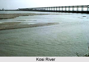
Geographically, Darbhanga District can be divided into four natural divisions. The eastern portion consisting of Ghanshyampur, Biraul and Kusheshwarsthan blocks contain fresh silt deposited by Kosi River. It contains large tracts of sandy land covered with wild marsh. The second division comprised of the anchals lying south of the Budhi Gandak River and is the most fertile area in the district. It is also on higher level than the other part of the district and contains very few marshes. It is well suited to the rabi crops. The third natural region is the region between the Budhi Gandak and Bagmati River and consists of low-lying areas. It gets floods every year. The fourth division covers the Sadar sub-division of the district. This tract is watered by numerous streams and contains some up-lands.
Further, geography of Darbhanga District has a vast plain land of alluvial soil devoid of any hills. There is a gentle slope from north to south with a depression on the centre. The district has somewhat dry and healthy climate. There are three main seasons, the winter, the summer and the rainy season. The cold weather season begins in November and continues up to February, though March is also somewhat cool. Westerly winds begin to blow in the second half of March and temperature rises considerably. May is the hottest month when the temperature goes up to 107 degree Fahrenheit. Rain sets in towards the middle of June. With the arrival of rainy season, temperature falls and humidity rises. The rain continues till the middle of October. Average rainfall is 1142.3 mm; around 92 percent of rainfall is received during monsoon months. The land in Darbhanga District is generally very fertile and there are hardly any uncultivated areas. The district is, therefore, devoid of any forests.
Demography of Darbhanga District
According to the 2011 Census, Darbhanga district had a population of 3,921,971. Out of which the male and female were 2,053,043 and 1,868,928 respectively. The population of Darbhanga District constituted 3.78 percent of total population of Bihar. The average literacy rate of Darbhanga in 2011 was 58.26 percent compared to 44.33 percent of 2001. If things are looked out at gender wise, male and female literacy were 68.58 percent and 46.88 percent respectively. The total literate in Darbhanga District were 1,876,638 of which male and female were 1,158,664 and 717,974 respectively.
Tourism in Darbhanga District
Several tourist attractions in Darbhanga District are worth seeing. It includes exploring of several historical as well as religious sites. Ahilya Asthan, Brahmpur, Chhaprar, Kusheshwar-sthan, Shyama Temple, Nawadah Durga-sthan, Mahinam-Mahadeo-sthan, Manokamna Temple, Catholic Church and Masjid at Darbhanga Tower are some of the popular places of interest offered by Darbhanga District.


