Introduction
 Madhubani District is one of the 38 administrative districts of Bihar and Madhubani town is the district headquarters. Madhubani District occupies a total area of 3501 sq kms. It is located at a longitude of 25 degree 59 minutes to 26 degree 39 minutes east and latitude of 85 degree 43 minutes to 86 degree 42 minutes north. Madhubani District is situated at height of 80 meters above the sea level. This district is bounded on the north by a hill region of Nepal and extending to the border of Darbhanga District in the south, by Sitamarhi District in the west and by Supaul in the east. Madhubani fairly represents the centre of the territory once known as Mithila and the district has maintained a distinct individuality of its own.
History of Madhubani District
 History of Madhubani District in Bihar states that this district was carved out from old Darbhanga District in the year 1972 because of reorganization of the districts in Bihar. Madhubani District was formerly the northern sub-division of Darbhanga District.
Early History of Madhubani District : There are no prehistoric sites in the district though remains of the earliest aboriginal population can be seen in some parts of the district. Some historical accounts have referred to the existence of the people namely Tharu tribe and Bhar in the erstwhile old sub-division of Madhubani. It also appears that Kiratas also inhabited the district for a considerable period. Bihar settlements in the northeastern part of the district indicate that they possibly wielded some power in the remote part. Prior to Aryanisation of this area seems to have been under the aboriginal population and Lord Shiva worship was predominant. The kingdom of Videhas included a greater portion of Madhubani District. Traditions associated with this district also say that the Pandavas during their exile stayed in some portion of the present district and Pandaul (block headquarters) is associated with them. Legends and traditions associate this district with a number of sages of ancient times. Since the whole of North Bihar was deeply influenced by the teachings of Lord Mahavira and Lord Buddha, it is only natural to infer that the people of Madhubani actively participated in the propagation of these reform movements. Both Jain and the Buddhist literature contain innumerable references of Madhubani District and its neighbouring territories. However, very little is known about the history of Madhubani District from the time of the Kushana Empire to the rise of the Gupta Empire.
Medieval History of Madhubani District : After a temporary period of instability, Madhubani came under the control of the Oinwaras, also known as Sugauna dynasty. When Hajiriyas of Bengal divided Tirhut into two parts, Oinwar Raja shifted his capital to Sugauna near Madhubani. There was no event of great significance during the next century and a half. The decisive victory of the British in the Battle of Buxar in 1764 gave them undisputed sway over the lower provinces of Bengal. Therefore, Madhubani, along with other parts of Bihar, passed under the control of British.
Modern History of Madhubani District : The British administrators took steps to establish law and order. In 1857, patriotic fervour raged-high in Madhubani District as in many other districts of Bihar. Later the call of the non-co-operation movement also found adequate response in the district. Further, according to the history of Madhubani District, Khadi became very popular and Madhubani soon emerged as a renowned centre of Khadi production. The popularity of Khadi weaving and spinning in the district went a long way in inspiring the people towards the nationalist cause. Thus, history of Madhubani District shows that this district played an important role in the country`s freedom struggle.
Geography of Madhubani District
 Geography of Madhubani District in Bihar consists of a vast low-lying plain intersected by numerous streams and marshes, but traversed in parts by upland ridges. The land is generally high, especially in blocks of Benipatti, Madhubani, Jainagar, Ladania, Laukaha and in the south of Phulparas, which contain stretches of highland. The soil of Madhubani District is highly calcareous. It is a mixture of clay and sand in varying proportions. Geography of a major part of the district includes clay. This contains negligible proportion of sand and since it can retain moisture, it is suitable for paddy cultivation.
As far as the shape of the region is concerned, the district resembles a parallelogram, its mean breadth from west to east being a little greater than its mean length from north to south. Further, topographical features of Madhubani District also consist of a rich alluvial plain traversed by several rivers running almost parallel to each other from north to south. The important rivers of the district are Bagmati River, Kamla River, Kareh River, Balan River and Tiljuga River. The Bagmati enters the district at Bishanpur Agropatti about 16 kms west of Benipatti, and after being joined by its tributary Dhaus near Bankatta. It takes a south- easterly course. Kamla River frequently changes its course and its beds are found all over the northern part of the district.
Geography of Madhubani District is characterized by moderate and healthy climatic conditions. The climate of this district includes three well marked seasons, namely a pleasant cold season, a hot, dry summer and the rainy season. The cold weather begins in November and continues up to February, though March is also somewhat cool. Westerly winds and dust storms begin to blow and the temperature goes up to about 42 degree Celsius. Rains set in towards the middle of June when the temperature begins to fall and humidity rises. It continues till the end of September or the middle of October and these months are not so hot. Madhubani District gets more rain than its adjoining districts. Maximum rainfall occurs between the second half of July and first half of August. The average annual rainfall in the district varies between 900 mm and 1300 mm. The district also gets some winter rain.
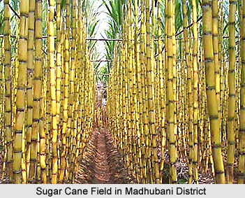
Land in the district is mainly low and produces one crop in a year, and so the necessity for high cultivation does not arise. So far as agricultural production is concerned, the district is mainly a paddy and sugarcane growing area. Madhubani District, like other districts of North Bihar, is dependent for its crops on the local rainfall. However, a considerable part of the district is flood prone.
Demography of Madhubani District
 The population Census 2011 says that Madhubani District had population of 4,476,044 of which male and female were 2,324,984 and 2,151,060 respectively. The population of Madhubani District constituted 4.31 percent of total population of Bihar. The average literacy rate of Madhubani in 2011 was 60.90 compared to 41.97 of 2001. If things are looked out at gender wise, male and female literacy were 72.53 and 48.30 respectively. The total literates in Madhubani District were 2,251,107 of which male and female were 1,393,708 and 857,399 respectively.
Economy of Madhubani District
Economy of Madhubani District is basically dependent on agriculture. Major crops grown in the district are Wheat, Sugarcane and Pulses. Rearing of cattle is an important subsidiary occupation of the district. The district is well stocked with cattle. A number of veterinary hospitals and dispensaries have been opened at different centres in the district which has reduced the mortality of cattle. In terms of trade and commerce, this district exports fish, handloom cloth, mangoes, sugarcane, paddy, and brass metal articles to various cities insides and outside the state. It imports medicine, machine, fine clothes, shoes, and cosmetic materials from other places. A number of rice mills and timber saw mills have been set up in the district. Madhubani has been an important centre for trade.
Culture of Madhubani District
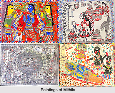
Spinning and weaving are very old and highly developed handicrafts in Madhubani District. The Khadi Gramodyog Centre located at Madhubani is famous for weaving. This speaks of the high quality of the handloom textile of the district. The famous Madhubani Painting or the Mithilia Painting as it is known is also the handwork of the people especially the women of Madhubani.
Tourism in Madhubani District
 Tourism in Madhubani District in Bihar means a memorable and heartening experience for the travellers. Madhubani District has a number of places having tourist interest from religious, historical and archaeological point of view. Tourism in this district of Bihar offers visits to several historical as well as religious sites. Some of the prominent places of Madhubani District are Andhratharhi, Balirajpur, Mangrauni, Ucchaith, Bhawanipur, Saurath, Satghara and Bisfi. Brief description of places having religious, historical and archaeological importance in the district is as follows -
Saurath: This is a road side village on Madhubani-Jaynagar road and is renowned for a temple known as Somnath Mahadev. It owes its importance to the annual Sabha held by Maithili Brahmins for negotiating marriages.
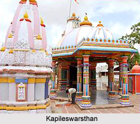
Kapileswarsthan: A village situated nine kms from Madhubani District headquarters. The village is noted for its Lord Shiva Temple, also known as `Kapileswarsthan`. Numerous devotees congregate at the temple every Monday and particularly in the month of Shravan. A large fair is also held on Mahashivratri.
Uchaitha: The village in Benipatti block is noted for its temple of Bhagwati on the western bank of Thumne River. According to a legend, renowned Sanskrit language poet and dramatist Kalidasa was blessed by Goddess Sarawasti at this place.
Bhawanipur: It is a large village situated five kms away from the block headquarter of Pandaul. The village is noted for its temple of Ugaranath and traditional association with famous poet, Vidyapati. As the legend says, Vidyapati was such a great devotee of Lord Shiva that the latter began to serve Vidyapati as his servant named Ugana. All these tourism spots of Madhubani District attract travellers from different corners of the country.