Home > Travel > States of India > Geography of Patna District
Geography of Patna District
Geography of Patna District is mainly spread over vast plain land. It does not comprise any hilly terrain.

Share this Article:

Geography of Patna DistrictGeography of Patna District does not contain any hilly region. It has an entirely alluvial and flat region. Topography of Patna District can be divided into two categories. Firstly, a narrow strip of somewhat high land about eight kms in width along the southern bank of the Ganga River having very fertile soil and secondly alluvial fertile plains in the remaining portions.

Geography of Patna District is characterized by fertile lands. However, the district is devoid of any forest wealth. The alluvial text of land yields rice, sugarcane and other food grains. The area under cultivation is studded with mango orchards and bamboo clumps. In the fields adjoining the Ganges weeds such as ammannia, citriculari, hygrophile and sesbania grow. However, palmyra and date palm and mango orchards are found near habitations. Dry shrub jungles are sometimes seen in the villages away from the rivers.

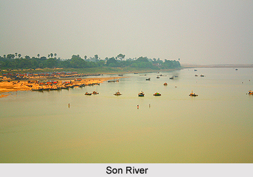
Geography of Patna District includes two main rivers - Ganga River and Son River. The next important river of the district is the Punpun River The greater part of the district is watered by streams, which descend from the Chota Nagpur Plateau to join Ganges. The Ganges, which runs all along the northern boundary of the district, separates it from Saran District, Tirhut District and Darbhanga District divisions. It is the largest river of the district. It enters the district at its confluence with the Son and flows for 148 kms in the eastern direction up to Dumra. Gandak River joins the Ganges just opposite of Patna.

Son River, rising in the Maikal range near Amarkantak in the Deccan Plateau and after traversing around 624 kms it touches Patna District at Mahabalipur from where it flows in northerly direction for 65 kms until it joins the Ganges. The river constitutes a natural boundary between Patna District and Bhojpur District. It has a long rail-cum-road at Koiwar. Punpun River enters the district from the south and flows to the north easterly directions. It crosses the Patna-Gaya Railway line near Punpun Railway station and joins the Ganges near Fatwah after flowing for around 86 kms through the district. The Morhar joins it and the Dardha River before it meets the Ganges.


Share this Article:

Related Articles

More Articles in States of India


East Indian States
East Indian States comprises of Bihar, Jharkhand, West Bengal, Odisha and also the Union Territory of Andaman and Nicobar Islands. It defines the cultural heritage, rich historical background and the linguistic unity.
Erode District
Erode District is one of the districts in the state of Tamil Nadu. The district of Erode is having a land-locked area with no sea coast.
Purnia District in Bihar
Purnia District is located in Bihar and extends from River Ganga to Nepal. The district has a rich Hindu history and glorious past.
South Delhi District
South Delhi District is the third largest district of Delhi as far as its area is concerned. South Delhi District is known for its economic, historical, cultural and social significance.
North Indian States
North Indian States formed the cultural and religious unity in spite of having many foreign invasion and the political disturbances from the early era till the British gained supremacy in Indian sub continent.
Kendujhar District
Kendujhar District, spread over an area of 8,240 sq kms, is as varied as the whole of Orissa with waterfalls roaring gorges, mountains and minerals. The manifold expressions of nature in Kendujhar District are considered as unique.
Hooghly district
Hooghly District along the bank of the river Hooghly is one of the principal trading ports of West Bengal.
Districts of South Tamil Nadu
Districts of South Tamil Nadu consist of many tourism destinations like archaeological sites and the history of Pandyas and Cholas. Considering their proximity to the sea, many districts also boast of serene beaches and coastal beauty.
Flora of Arunachal Pradesh
Flora of Arunachal Pradesh includes infinite species and is a subject of great interests for the botanists.
Districts of South Gujarat
Districts of South Gujarat are the epicenter of Jain pilgrimages and the early Hindu kingdoms.
North West States of India
North West States of India consist of three states, which are Rajasthan, Punjab and Haryana. All of them are culturally and traditionally diverse and they have been ruled by different dynasties in historical time.
Geography Of Chittoor District
Geography of Chittoor district is spread along the topography of the land which is divided into two natural divisions; Chittoor has a dry and healthy climate.
Districts of North Rajasthan
District of Northern part of Rajasthan is dotted with ancient forts and medieval villages.
Districts of North Odisha
District of North Odisha has Bengal boundary and shares the same culture. These are reachable if one pays a weekend visit to Digha.
Districts of West Bihar
Districts of West Bihar is comprised of medieval monuments that were built by the different governors of Mughal era.
Districts of South Haryana
Districts of South Haryana consists of many cities of industrial excellence. These districts are dotted with popular tourism destinations.
Medieval History of Assam
Medieval history of Assam narrates the advent and rule of a number of kingdoms in the region. The prominent dynasties of the kingdom left an everlasting imprint on the socio cultural heritage of India.
Geography of Meghalaya
The suitable climate, highland plateaus, rivers and the flora and fauna together forms the geography of Meghalaya.
Districts of Rayalaseema
Districts of Rayalaseema in Andhra Pradesh state has urban population and rural settlements as well.
Districts of South Punjab
Districts of Southern part of Punjab depict medieval history of Punjab and the rise of Sikhs.