 Indian Islands play a significant role in making the country a beautiful destination. The surging Indian Islands are well-encompassed by lush forests and possess an infinite variety of striking fauna and flora. The beauty of the Arabian Sea and the cobalt hue of the Bay of Bengal lend a magical touch to the Indian Islands. There are several islands in India which are well-known for their tourist importance. These Indian Islands are distributed in various Indian states and many of them are given below.
Islands of Western India
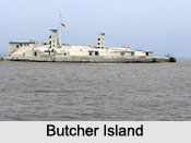
Salsette Island is one of the most densely populated islands in the world as the metropolis of Mumbai and the cities of Thane and Mira-Bhayandar lie on it. Butcher Island, also known as Jawahar Dweep is an island off the coast of Mumbai. Oyster Rock is an island located in the Mumbai Harbour. 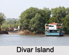 Piram Island is located in Bhavnagar district. This island occupies about 186 acres, half of it being wasteland. Bet Dwarka is located about 3 km (2 mi) off the coast of Okha at the mouth of Gulf of Kutch. This inhabited island is a strip of sand and stone. Pirotan Island is an Arabian Sea island in Jamnagar district. It occupies an area of about 3 sq kms. Chorao is an island along the Mandovi River near Ilhas. Salim Ali Bird Sanctuary is situated in the western part of the island. Anjediva Island is located in the Arabian Sea off the coast of Canacona in the South Goa District. Divar Island is situated in the District of North Goa. Some of the other Islands of Western India are Underi, Yeshwantgad, Panju Island, Man Marodi Island, Kyu Island, Devdi Island, Sao Jacinto Island and Grand Island.
Islands of Eastern India
Ghoramara Island is located about 92 km south of Kolkata, in the Sunderban Delta Complex of the Bay of Bengal. This island roughly occupies an area of about 5 sq kms. Nayachar is an island located off Haldia in Purba Medinipur in the Hooghly River. 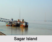 The total area occupied by this island is about 64 sq kms (25 sq mi). Sagar Island is located on the continental shelf of Bay of Bengal, about 100 km (54 nautical miles) south of Kolkata. Dr. Abdul Kalam Island is an island off the coast of Odisha. Some of the other Islands of West Bengal are Morichjapi, Lohachara Island and Henry Island.
Islands of North East India
Majuli is a river island in the Brahmaputra River in Assam and the 1st Island District of India. Due to erosion the area of the island got reduced to only 352 sq kms (136 sq mi) in 2014. It is mentioned in the Guinness Book of World Records as the World`s Largest River Island.
Islands of Southern India
Bhavani Island is situated in Vijayawada in the midst of Krishna River. It occupies an area of about 133 acres (54 ha). Sriharikota is a barrier island off the Bay of Bengal coast located in Andhra Pradesh. Willingdon Island is a part of the city of Kochi. It has the distinction of being the largest man-made island in India and was established using the sand dug out while deepening the Kochi port. Pathiramanal is a small island on the Vembanad Lake in Muhamma Panchayat of Alappuzha district. Netrani is a small island located in the Arabian Sea and belongs to Indian state of Karnataka. Basavaraj Durga Island in the Arabian Sea near Honnavar is a part of Honnavar Taluk in Karnataka. Some of the other islands of Southern India are Hope Island, Diviseema, Kuruvadweep and St. Mary`s Islands.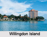
Andaman and Nicobar Islands
Andaman and Nicobar Islands is one of the seven union territories of India. This island comprising an area of about 8,249 sq kms is further divided into several other islands. Some of them are Barren Island, Little Andaman, Car Nicobar, Rutland Island, North Sentinel Island, Katchal Island and Teressa Island.
Lakshadweep Islands
Lakshadweep Islands is a group of islands in the Laccadive Sea, 200 to 440 km (120 to 270 mi) off the south western coast of India. It is an archipelago and a union territory. More specifically, it is an archipelago of 12 atolls, 3 reefs and 5 submerged banks with a total of about 39 islands and islets. Its major islands are Kavaratti, Agatti, Minicoy and Amini.


