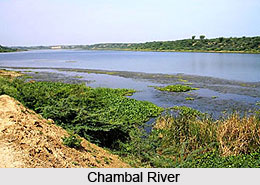
 A principal tributary of the Yamuna River is the Chambal River (also known as Charmanwati, or Charmawati), which is an important river of the Malwa Plateau. It is a perennial river, which arises at Manpura, which is in the south of Mhow town near Indore. It is in the southern slope of the Vindhya Range in Madhya Pradesh. Geographically, the river is situated between 22degree 27` North latitude and 73degree 20` East longitudes at a height of 354 metres.
The river flows through Dhar district for 17 kilometers dividing the Sagar Project in the east. It flows along the Ujjain, Ratlam and Mandsaur districts, which lies in the northern portion of the Gwalior Division. While the Chambal and the tributaries drain the Malwa region which is in the northwestern part of Madhya Pradesh, the Banas River which is the tributary of the Chambal River flows in the southeastern part of Rajasthan.
Mythological Significance of Chambal River
The Chambal River, known in antiquity as Charmanvati, derives its name from its historical association with the drying of leather on its banks. Over time, this watercourse gained renown as the river of `charman` or skin, leading to its designation as Charmanvati. In the revered Sanskrit epic, the Mahabharata, the Chambal River is identified as Charmanyavati, believed to have originated from the blood of numerous animals offered in sacrifice by King Rantideva.
The scale of animal sacrifices conducted during King Rantideva`s Agnihotra rituals was so vast that the secretions emanating from the accumulations of skins in his kitchen gave rise to an actual stream. This phenomenon led to the river being christened as Charmanwati. Charmanwati demarcated the southern borders of the Panchala Kingdom, under the rule of King Drupada. His authority extended up to the banks of the Charmanwati river.
Folklore recounts that the expanse around the Chambal River was once part of Shakuni`s realm, notably associated with the fateful dice game in the Mahabharata. Following the harrowing episode of Draupadi`s attempted disrobing, being the daughter of Drupada, she pronounced a curse upon those who would consume the waters of Charmanwati. This curse, attributed to Draupadi, is believed to have shielded the Chambal River from human-induced pollution, allowing its diverse animal inhabitants to flourish undisturbed. As a result of this curse, the Chambal River has endured as one of India`s most untainted water bodies.
Course of Chambal River
The Chambal River, stretching across 1,024 kilometers, originates from the Bhadakla Falls situated in the Janapav Hills on the northern slopes of the Vindhyan escarpment near Mandav. This location lies 67.5 kilometers to the South-West of Mhow in the Indore District of Madhya Pradesh state. Its source is marked at an elevation of approximately 843 meters above sea level.
Initially, the river courses in a northerly direction through the expanse of Madhya Pradesh, covering a distance of roughly 376 kilometers. Subsequently, it alters it diverts to a generally north-easterly course, traversing 249 kilometers through the state of Rajasthan. The Chambal`s journey continues with an additional 216 kilometers flowing between Madhya Pradesh and Rajasthan, followed by a further 150 kilometers between Madhya Pradesh and Uttar Pradesh. As it enters Uttar Pradesh, the river extends for about 33 kilometers before merging with the Yamuna River in Jalaun District at an elevation of 123 meters. This confluence marks its integration into the greater Gangetic drainage system.
Throughout its course from its origin to its union with the Yamuna, the Chambal River experiences an overall descent of approximately 747.25 meters. Of this decline, the river encounters an additional drop of 195 meters as it enters the gorge beyond the Chaurasigarh Fort. In the subsequent span of 157 kilometers between the Chaurasigarh Fort and Kota city, the river`s bed descends by another 91 meters. The remaining segment of the Chambal`s course takes it across the level terrain of the Malwa Plateau and subsequently the Gangetic Plain, maintaining an average gradient of 0.21 meters per kilometer.
The Chambal River constitutes a rain-fed catchment area with a combined drained region extending up to its confluence with the Yamuna, covering 144,591 square kilometers. The drainage basin takes on a rectangular shape, with the Chambal tracing its principal axis. To its south, east, and west, the basin is defined by the Vindhyan mountain ranges, while the north-western boundary is marked by the Aravalli range. Downstream of the confluence of the Parvathi and Banas Rivers, the catchment becomes narrower and elongated. In this stretch, the river is bordered by the Aravalli mountains on the North and the Vindhyan hill range on the south.
The left bank of the Chambal River is flanked by the Vindhyan scarps in the northwest, which largely contributes to its drainage. The river, along with its tributaries Kali Sindh and Parbati, has formed an alluvial basin with a triangular configuration, situated around 200–270 meters above the lower Chambal`s narrow trough in Kota.
Tributaries of Chambal River
The Chambal River is enriched by a network of tributaries that contribute to its flow and hydrological significance. These tributaries, varying in size and origin, channel their waters into the Chambal River, collectively shaping its hydrological course and contributing to the river`s overall flow and significance within the region. They include the following:
1. Shipra
2. Choti Kalisindh
3. Sivanna
4. Retam
5. Ansar
6. Kalisindh
7. Banas
8. Parbati
9. Seep
10. Kuwari
11. Kuno
12. Alnia
13. Mej
14. Chakan
15. Parwati
16. Chamla
17. Gambhir
18. Lakhunder
19. Khan
20. Bangeri
21. Kedel
22. Teelar
Flora on Chambal River Basin
Nestled within the semi-arid expanse at the intersection of Madhya Pradesh, Rajasthan, and Uttar Pradesh states, the Chambal River Basin`s flora thrives amidst a challenging environment. Characterized by ravine formations and thorn forests, it falls under the Northern Tropical Forests` revised classification by Champion & Seth (1968). This classification is typically indicative of regions receiving 600-700 mm of rainfall, representing a less arid ecological setting. The landscape occasionally features patches of Saline/ Alkaline Babul Savannah, which aligns with the Northern Tropical Dry Deciduous Forest type.
The semi-arid belt of Madhya Pradesh extends to the Chambal catchment, encompassing the reach up to the Narmada and Betla Rivers. Within this expanse, a diverse array of over 1000 flowering plant species have been documented. Among them, notable mentions include Anogeissus latifolia, A. pendula, Tectona grandis, Lannea coromandelica, Diospyros melanoxylon, Sterculia urens, Mitragyna parviflora, Butea monosperma, Emblica officinalis, Boswellia serrata, Bridelia squamosa, and Hardwickia binata. The shrub and ground layer compositions bear resemblance to the semi-arid regions of Gujarat. Climbers such as species of Rhynchosia, Atylosia, Cocculus, Cissampelos, Ipomoea, Pergularia daemia, Pueraria tuberosa, and Tinospora cordifolia contribute to the botanical tapestry.
The terrain is punctuated by thorny shrubs and diminutive trees that have acclimated to the region`s conditions. These encompass Capparis decidua, Capparis sepiaria, Balanites aegyptiaca, Acacia senegal, A. nilotica, A. leucophloea, Prosopis juliflora, Butea monosperma, Maytenus emarginata, Tamarix species, Salvadora persica, S. oleoides, Crotalaria medicaginea, C. burhia, Clerodendrum phlomidis, Calotropis procera, Xanthium indicum, and Leptadenia pyrotechnica. Climbing plants such as Maerua oblongifolia and Pergularia daemia, along with various herbs including Argemone mexicana, Farsetia hamiltonii, Tephrosia purpurea, Cleome viscosa, Tribulus terrestris, and Glinus lotoides, contribute to the diverse vegetation. Grasses such as Cyprus species, Fimbristylis species, Brachiaria species, Cenchrus species, Dichanthium species, and others contribute to the overall plant diversity within the basin.
National Chambal Sanctuary
Located within the expanse of Dholpur, the National Chambal Sanctuary encapsulates a significant segment of the Chambal River, spanning from the Jawahar Sagar Dam in Rajasthan to the Chambal-Yamuna confluence in Uttar Pradesh. This sanctuary safeguards two distinct stretches of the Chambal, the upper sector stretching from Jawahar Sagar Dam to Kota Barrage, and the lower sector extending from Keshoraipatan in Rajasthan to the Chambal-Yamuna confluence in Uttar Pradesh.
Established with the imperative to restore ecological equilibrium to a crucial north Indian river system and to provide comprehensive protection to the highly endangered gharial, the National Chambal Sanctuary was accorded gazetted status. The initiative received administrative endorsement from the Government of India on 30 September 1978. This sanctuary status is conferred under the Wildlife Protection Act, 1972.
Dams on the Chambal River
The Chambal River embarks on a transformative journey, manifesting a varied topographical canvas as it courses through its expanse. In the initial stretch of 96 kilometers from its source, the river navigates a profound gorge, and further downstream, the landscapes broaden into expansive plains. Amidst these terrains, strategic dam constructions have harnessed the river`s potential, establishing reservoirs that serve diverse purposes along its course.
Gandhisagar Dam, strategically positioned at the heart of this gorge section, capitalizes on the geographic advantages. The presence of an immediate upstream gorge grants the dam a substantial storage capacity despite its relatively modest stature. This dam is used for hydropower generation, contributing to the broader Chambal Valley Projects, which also encompass Rana Pratap Sagar Dam and Jawahar Sagar Dam.
Rana Pratap Sagar Dam, positioned 52 kilometers downstream of Gandhisagar Dam, signifies the next phase in this orchestrated river management. Completed in 1970, this dam further accentuates the capacity for hydropower generation. Its power station houses four generating units, each with a capacity of 43 MW.
The journey continues with the Jawahar Sagar Dam, the third in the Chambal Valley Projects sequence. Found 29 kilometers upstream of Kota city, this concrete gravity dam stands as a prominent milestone, generating 60 MW of power across its three units. Completed in 1972, the dam`s strategic positioning and operational capacity underscore its contribution to the holistic river management paradigm.
The final dam on the river is the Kota Barrage, the fourth installment in the Chambal Valley Projects progression. Located just 0.8 kilometers upstream of Kota City, the Barrage functions as a conduit for water released from the upstream dams, diverting it for irrigation purposes through an intricate network of canals on both sides of the river. Serving as a bridge between parts of Kota, it effectively channels flood and canal water downstream, while also maintaining its operational function as a crucial water management structure.


