Introduction
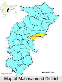 Mahasamund District is one of the administrative districts of Chhattisgarh with city of Mahasamund as its headquarters. Mahasamund District is spread out over an area of 3902.39 sq kms. The district lies between 20 degree 47 minutes to 21 degree 31 minutes 30 seconds latitude and 82 degree to 83 degree 15 minutes 45 seconds longitude. Mahasamund District is surrounded by districts of Raigarh and Raipur of the state and Nuapada District and Bargarh District of Orissa. This district was formed on 6th of July,
History of Mahasamund District
 History of Mahasamund District is the pillar of the tribal culture and the reverberation of the popular culture and the tribal life of the region. It is through the geography and the topographical affluence of the region that the history of the place whispers from the bricked layers of time the devourer.
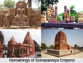
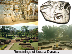
History of this district is coloured by the ephemeral smoke of traditionalism and the aftermath of the same. Once a capital of `South Kosala`; ruled by `Somavansiya Emperors`, the area was a domain for propagation and receiving of knowledge and thus cultural renaissance.
An assortment of numerous temples here and there with their natural and divine beauty delights the anticipatory brain of the visitors and the archaeological vision of the historians. The temples and the fairs/ festivals have become the part and parcel of cultural life of the dwelling populace.
The position of Sirpur is at the top of all international famed historical places of South Kosal i.e,
 present Chhattisgarh. Sirpur, located at the bank of holy Mahanadi River, is completely merged with the cultural and architectural arts. In the old age (at the time of Somavanshiya emperors) Sirpur was known as `Shripur` and was the capital of South Kosala. Sirpur has very special position in the history of Indian art due to the value of vital and original experimentalist as well as religious and spiritual knowledge and science.
Mahasamund is the administrative headquarters of Mahasamund District. The historical city of Mahasamund is also a municipality in the Mahasamund District in the Chhattisgarh state. The History of Mahasamund district has an aura of importance attached to it. A look into the History of Mahasamund tells one and all that there have been tribes living in the region since the ancient times. There are a massive number of different types of tribes living in the city. The different types of tribes are Kamar, Kanwar, Dhanwar, Halba, Kharai, Munda, Pardhi, Bahalia, Saur, Saharia, Sonar, Sanwara, Kharwar, Bhujia and Binjhwar.
It is the history of this region that informs one and all the minute details about the tribes` and their life and the other aspects related to these. The dressing styles and patterns of the people in the city owing to the lifestyle are simple and traditional. The apparel of the male is usually a Dhoti, Kurta and a Turban on their head with a piece of clothing round the neck. They also wear a special type of leather shoe. This leather shoe is known as Bhandai. The female prefer to wear saris with exceptional type of leather footwear known as Atkaria. According to the History of Mahasamund, the dressing style has been followed for decades and is still being maintained. The language spoken here is known as `Chhattisgari`.
Geography of Mahasamund District
In this region various forms of Neo-granite, Dolerite and Quartz are found in intrusive forms. Granite rocks can be found in the Bagbahara, Basna and Pithore regions. In this region there is a great scope of intense mining activity. Further, important deposits found in this region are Gold, Tin ore, Lead ore, Fluorite, Beryl, Granite and Limestone rocks. Several small scale industries are in operation that makes multifarious uses of lime stone. Abundant scope of Granite based industries exists in this district of Chhattisgarh.
Demography of Mahasamund District
As per the Census 2001 the total population of Mahasamund District is 8, 60,176, male population is 4, 26,011 and female population of the district is 4, 34,165. The density of population is 220 people per square kilometres. Sex ratio is 1019 women for 1000 men. The tribal population of Mahasamund District is significant as it accounts for near about 29 per cent of the total population. The major tribes living in the district are Bhujia, Binjhwar Tribe, Dhanwar Tribe, Halba Tribe, Kamar, Kanwar, Kharai, Munda Tribe, Pardhi, Bahalia, Saur, Saharia Tribe, Sonar, Sanwara and Kharwar Tribe.
Districts of Mahasamund Division
 Districts of Mahasamund Division in Chattisgarh include the districts like Mahasamund District, Gariaband District and Baloda Bazar district.
Mahasamund District
Mahasamund District is an administrative district in Chhattisgarh state in eastern India. The city of Mahasamund is the district headquarters. Mahasamund District is bounded by Raipur District, Gariyaband District, Baloda Bazar District, Raigarh District of Chhattisgarh state and Bargarh District and Nuapada District of Odisha state. Mahasamund is located at 21.1 degree North to 82.1 degree East. It has an average elevation of 318 meters. Mahasamund is 56 km Southeast of Raipur on the junction of National Highway 6 and National Highway 217 close to the Mahanadi River. Mahasamund city is an important station on the Raipur-Vizag rail route. Mahasamund and Raipur is the only district headquarter city, which is very close to the Chhattisgarh New Capital Naya Raipur.
Gariaband District
Gariaband District is one of the nine new districts formed in Chhattisgarh, operational from January 1, 2012, ceremonially launched by Chief Minister Dr. Raman Singh on January 11, 2012. Gariaband district was carved out of Raipur district and has its headquarters at Gariaband town. Dhamtari and Mahasamund are the neighbor districts. The district covers an area of 5822.861 sqkm. is full of natural resources. "Pairy" and "Sodhur" river flows north from here and makes "Triveni Sangam" Rajim together. By building Odisha border flows "Tel River". Rajim is a famous pilgrimage center. Every year a "Kumbh Mela" is held from Magh Purnima to Maha Shivaratri. The district is divided into geographical area of the five talukas Gariaband, Chhura, Mainpur, Devbhog and Rajim respectively. The Gariaband, Chhura and Mainpur blocks are Multiplicity of Tribals. There are four urban bodies in the district in which one Municipality (Gariaband) and three Nagar Panchayat. The area of Gariaband Forest is 1951.861 square kilometers and Udanti Sita Nadi Tiger Reserve covers 983.94 square kilometers. Gariaband district starts at the ancient temples of Rajim.
Baloda Bazar District
Baloda Bazar district is a district in Chhattisgarh of India with its headquarters at Baloda Bazar. Before its creation, it was part of Raipur district.
Temples in Mahasamund in Chhattisgarh
 Mahasamund district is an administrative district in Chhattisgarh. The city of Mahasamund is its district headquarters. Mahasamund covers an area of 3902.39 sq. km. located on the eastern part of Chhattisgarh. It is surrounded by Raigarh and Raipur districts of Chhattisgarh and Nuapara and Bargarh districts of Orissa. With a number of temples the Mahasamund district echoes the spiritual aura in a subtle way. Whether the architectural wonder or the divineness the different temples in Mahasamund are indeed the reason, which speaks of the religious splendor of the place.
Anand Prabhu Kudi Vihar, Sripur, Mahasamund, Chhattisgarh: The town of Sripur is primarily known for its Buddha Viharas. The most famous amongst them is `Anand Prabhu Kudi Vihar`, constructed by Bhikshu Anand Prabhu, a follower of Buddha, during the period of Mahashivgupt Balarjun. The Vihara has 14 rooms and the main entrance has the Dwarpal carved in stone on either side of it. A 6-feet tall statue of Buddha touching the earth (basement) can be seen installed inside the vihar.
Swastik Vihar, Sripur, Mahasamund, Chhattisgarh: Another Buddhist Vihara recently excavated, situated very near to the Prabhu Kudi Vihar, is the Swastik Vihar, believed to be the meditation and study section room of the Buddh Bhikshus.
Sweth Ganga of Bhamhini, Mahasamund, Chhattisgarh: The village of Bhamhini is about 10km from Mahasamund. Swethganga is located to the west of Mahasmaund. There is a spring that gushes out from the flagstone pit, with constant flow from the river into the pit (khund). Adjacent to this river there is an old temple of Lord Shiva. An eponymous mela is celebrated during the full moon day of Maghi month and on the day of Mahashivratri. During the month of Sravan, the devotees called `Bolbum Kawariya` come here in groups and after taking a bath, take two pots full of water from the spring and tying the two pots on both ends of a stick, which are called Kawar, carry this water on their shoulders, walk to Sripur village situated about 50km away from Bhamhini, murmuring the slogan `Bolbum` throughout the distance. The water thus carried will be showered on the Shivlinga at Gandheshwar Mahadeva Temple in Sripur. T%he Sean at Sripur at that time will be similar to minibaijnath dham.
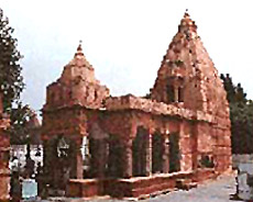
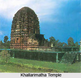
Khallarimatha Temple, Mahasamund, Chhattisgarh: Khallarimatha Temple is situated on a hilltop forest of Khallari village, about 25km south to Mahasamund. Every year during Navratri the devotees gather to visit the goddess and to participate in the annual fair scheduled on the full moon day of the month of Chaitra. It is believed that during the Mahabharata era, the Pandavas had frequented this hilltop; locals are of the belief that footprints of Bhima are visible throughout the hilly area.
Godhara of Dalali, Mahasamund, Chhattisgarh: About 10km eastside of Mahasamund, there is a place by the name of Dalali, where an archaic Shiva temple and a `godhara` can be witnessed. The water flows out in a continuous motion from Godhara, which is a curious feature for people to visit. During the months of Sravan and Poush, devotees come in great numbers to offer prayers, as these months are considered auspicious for Lord Shiva. A mela (fair) is put up for this grand occasion.
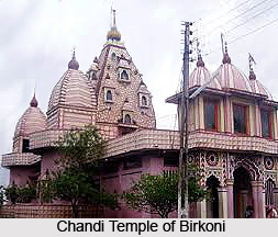
Chandi Temple of Guchapali, Mahasamund, Chhattisgarh: Guchapali village is located about 40km south of Mahasamund. The Chandi Temple`s prime attraction is the enormous natural, self-created statue of Devi Chandi, another manifestation of Goddess Durga. A mela (fair) is celebrated during Navratri in the Chaitra months.
Culture of Mahasamund District
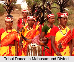 Culture of Mahasamund District is mainly predominantly tribal in nature that is directly linked to the topographical climate of the place and the ancient culture of the populace that has transmitted from the waterfall of the flowing time. Chhattisgarhi language is the lingua franca used in this district. However, Hindi language too is sparingly spoken in some parts of the district. In the blocks adjoining the state of Orissa like Saraipali and Basna, Oriya language along with Chhattisgarhi is spoken. In keeping with the traditions of Chhattisgarh, people of Mahasamund District have predilection for unostentatious clothing. Male members normally attire `Dhoti`, `Kurta` and Turban on their head with a piece of clothing round the neck and a special type of leather shoe (known as Bhandai). Female members prefer saree and blouse (Lugra and Polkha) and cover their feet with Atkaria, a special type of leather footwear. Ornaments include Bicchia for fingers, Parpatti or ankle band, Kardhan or waist bands, Fulee or ear rings made of silver. People in Mahasamund District celebrate several fairs and festivals throughout the year, from the month of Chaitra to Phalguna. Fairs and festivals adorn the cultural calendar of the region. The celebrations go on from the month of Chaitra to Phalguna. There is a custom of giving gifts and also inviting friends as well as relatives for feasts. The city is also known to provide a great scope for mining due to the fact that there is a great availability of Granite rocks and Limestone rocks.
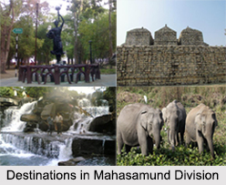
Tourism in Mahasamund District
 Tourism in Mahasamund District includes exploring the different places of interest offered by the district. Mahasamund District of Chhattisgarh is famous for its traditional background. The region, once capital of `South Kosal` ruled by `Somvanshi Emperors`, was also a centre of learning. Various temples here, with their natural and divine beauty, are always a delight for the visitors. The temples and the various fairs and festivals enhance the rich culture of the district.
Pilgrimage Tourism in Mahasamund District
This district covers many temples of the architectural beauty. Some of the temples are Khallarimatha temple, Chandi Temple, and many other temples.
Khallarimatha Temple
Khallarimatha temple is on the hilltop forest of Khallari village situated about 25 km south of Mahasamund. Every year during Navratri festival, large number of devotees visit this temple and participate in the annual fair (mela) scheduled on the full moon day of Chaitra month every year. It is believed that Pandavas of Mahabharat visited this hilltop. According to the beliefs of local people footprints of Bhima are visible on this hilltop.
 Sweth Ganga of Bhamini
In the village of Bhamini about 10 km west of Mahasamund, Swethganga is situated. Adjacent to this there is an old temple of Lord Shiva. A mela is organized during full moon of Magha month and on Shivaratri. During Shravan month the devotees called `Bolbum Kawariya` come here in groups for offering their prayers to Lord Shiva.
Godhara of Daldali
About 10 km east of Mahasamund there is a place called Daldali where there is an old Siva temple and Godhara. The water flows constantly from the Godhara. The village Daldali`s northeast side is covered by beautiful forests. During the months of Shravan and Poush, devotees in great numbers offer prayers here. During full moon of Poush Mela is celebrated here. It is considered as a great attraction for the tourists.
Chandi Temple of Birkoni
The Chandi Temple is in village Birkoni is located at around 10 km north of Mahasamund. During Navratri of Chaitra, huge number of devotees visits this temple and offer prayers.
Chandi Temple of Guchhapali
Guchhapali village is about 40 km south side of Mahasamund. The Chandi temple, which is having an idol of Devi Chandi, is situated in this village. Big fair is organized here during Navratri of Chaitra month.