
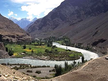
 The Gilgit River is located in Pakistan. More specifically, it is situated in the northern areas of Gilgit–Baltistan. It flows past the town of Gilgit and acts as a tributary of the Indus River. This river is also referred to as the Ghizar River.
Geography of Gilgit River
Globally, the Gilgit River can be pinpointed at coordinates 36 degrees 04 minutes 44 seconds north and 72 degrees 32 minutes 07 seconds east. The entire catchment area of this river is characterized as bleak and desolate. Along the Gilgit, Bunji is known to be the main human settlement.
Course of Gilgit River
The Gilgit River originates from a high alpine glacier near the extreme northwestern boundary of the Himalayas, in the area where the Hindu Kush, the Karakoram Range and the western (Punjab) Himalayas join. It then cuts across an offshoot of the Karakoram Range and journeys in the southern direction. This route is followed until the Ghizar River flowing in from the west, joins it. The Gilgit River then moves in the eastern direction and at Bunji merges with the river called the Indus. More specifically, the amalgamation takes place just before the River Indus has cut a path through the main Himalayan range. The total length of the course of Gilgit River is about 150 miles (240 km).
Tributaries of Gilgit River
The Ghiza River and the Hunza River are known to be main tributaries of Gilgit River.
Flora of Gilgit River
The Gilgit River has meagre vegetative growth. Low forms of plant occurring along water channels consist of the floral life of the Gilgit. They are evident from spring to autumn every year.
This article is a stub. You can enrich by adding more information to it. Send your Write Up to content@indianetzone.com
Related Articles:
Water Resources in India
Indian Rivers
Himalayan Rivers
Lakes of India
Estuaries of India
Coastal Rivers
Deccan Rivers









