
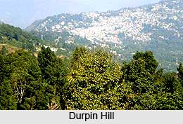
 Durpin hill which is also an observatory point is known for its beautiful views. It is located on the south west of the hilly town of Kalimpong in the West Bengal state of India. The hill is situated at an altitude of 1,372 metres above mean sea level. It is the highest point in Kalimpong. In addition to the scenic beauty, tourists visiting this place have ample opportunities to enjoy beautiful views of the Himalayan ranges.
Attractions of Durpin Hill
A ridge on which the town of Kalimpong is situated links the Durpin hill along with the Deolo hill. The hill provides a charming view of the town of Kalimpong, the snow capped Himalayan ranges of West Sikkim, the Teesta River and its valley and the Jelepla Pass at a distance. It also provides the spectacular view of the entire Chola Range of Sikkim. The other beautiful places that can be viewed from here comprise of Rangeet River, the Tiger hill, the Kanchenjunga range, Peshoke and Lopchu tea estates, Nathu-la pass and the towns of Siliguri and Kurseong.
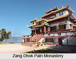
On the hilltop there is the Zang Dhok Palri Monastery set up by Dalai Lama in 1976. The monastery is one of the attractions of Durpin hill. It is home to the precious 108 volumes of the Kangyur. It also houses other holy books and scrolls that were moved out of Tibet after the Chinese invasion. The monastery is situated away from the town hence it is advisable to hire a taxi for the visit.
There is a base of the Indian Army on the Durpin hill since the hill is situated in the border region. Near the monastery the Indian Army built a helipad. The hill also offers exciting opportunity for an exhilarating trek.
Connectivity of Durpin Hill
It can be accessed via road, railway and also airway. Kalimpong is well connected to almost all the major cities of West Bengal by well maintained road connectivity. New Jalpaiguri is the nearest railway station which is about 67 km away from Kalimpong. The closest airport is Bagdogra, which is at a distance of 79 km from Kalimpong.









