 The state of Madhya Pradesh is located in central India. It is the second-largest state in India by area. The geographical terrain of this state is characterized by a plateau streaked with the hill ranges of the Vindhyas and the Satpuras, rivers, lakes and dense forests. The natural beauty of Madhya Pradesh, along with world heritage sites, several cities, hill stations, national parks, etc draw tourists to this state. To reach Madhya Pradesh, international and domestic airports have been established in the state.
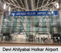
Devi Ahilyabai Holkar Airport
Devi Ahilyabai Holkar Airport is situated about 8 km west of Indore. This public airport is managed by Airports Authority of India. It occupies 729 acres of land. It"s terminal building occupies an area of about 18,000 square kilometers and it"s parking bays can accommodate 5 ATR-72, 4 Airbus A-321 and 3 Boeing 737 aircrafts simultaneously. This airport has been provided with night landing facilities, CAT- 1 instrument landing system and navigational facilities. It is regarded as the busiest airport in Madhya Pradesh.
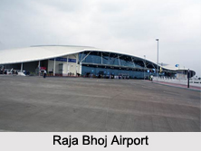
Raja Bhoj Airport
Raja Bhoj Airport is situated about 15 km (9.3 mi) north-west of Bhopal city center on National Highway 12 in the Gandhi Nagar area. This public airport is owned by Madhya Pradesh Government and operated by the Airports Authority of India. In 2013, Raja Bhoj Airport became the first airport of Madhya Pradesh to use solar power for running its utility grid system. This airport is well equipped with night landing facilities, an instrument landing system and CAT VII fire services.
 Jabalpur Airport
Jabalpur Airport is located about 25 km east of Jabalpur. This public airport occupies land of about 310.22 acres. It is operated by Airports Authority of India and links Jabalpur Metropolitan Agglomeration to other parts of India. The parking space in the airport can accommodate one A-320/B-737 or 2 ATR-72 aircrafts. The airport has been provided with night landing facilities and precision approach path indicator.
Gwalior Airport
Gwalior Airport is situated about 8 km to the northeast of the city of Gwalior. This airport has been provided with one domestic terminal. The airport"s runway has a length of about 9000 feet and its height is about 617 feet.
Khajuraho Airport
Khajuraho Airport is a civil aerodrome located in Khajuraho in the district of Chhatarpur. This public airport is also operated by Airports Authority of India. It has a runway with asphalt surface and is about 7,460 ft (2,274 m) in length.
Ujjain Airstrip
Ujjain Airstrip is located in Ujjain. This public airstrip is owned by the Government of Madhya Pradesh.
Other Airports in Madhya Pradesh
Some other airports in Madhya Pradesh are Dumna Airport, Rajmata Vijaya Raje Scindia Air Terminal, Chhindwara Airport, Satna Airport, Panna Airport, Dhana Airport, Khandwa Airport, Ratlam Airstrip.